Difference between revisions of "2013-08-11 53 -2"
imported>Angel |
imported>FippeBot m (Location) |
||
| (2 intermediate revisions by 2 users not shown) | |||
| Line 1: | Line 1: | ||
| − | |||
| − | |||
| − | |||
[[Image:{{{image|2013-08-11_53_-2_16-13-04-800.jpg}}}|thumb|left]] | [[Image:{{{image|2013-08-11_53_-2_16-13-04-800.jpg}}}|thumb|left]] | ||
| − | |||
| − | |||
| − | |||
| − | |||
| − | |||
{{meetup graticule | {{meetup graticule | ||
| lat=53 | | lat=53 | ||
| Line 35: | Line 27: | ||
== Tracklog == | == Tracklog == | ||
<!-- if your GPS device keeps a log, you may post a link here --> | <!-- if your GPS device keeps a log, you may post a link here --> | ||
| + | [http://www.endomondo.com/workouts/229111309/3871875 Tracklog on Endomondo] | ||
== Photos == | == Photos == | ||
| Line 53: | Line 46: | ||
<!-- Add any achievement ribbons you earned below, or remove this section --> | <!-- Add any achievement ribbons you earned below, or remove this section --> | ||
{{drag-along | latitude = 53 | longitude = -2 | date = 2013-08-11 | partner = Mum & Dennis | name = Angel }} | {{drag-along | latitude = 53 | longitude = -2 | date = 2013-08-11 | partner = Mum & Dennis | name = Angel }} | ||
| − | |||
| − | |||
| − | |||
[[Category:Expeditions]] | [[Category:Expeditions]] | ||
[[Category:Expeditions with photos]] | [[Category:Expeditions with photos]] | ||
| − | |||
[[Category:Coordinates reached]] | [[Category:Coordinates reached]] | ||
| + | {{location|GB|ENG|LAN}} | ||
Latest revision as of 03:35, 14 August 2019

| Sun 11 Aug 2013 in 53,-2: 53.6201854, -2.5367449 geohashing.info google osm bing/os kml crox |
Location
Near the source of the River Douglas, just off the footpath connecting Rivington Pike to Winter Hill. Surrounded by lovely Peak District scenery (I think)
Participants
- Angel
- Angel's drag-along, aka Angel's mum
- Angel's mum's drag-along, Dennis
Plans
Drive up to the car park below Rivington Pike, have a leisurely walk around the terraced gardens, then go up to the tower on top and head along the footpath until we see a river.
Expedition
Pretty uneventful. One thing I thought was a good omen, the Geohash Droid app on my phone switched from displaying the distance in miles, to feet, exactly as we got out of mum's car. Exactly according to plan, probably for the first time ever.
On the way home, I realised I could have set off earlier and followed the National Cycle Network route 91 all the way to the car park.
Tracklog
Photos
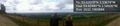
Half way there :) @53.6248,-2.5461
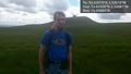
Made it :) With my mum and her bf, which I think earns me a new achievement. @53.6202,-2.5368
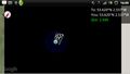
A screenshot at the point; unfortunately the satellite image went black on me, but you can see my location and the flag @53.6204,-2.5379

Achievements
Angel earned the Drag-along achievement
|