Difference between revisions of "2013-08-12 37 -122"
imported>Thomcat ([live picture] It's sunny in Sunnyvale [http://www.openstreetmap.org/?lat=37.36399139&lon=-122.01046112&zoom=16&layers=B000FTF @37.3640,-122.0105]) |
imported>FippeBot m (Location) |
||
| (2 intermediate revisions by one other user not shown) | |||
| Line 1: | Line 1: | ||
| − | |||
| − | |||
| − | |||
| − | |||
| − | |||
| − | |||
| − | |||
| − | |||
| − | |||
| − | |||
{{meetup graticule | {{meetup graticule | ||
| lat=37 | | lat=37 | ||
| lon=-122 | | lon=-122 | ||
| date=2013-08-12 | | date=2013-08-12 | ||
| + | | San Francisco | ||
| + | | San Francisco, California | ||
}} | }} | ||
| − | |||
__NOTOC__ | __NOTOC__ | ||
== Location == | == Location == | ||
| − | + | A residential sidewalk in the Ponderosa Park portion of Sunnyvale | |
== Participants == | == Participants == | ||
| − | + | * [[User:Thomcat|Thomcat]] | |
| − | |||
== Plans == | == Plans == | ||
| Line 28: | Line 18: | ||
== Expedition == | == Expedition == | ||
| − | + | Early morning in Seattle, finished airport parking at 6:30 am. Geohashdroid says the spot is south east of me, somewhere in Maple Valley. Oh well, couldn't have done that *and* the airport. | |
| + | |||
| + | But wait - that means the geohash point is in a cherry location in my destination, California! Subtracted ten from the latitude gives me 37, -122 and sure enough, the geohash point is in Sunnyvale. | ||
| + | |||
| + | A bit of judicious googling while waiting for the plane indicates I could likely get there through public transit from either the airport or the hotel, or by worst case walking. Waiting for public transit at the airport, I snapped a picture of the transit map, in case I had to do routing without google. | ||
| + | |||
| + | I opted for hitting the hotel first and planned out the rest of my day. Forgot the cell phone (GPS) charging cable, so I would need to go somewhere... Best Buy will do. Need to have dinner. Wouldn't mind visiting a local game store near the airport. Soon, the route was planned, and time to rush out the door! | ||
| + | |||
| + | Made it to the bus with less than a minute to spare, then waited 18 minutes for the transfer. With unlimited power, I would hack around and see if there were caches nearby, but instead I left my 3 year old weak battery alone. Next bus ride was smooth, and a pedestrian pathway led me into the neighborhood. | ||
| + | |||
| + | Walked down a street and over, then found the hash point quite easily. Funny thing, the curb was marked at (or within error) the hash point with XIII, so I scrawled XKCD above it and snapped a photo of both, then myself. These were all uploaded (yay for geohash droid and cell connectivity!) and I continued on to Best Buy. | ||
| − | + | Did some light reading over dinner, did manage to visit that game store, and finally returned to the hotel. What will tomorrow bring? | |
| − | |||
== Photos == | == Photos == | ||
| − | |||
| − | |||
| − | |||
<gallery perrow="5"> | <gallery perrow="5"> | ||
| Line 44: | Line 40: | ||
Image:2013-08-12_37_-122_17-33-15-479.jpg | It's sunny in Sunnyvale [http://www.openstreetmap.org/?lat=37.36399139&lon=-122.01046112&zoom=16&layers=B000FTF @37.3640,-122.0105] | Image:2013-08-12_37_-122_17-33-15-479.jpg | It's sunny in Sunnyvale [http://www.openstreetmap.org/?lat=37.36399139&lon=-122.01046112&zoom=16&layers=B000FTF @37.3640,-122.0105] | ||
| + | |||
| + | Image:2013-08-12_37_-122_18-14-57-552.jpg | Dinner - still sunny [http://www.openstreetmap.org/?lat=37.35813438&lon=-122.01988816&zoom=16&layers=B000FTF @37.3581,-122.0199] | ||
</gallery> | </gallery> | ||
== Achievements == | == Achievements == | ||
{{#vardefine:ribbonwidth|800px}} | {{#vardefine:ribbonwidth|800px}} | ||
| − | + | {{Public transport geohash | latitude = 37 | longitude = -122 | date = 2013-08-12 | name = Thomcat | busline = VTA | | |
| + | image = 2013-08-12_37_-122_14-50-43-481.jpg | ||
| + | }} | ||
| − | |||
| − | |||
| − | |||
| − | |||
| − | |||
| − | |||
| − | |||
| − | |||
| − | |||
| − | |||
| − | |||
[[Category:Expeditions]] | [[Category:Expeditions]] | ||
| − | |||
[[Category:Expeditions with photos]] | [[Category:Expeditions with photos]] | ||
| − | |||
| − | |||
| − | |||
| − | |||
| − | |||
[[Category:Coordinates reached]] | [[Category:Coordinates reached]] | ||
| − | + | {{location|US|CA|SL}} | |
| − | |||
| − | |||
| − | |||
| − | |||
| − | |||
| − | |||
| − | |||
| − | |||
| − | |||
| − | |||
| − | |||
| − | |||
| − | |||
| − | |||
| − | |||
| − | |||
| − | |||
Latest revision as of 03:35, 14 August 2019
| Mon 12 Aug 2013 in 37,-122: 37.3639954, -122.0104473 geohashing.info google osm bing/os kml crox |
Location
A residential sidewalk in the Ponderosa Park portion of Sunnyvale
Participants
Plans
Headed there via #57 then #32 VTA bus. ETA 5:30-ish
Expedition
Early morning in Seattle, finished airport parking at 6:30 am. Geohashdroid says the spot is south east of me, somewhere in Maple Valley. Oh well, couldn't have done that *and* the airport.
But wait - that means the geohash point is in a cherry location in my destination, California! Subtracted ten from the latitude gives me 37, -122 and sure enough, the geohash point is in Sunnyvale.
A bit of judicious googling while waiting for the plane indicates I could likely get there through public transit from either the airport or the hotel, or by worst case walking. Waiting for public transit at the airport, I snapped a picture of the transit map, in case I had to do routing without google.
I opted for hitting the hotel first and planned out the rest of my day. Forgot the cell phone (GPS) charging cable, so I would need to go somewhere... Best Buy will do. Need to have dinner. Wouldn't mind visiting a local game store near the airport. Soon, the route was planned, and time to rush out the door!
Made it to the bus with less than a minute to spare, then waited 18 minutes for the transfer. With unlimited power, I would hack around and see if there were caches nearby, but instead I left my 3 year old weak battery alone. Next bus ride was smooth, and a pedestrian pathway led me into the neighborhood.
Walked down a street and over, then found the hash point quite easily. Funny thing, the curb was marked at (or within error) the hash point with XIII, so I scrawled XKCD above it and snapped a photo of both, then myself. These were all uploaded (yay for geohash droid and cell connectivity!) and I continued on to Best Buy.
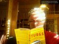
Did some light reading over dinner, did manage to visit that game store, and finally returned to the hotel. What will tomorrow bring?
Photos
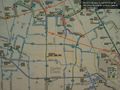
Bus route map - San Jose airport @37.3640,-121.9226
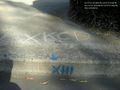
Curb message from Sunnyvale @37.3640,-122.0105

It's sunny in Sunnyvale @37.3640,-122.0105
Dinner - still sunny @37.3581,-122.0199


Achievements
Thomcat earned the Public transport geohash achievement
|