Difference between revisions of "2013-08-15 48 9"
From Geohashing
imported>Steingesicht (did some optimisation an added the achievement) |
m |
||
| (2 intermediate revisions by 2 users not shown) | |||
| Line 1: | Line 1: | ||
| − | {{meetup graticule | lat=48 | lon=9 | date=2013- | + | {{meetup graticule | lat=48 | lon=9 | date=2013-08-15 }} |
[[2013-08-15 48 9|2013-08-15]]: [[User:Hansundgrete|Hansundgrete]] have been on the way to visit their first geohash. | [[2013-08-15 48 9|2013-08-15]]: [[User:Hansundgrete|Hansundgrete]] have been on the way to visit their first geohash. | ||
| Line 14: | Line 14: | ||
== Achievements == | == Achievements == | ||
{{land geohash | latitude = 48 | longitude = 9 | date = 2013-08-15 | name = Hansundgrete}} | {{land geohash | latitude = 48 | longitude = 9 | date = 2013-08-15 | name = Hansundgrete}} | ||
| + | |||
| + | [[Category:Expeditions]] | ||
| + | [[Category:Expeditions with photos]] | ||
| + | [[Category:Coordinates reached]] | ||
| + | {{location|DE|BW|UL}} | ||
Latest revision as of 13:07, 22 September 2021
| Thu 15 Aug 2013 in 48,9: 48.4968941, 9.8817539 geohashing.info google osm bing/os kml crox |
2013-08-15: Hansundgrete have been on the way to visit their first geohash.
Location
in a little fir wood somewhere between temmenhausen and tomerdingen, near ulm, south germany
Participants
Expedition
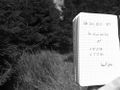
starting at the parking lot near the cementary in tomerdingen we took the way via a biotope for the short hike to the desired spot. the farmers harvested their fields, raptorial birds took their flying hours and additionally to taking photos we made some field recordings[1] what the bees found very interesting. arrived at the gz we took some pictures but sadly we were so excited about our first gh we didn't make a correct photo as a log proof;-(
all in all we had a great time and we could say that this was definitely not our last geohash.
ulm,germany

Achievements
Hansundgrete earned the Land geohash achievement
|