Difference between revisions of "2013-08-16 42 -123"
From Geohashing
imported>Frogman (→Plans) |
imported>FippeBot m (Location) |
||
| (5 intermediate revisions by 2 users not shown) | |||
| Line 15: | Line 15: | ||
}} | }} | ||
| − | + | ||
__NOTOC__ | __NOTOC__ | ||
== Location == | == Location == | ||
| Line 21: | Line 21: | ||
== Participants == | == Participants == | ||
| − | + | ||
| − | + | * [[User:Frogman|Frogman]] | |
| − | * [[User:Frogman|Frogman]] | + | * A good bit of [[User:Frogman|Frogman]]'s family |
| − | * A good bit of [[User:Frogman|Frogman]] | ||
== Plans == | == Plans == | ||
| − | + | ||
| − | We were planning on driving this stretch of 42 anyway, so we decided to try to pop by the hashpoint and possibly have a picnic there. | + | We were planning on driving this stretch of Hwy 42 anyway, so we decided to try to pop by the hashpoint and possibly have a picnic there. |
== Expedition == | == Expedition == | ||
| − | |||
| − | + | The expedition stopped short when we realized that the roads were not open to public access. Luckily, this happened right away, so not much time was lost! | |
| − | + | ||
== Photos == | == Photos == | ||
| − | + | ||
| − | |||
| − | |||
<gallery perrow="5"> | <gallery perrow="5"> | ||
| + | Image:IMAG0095.jpg|Private Property! A tragedy | ||
| + | Image:2013-08-16 goofygrins.jpg|Goofy grins | ||
</gallery> | </gallery> | ||
== Achievements == | == Achievements == | ||
{{#vardefine:ribbonwidth|800px}} | {{#vardefine:ribbonwidth|800px}} | ||
| − | |||
| − | |||
| − | |||
| − | |||
| − | |||
| − | + | {{No trespassing | |
| − | + | | latitude = 42 | |
| − | + | | longitude = -123 | |
| − | + | | date = 2013-08-16 | |
| + | | name = frogman | ||
| + | | distance = 9 miles | ||
| + | }} | ||
| − | |||
[[Category:Expeditions]] | [[Category:Expeditions]] | ||
| − | |||
[[Category:Expeditions with photos]] | [[Category:Expeditions with photos]] | ||
| − | |||
| − | |||
| − | |||
| − | |||
| − | |||
| − | |||
| − | |||
| − | |||
| − | |||
| − | |||
| − | |||
| − | |||
| − | |||
| − | |||
| − | |||
| − | |||
| − | |||
| − | |||
| − | |||
| − | |||
| − | |||
| − | |||
| − | |||
| − | |||
[[Category:Coordinates not reached]] | [[Category:Coordinates not reached]] | ||
[[Category:Not reached - No public access]] | [[Category:Not reached - No public access]] | ||
| + | {{location|US|OR|DO}} | ||
Latest revision as of 03:37, 14 August 2019
| Fri 16 Aug 2013 in 42,-123: 42.9088250, -123.6835751 geohashing.info google osm bing/os kml crox |
Location
A BLM road off of Oregon State Highway 42.
Participants
Plans
We were planning on driving this stretch of Hwy 42 anyway, so we decided to try to pop by the hashpoint and possibly have a picnic there.
Expedition
The expedition stopped short when we realized that the roads were not open to public access. Luckily, this happened right away, so not much time was lost!
Photos
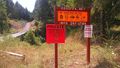
Private Property! A tragedy
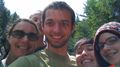
Goofy grins


Achievements
frogman earned the No trespassing consolation prize
|