Difference between revisions of "2013-08-17 46 8"
imported>Chris 47 8 (stuff added) |
imported>Chris 47 8 (expedition and pictures added - finally!) |
||
| Line 1: | Line 1: | ||
| − | |||
| − | [[Image: | + | [[Image:2013-08-17_46_8-07.JPG|thumb|left]] |
| − | |||
| − | |||
| − | |||
| − | |||
| − | |||
{{meetup graticule | {{meetup graticule | ||
| lat=46 | | lat=46 | ||
| Line 15: | Line 9: | ||
}} | }} | ||
| − | + | ||
__NOTOC__ | __NOTOC__ | ||
== Location == | == Location == | ||
| Line 23: | Line 17: | ||
== Plans == | == Plans == | ||
| − | Hike up to | + | Hike up to Fronalpstock, take the cable car back down, get the hash. |
== Expedition == | == Expedition == | ||
| − | + | That was a really beautiful expedition. I went to the town Morschach by train and bus, and hiked up to the Fronalpstock mountain from there. I had planned to go hiking that weekend anyways. The route up was quite dangerous and i had to climb at some parts, but im an experienced hiker and own the necessary equipment to do such things. I had some food and water with me for the two hours i calculated to make the 1400 meters in altitude. | |
| + | |||
| + | Next to the peak of Fronalpstock is a restaurant. A cable car is going up there, it's a well known ski resort in winter and a nice place for hiking in summer. There was a Alphorn performance going on there for the tourists. The view from the top was just breathtaking. | ||
| + | |||
| + | I took the cable car back down to the valley, and walked to the hash, which was very close to the valley station of the Stoos cable car. The coordinates turned out to be exactly at the entrance to a military bunker, located at the road towards Muotathal. | ||
| + | |||
| + | From there i took the bus back home. | ||
== Tracklog == | == Tracklog == | ||
| Line 32: | Line 32: | ||
== Photos == | == Photos == | ||
| − | |||
| − | < | + | <gallery perrow="4"> |
| − | Image: | + | |
| − | -- | + | Image:2013-08-17_46_8-01.JPG | An alpine farmer house, Mythen mountains in the background |
| − | + | Image:2013-08-17_46_8-02.JPG | On the way up | |
| + | Image:2013-08-17_46_8-03.JPG | The route was quite dangerous | ||
| + | Image:2013-08-17_46_8-04.JPG | Platform next to the restaurant | ||
| + | Image:2013-08-17_46_8-05.JPG | Alphorn performance | ||
| + | Image:2013-08-17_46_8-06.JPG | The peak of Fronalpstock | ||
| + | Image:2013-08-17_46_8-07.JPG | The view from there | ||
| + | Image:2013-08-17_46_8-08.JPG | Cable car back down | ||
| + | Image:2013-08-17_46_8-09.PNG | Coordinates reached | ||
| + | Image:2013-08-17_46_8-10.JPG | The hash was where the door is | ||
| + | Image:2013-08-17_46_8-11.JPG | The road towards Muotathal | ||
| + | |||
</gallery> | </gallery> | ||
== Achievements == | == Achievements == | ||
{{#vardefine:ribbonwidth|800px}} | {{#vardefine:ribbonwidth|800px}} | ||
| − | + | none of interest | |
| − | |||
[[Category:Expeditions]] | [[Category:Expeditions]] | ||
[[Category:Expeditions with photos]] | [[Category:Expeditions with photos]] | ||
[[Category:Coordinates reached]] | [[Category:Coordinates reached]] | ||
Revision as of 14:40, 12 January 2014

| Sat 17 Aug 2013 in 46,8: 46.9922070, 8.6898030 geohashing.info google osm bing/os kml crox |
Location
Close to the station of the Stoos cable car.
Participants
Plans
Hike up to Fronalpstock, take the cable car back down, get the hash.
Expedition
That was a really beautiful expedition. I went to the town Morschach by train and bus, and hiked up to the Fronalpstock mountain from there. I had planned to go hiking that weekend anyways. The route up was quite dangerous and i had to climb at some parts, but im an experienced hiker and own the necessary equipment to do such things. I had some food and water with me for the two hours i calculated to make the 1400 meters in altitude.
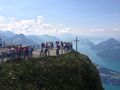
Next to the peak of Fronalpstock is a restaurant. A cable car is going up there, it's a well known ski resort in winter and a nice place for hiking in summer. There was a Alphorn performance going on there for the tourists. The view from the top was just breathtaking.
I took the cable car back down to the valley, and walked to the hash, which was very close to the valley station of the Stoos cable car. The coordinates turned out to be exactly at the entrance to a military bunker, located at the road towards Muotathal.
From there i took the bus back home.
Tracklog
n/a
Photos
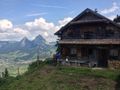
An alpine farmer house, Mythen mountains in the background
On the way up
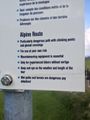
The route was quite dangerous
Platform next to the restaurant
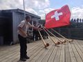
Alphorn performance
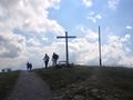
The peak of Fronalpstock
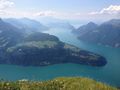
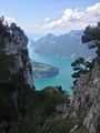
The view from there
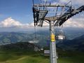
Cable car back down
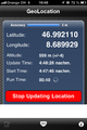
Coordinates reached
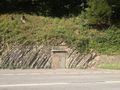
The hash was where the door is
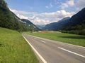
The road towards Muotathal


Achievements
none of interest