Difference between revisions of "2013-08-23 48 1"
imported>Dunaril |
imported>FippeBot m (Location) |
||
| (11 intermediate revisions by one other user not shown) | |||
| Line 1: | Line 1: | ||
| + | [[Image:{{{image|2013-08-23_48_1_19-33-02-633.jpg}}}|thumb|left]] | ||
| − | |||
| − | |||
| − | |||
| − | |||
| − | |||
| − | |||
| − | |||
| − | |||
| − | |||
{{meetup graticule | {{meetup graticule | ||
| lat=48 | | lat=48 | ||
| Line 18: | Line 10: | ||
== Location == | == Location == | ||
| − | An open field in Authon-la-Plaine, very close to the A10 and even one of its interchanges. | + | An open field in Authon-la-Plaine, very close to the A10 between Paris and Orléans, and even one of its interchanges (exit 11). |
== Participants == | == Participants == | ||
| − | [[User:Dunaril|Dunaril]] and [[User:Katu|Katu]] | + | [[User:Dunaril|Dunaril]] and [[User:Katu|Katu]]. |
== Plans == | == Plans == | ||
| Line 28: | Line 20: | ||
If everything goes *very fine* we'll even possibly score a [[2013-08-23 47 0|multihash]]. | If everything goes *very fine* we'll even possibly score a [[2013-08-23 47 0|multihash]]. | ||
| + | |||
| + | *Closing in -- [[User:Dunaril|Dunaril]] ([[User talk:Dunaril|talk]]) [http://www.openstreetmap.org/?lat=48.45402082&lon=1.92735644&zoom=16&layers=B000FTF @48.4540,1.9274] 19:20, 23 August 2013 (CEST) | ||
== Expedition == | == Expedition == | ||
| − | + | ||
| + | We were headed from our home in Paris to a friend's house close to Amboise, for a nice week-end of hanging out and kayaking under the Chenonceau castle. Having to leave on Friday after work was dooming us to getting jams on the way out of Paris, so we were expected to arrive quite late in the evening. Besides, it turned out that most of our friends headed in the same direction were behind us, so we had a bit of a time slop for our journey. What would '''you''' do in such circumstances, and when the Gods of Xkcd and the Stock Exchange have conjointly elected to place two geohashes less than 5km away from your journey? We only did what we had to. | ||
| + | |||
| + | The coordinates were in quite a trivial place, 3km East from the exit 11 of the A10 highway, and in a field just 150m from the nearest road. We left the highway and drove to the location in just 5 minutes. With the setting sun it was a pleasant time to be wandering between the fields - and a nice break from our jammed trip too. | ||
| + | |||
| + | A tractor was at work in a neighbor field and we wondered a bit about how lawful it was to walk inside a field, but the short distance and the fact it was ploughed and we couldn't do any damage conviced me to keep going. We walked in a not-so-straight line to the point, my orientation skills having misteriously disappeared when we entered the field - I couldn't tell where the north was. Finally the Geohash Droid app gave us the green light - literally showing the distance to the hash in green, meaning that it was within my phone's GPS accuracy circle. We took the customary picture and went back to the car, ready to pursue our journey South and to try our luck in [[2013-08-23 47 0|another graticule]]. | ||
| + | |||
| + | * Question to fellow geohashers: the highway we took for our trip had a toll. We entered the toll zone when leaving Paris, paid when we got out to get at the geohash, and then went back to the highway (and back to the toll zone) after we hashed, to pursue our journey. We paid a second time when leaving the highway for real near Amboise, so the first toll was really paid because we went geohashing. Do we qualify for the Admit One achievement? | ||
| + | |||
| + | ** Answer by [[User:Tilley|Tilley]] on the [[Talk:2013-08-23_48_1|talk page]]: it's not qualifying because one could reach the geohash without using the highway and paying the toll. | ||
| + | |||
== Photos == | == Photos == | ||
| − | |||
| − | |||
| − | |||
<gallery perrow="5"> | <gallery perrow="5"> | ||
| + | |||
| + | Image:2013-08-23_48_1_19-33-02-633.jpg | [http://www.openstreetmap.org/?lat=48.45750000&lon=1.94918000&zoom=16&layers=B000FTF @48.4575,1.9492] Taken on the hash as far as we can tell, but the GPS hoped a bit while we marked and uploaded it. | ||
| + | |||
| + | Image:2013-08-23_48_1_19-36-33-662.jpg | [http://www.openstreetmap.org/?lat=48.44730000&lon=1.95193000&zoom=16&layers=B000FTF @48.4473,1.9519] View of the hash point and field, rather 150m from there (where we parked). | ||
</gallery> | </gallery> | ||
| − | + | ||
== Achievements == | == Achievements == | ||
{{#vardefine:ribbonwidth|800px}} | {{#vardefine:ribbonwidth|800px}} | ||
| − | + | {{land geohash | latitude = 48 | longitude = 1 | date = 2013-08-23 | name = [[User:Dunaril|Dunaril]] and [[User:Katu|Katu]]}} | |
| + | {{Minesweeper geohash | graticule = Paris, France | ranknumber = 2 | sw = true | w = true | name = [[User:Dunaril|Dunaril]] and [[User:Katu|Katu]] }} | ||
| − | |||
| − | |||
| − | |||
[[Category:Expeditions]] | [[Category:Expeditions]] | ||
| − | |||
[[Category:Expeditions with photos]] | [[Category:Expeditions with photos]] | ||
| − | + | ||
| − | |||
| − | |||
| − | |||
| − | |||
[[Category:Coordinates reached]] | [[Category:Coordinates reached]] | ||
| − | + | {{location|FR|91}} | |
| − | |||
| − | |||
| − | |||
| − | |||
| − | |||
| − | |||
| − | |||
| − | |||
| − | |||
| − | |||
| − | |||
| − | |||
| − | |||
| − | |||
| − | |||
| − | |||
| − | |||
Latest revision as of 06:24, 6 August 2019

| Fri 23 Aug 2013 in 48,1: 48.4573643, 1.9493154 geohashing.info google osm bing/os kml crox |
Location
An open field in Authon-la-Plaine, very close to the A10 between Paris and Orléans, and even one of its interchanges (exit 11).
Participants
Plans
We are driving from Paris to around Amboise in the evening, and so we'll try to exit the A10 and pass by the geohash quickly.
If everything goes *very fine* we'll even possibly score a multihash.
- Closing in -- Dunaril (talk) @48.4540,1.9274 19:20, 23 August 2013 (CEST)
Expedition
We were headed from our home in Paris to a friend's house close to Amboise, for a nice week-end of hanging out and kayaking under the Chenonceau castle. Having to leave on Friday after work was dooming us to getting jams on the way out of Paris, so we were expected to arrive quite late in the evening. Besides, it turned out that most of our friends headed in the same direction were behind us, so we had a bit of a time slop for our journey. What would you do in such circumstances, and when the Gods of Xkcd and the Stock Exchange have conjointly elected to place two geohashes less than 5km away from your journey? We only did what we had to.
The coordinates were in quite a trivial place, 3km East from the exit 11 of the A10 highway, and in a field just 150m from the nearest road. We left the highway and drove to the location in just 5 minutes. With the setting sun it was a pleasant time to be wandering between the fields - and a nice break from our jammed trip too.
A tractor was at work in a neighbor field and we wondered a bit about how lawful it was to walk inside a field, but the short distance and the fact it was ploughed and we couldn't do any damage conviced me to keep going. We walked in a not-so-straight line to the point, my orientation skills having misteriously disappeared when we entered the field - I couldn't tell where the north was. Finally the Geohash Droid app gave us the green light - literally showing the distance to the hash in green, meaning that it was within my phone's GPS accuracy circle. We took the customary picture and went back to the car, ready to pursue our journey South and to try our luck in another graticule.
- Question to fellow geohashers: the highway we took for our trip had a toll. We entered the toll zone when leaving Paris, paid when we got out to get at the geohash, and then went back to the highway (and back to the toll zone) after we hashed, to pursue our journey. We paid a second time when leaving the highway for real near Amboise, so the first toll was really paid because we went geohashing. Do we qualify for the Admit One achievement?
Photos
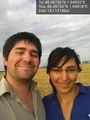
@48.4575,1.9492 Taken on the hash as far as we can tell, but the GPS hoped a bit while we marked and uploaded it.
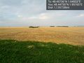
@48.4473,1.9519 View of the hash point and field, rather 150m from there (where we parked).

Achievements
Dunaril and Katu earned the Land geohash achievement
|
Dunaril and Katu achieved level 2 of the Minesweeper Geohash achievement
|