Difference between revisions of "2013-08-24 33 -117"
From Geohashing
imported>LucasBrown (Geohash Droid details page at the hashpoint) |
imported>LucasBrown (→Photos) |
||
| Line 17: | Line 17: | ||
Image:2013-08-24_33_-117_20-00-14-376.jpg | Regional map at the hashpoint | Image:2013-08-24_33_-117_20-00-14-376.jpg | Regional map at the hashpoint | ||
Image:2013-08-24_33_-117_20-00-39-430.jpg | Local map at hashpoint | Image:2013-08-24_33_-117_20-00-39-430.jpg | Local map at hashpoint | ||
| − | |||
| − | |||
</gallery> | </gallery> | ||
Revision as of 03:07, 25 August 2013
| Sat 24 Aug 2013 in 33,-117: 33.0548144, -117.2656973 geohashing.info google osm bing/os kml crox |
Location
A tree with a plate fungus off Calle de Cherie in Encinitas, CA
Participants
Notes
Part 3 of a triplehash. See also 2013-08-24 34 -118 and 2013-08-24 34 -117.
Photos
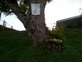
Sign and fungus at the hashpoint
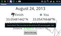
Geohash Droid details page at the hashpoint
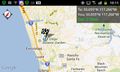
Regional map at the hashpoint
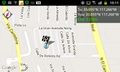
Local map at hashpoint


Achievements
LucasBrown earned the Multihash Achievement
|