Difference between revisions of "2013-08-25 44 -123"
imported>Taper (→Plans) |
(Eliminating redlinks) |
||
| (8 intermediate revisions by 3 users not shown) | |||
| Line 15: | Line 15: | ||
}} | }} | ||
| − | + | ||
__NOTOC__ | __NOTOC__ | ||
== Location == | == Location == | ||
| − | + | ||
The West Eugene Wetlands, in Eugene, Oregon. | The West Eugene Wetlands, in Eugene, Oregon. | ||
== Participants == | == Participants == | ||
| − | + | ||
| − | + | * [[User:Taper|Taper]] | |
| − | [[User:Taper|Taper]] | ||
== Plans == | == Plans == | ||
| − | + | ||
| − | I saw Friday that the hashes for | + | I saw Friday that the hashes for {{egl|2013-08-24|44|-123|text=Saturday}} and Sunday were relatively close to/in town, so decided to try for them; Saturday's expedition was called off when my phone/GPS battery died during journey preparations. "Sunday or bust!" I vowed. Well, no, not really. |
== Expedition == | == Expedition == | ||
| − | + | ||
| + | There was torrential rain when I left my house, but I decided to press forward anyway. The satellite map for the hash (I use the android app) seemed pretty straightforward -- it was in a field of some sort out in West Eugene, along a straight trail leading from the road. So, I drove out to the trailhead, arriving about 6:45 PM. There was a gate right there, and a sign proclaiming the field to be the West Eugene Wetlands. The rain had slowed slightly. | ||
| + | |||
| + | I stepped through the open pedestrian passage and followed the trail for about 500 feet, checking the GPS reading on my phone only sporadically so it wouldn't get rained on too much. And there I was! Or at least the app said so, due to the margin of error of GPS reception. Huzzah! | ||
| + | |||
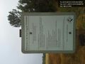
| + | I took some pictures, and walked back. It was then that I noticed the red barrier tape that had been torn down and was lying around the gate, and the second sign -- which declared that the West Eugene Wetlands was closed to public access through August 29. Um. Oops. Oh, well, no harm, no foul. | ||
== Tracklog == | == Tracklog == | ||
| − | + | ||
| + | I don't have a proper track log. The original label on the "grin" photo said over 100 feet away, but that was in error. The EXIF data from the hash photos (middle two, below) are: | ||
| + | |||
| + | |||
| + | 44 deg 3' 5.93" N 123 deg 9' 27.20" W - 7 meters away | ||
| + | |||
| + | 44 deg 3' 5.79" N 123 deg 9' 27.22" W - ''also'' 7 meters away | ||
| + | |||
| + | And I wandered a bit to the east of the trail in-between, as well, so I'm sure I hit the hash in there. | ||
== Photos == | == Photos == | ||
| − | + | ||
| − | |||
| − | |||
<gallery perrow="5"> | <gallery perrow="5"> | ||
| − | + | Image:2013-08-25_44_-123_18-57-12-218.jpg | Ah, public land, and the hash point was almost directly on the trail. | |
Image:2013-08-25_44_-123_18-52-10-300.jpg | Woo, hash in the rain. [http://www.openstreetmap.org/?lat=44.05160000&lon=-123.15800000&zoom=16&layers=B000FTF @44.0516,-123.1580] | Image:2013-08-25_44_-123_18-52-10-300.jpg | Woo, hash in the rain. [http://www.openstreetmap.org/?lat=44.05160000&lon=-123.15800000&zoom=16&layers=B000FTF @44.0516,-123.1580] | ||
| − | + | Image:2013-08-25_18.47.52.jpg | And the walk was thiiiiis far. | |
| − | Image:2013-08- | ||
| − | |||
Image:2013-08-25_44_-123_18-58-16-891.jpg | I missed this other sign going in, though. Um... oops? [http://www.openstreetmap.org/?lat=44.05040000&lon=-123.15800000&zoom=16&layers=B000FTF @44.0504,-123.1580] | Image:2013-08-25_44_-123_18-58-16-891.jpg | I missed this other sign going in, though. Um... oops? [http://www.openstreetmap.org/?lat=44.05040000&lon=-123.15800000&zoom=16&layers=B000FTF @44.0504,-123.1580] | ||
</gallery> | </gallery> | ||
| Line 51: | Line 59: | ||
== Achievements == | == Achievements == | ||
{{#vardefine:ribbonwidth|800px}} | {{#vardefine:ribbonwidth|800px}} | ||
| − | |||
| + | {{land geohash | latitude=44 | longitude=-123 | date=2013-08-25 | name=Taper }} | ||
| + | {{Drowned rat geohash | latitude = 44 | longitude = -123 | date = 2013-08-25 | name = Taper | image = 2013-08-25 44 -123 18-52-10-300.jpg | reason = walking for a few minutes in not quite a downpour | honourable = yes }} | ||
| − | |||
| − | |||
| − | |||
| − | |||
| − | |||
| − | |||
| − | |||
| − | |||
[[Category:Expeditions]] | [[Category:Expeditions]] | ||
| − | + | ||
[[Category:Expeditions with photos]] | [[Category:Expeditions with photos]] | ||
| − | |||
| − | |||
| − | |||
| − | |||
| − | |||
[[Category:Coordinates reached]] | [[Category:Coordinates reached]] | ||
| − | + | {{location|US|OR|LE}} | |
| − | |||
| − | |||
| − | |||
| − | |||
| − | |||
| − | |||
| − | |||
| − | |||
| − | |||
| − | |||
| − | |||
| − | |||
| − | |||
| − | |||
| − | |||
| − | |||
| − | |||
Latest revision as of 14:48, 22 March 2020
| Sun 25 Aug 2013 in 44,-123: 44.0516226, -123.1574757 geohashing.info google osm bing/os kml crox |
Location
The West Eugene Wetlands, in Eugene, Oregon.
Participants
Plans
I saw Friday that the hashes for Saturday and Sunday were relatively close to/in town, so decided to try for them; Saturday's expedition was called off when my phone/GPS battery died during journey preparations. "Sunday or bust!" I vowed. Well, no, not really.
Expedition
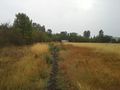
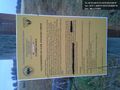
There was torrential rain when I left my house, but I decided to press forward anyway. The satellite map for the hash (I use the android app) seemed pretty straightforward -- it was in a field of some sort out in West Eugene, along a straight trail leading from the road. So, I drove out to the trailhead, arriving about 6:45 PM. There was a gate right there, and a sign proclaiming the field to be the West Eugene Wetlands. The rain had slowed slightly.
I stepped through the open pedestrian passage and followed the trail for about 500 feet, checking the GPS reading on my phone only sporadically so it wouldn't get rained on too much. And there I was! Or at least the app said so, due to the margin of error of GPS reception. Huzzah!
I took some pictures, and walked back. It was then that I noticed the red barrier tape that had been torn down and was lying around the gate, and the second sign -- which declared that the West Eugene Wetlands was closed to public access through August 29. Um. Oops. Oh, well, no harm, no foul.
Tracklog
I don't have a proper track log. The original label on the "grin" photo said over 100 feet away, but that was in error. The EXIF data from the hash photos (middle two, below) are:
44 deg 3' 5.93" N 123 deg 9' 27.20" W - 7 meters away
44 deg 3' 5.79" N 123 deg 9' 27.22" W - also 7 meters away
And I wandered a bit to the east of the trail in-between, as well, so I'm sure I hit the hash in there.
Photos
Ah, public land, and the hash point was almost directly on the trail.

Woo, hash in the rain. @44.0516,-123.1580
And the walk was thiiiiis far.
I missed this other sign going in, though. Um... oops? @44.0504,-123.1580


Achievements
Taper earned the Land geohash achievement
|
Taper earned the Drowned Rat Geohash Honourable Mention
|