Difference between revisions of "2013-08-27 49 9"
imported>GeorgDerReisende (expedition near Höchberg) |
imported>GeorgDerReisende (expedition report) |
||
| Line 2: | Line 2: | ||
<!-- If you did not specify these parameters in the template, please substitute appropriate values for IMAGE, LAT, LON, and DATE (YYYY-MM-DD format) | <!-- If you did not specify these parameters in the template, please substitute appropriate values for IMAGE, LAT, LON, and DATE (YYYY-MM-DD format) | ||
| − | |||
| − | |||
| − | |||
| − | |||
| − | |||
| − | |||
| − | |||
{{meetup graticule | {{meetup graticule | ||
| lat=49 | | lat=49 | ||
| Line 18: | Line 11: | ||
__NOTOC__ | __NOTOC__ | ||
== Location == | == Location == | ||
| − | + | ||
| + | The hash lies on a meadow near Höchberg. | ||
== Participants == | == Participants == | ||
| − | + | ||
| − | + | [[User:GeorgDerReisende|GeorgDerReisende]] | |
== Plans == | == Plans == | ||
| − | + | ||
| + | To go there, by hitchhiking, taking some photos, then going home, again by hitchhiking. | ||
== Expedition == | == Expedition == | ||
| − | + | ||
| + | I had calculated a travel time of about 5 1/2 hours for the way to Höchberg and the same time for the way home. With this calculation I started at the last possible time, at 11:30. I have went to the truckstop ''Lohfeldener Rüssel'' and asked there drivers, if they are going south. After 15 minutes I got a car going to the service station ''Hasselberg'', with about no waiting time I got there a car to the service station ''Großenmoor'', but there I had to wait for one hour and got then a truck to the service station ''Riedener Wald''. From there I got another car within 30 minutes to Würzburg, where I arrived at 16:45. By taking the bus and then not walking straight ahead I arrived at the hash at 18:00. There I have taken the necessary proof and pictures. Then I have walked back to Höchberg, but again not the direct way and I have taken some useless photos again. A roe deer was looking around, what I was doing there. | ||
| + | |||
| + | I started hitchhiking at 19:40, which had been one hour behind my plan, I got a car to the service station ''Riedener Wald'', after a waiting time of one hour a car to the service station ''Hasselberg'' and after an another waiting time of 30 minutes a car to the exit ''Wilhelmshöhe'', from which I got another car for four kilometers. The last way I had to walk, so I arrived at home at about 2:45. | ||
== Tracklog == | == Tracklog == | ||
| Line 34: | Line 32: | ||
== Photos == | == Photos == | ||
| − | |||
| − | |||
| − | |||
<gallery perrow="5"> | <gallery perrow="5"> | ||
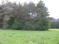
| + | Image:2013-08-27 49 9 GeorgDerReisende 8770.jpg | the hash lies somewhere to the right | ||
| + | Image:2013-08-27 49 9 GeorgDerReisende 8777.jpg | proof1 | ||
| + | Image:2013-08-27 49 9 GeorgDerReisende 8778.jpg | proof2 | ||
| + | Image:2013-08-27 49 9 GeorgDerReisende 8779.jpg | the south | ||
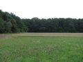
| + | Image:2013-08-27 49 9 GeorgDerReisende 8780.jpg | the east | ||
| + | Image:2013-08-27 49 9 GeorgDerReisende 8781.jpg | the north | ||
| + | Image:2013-08-27 49 9 GeorgDerReisende 8782.jpg | the west | ||
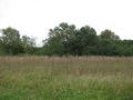
| + | Image:2013-08-27 49 9 GeorgDerReisende 8818.jpg | some scenery of Unterfranken | ||
| + | Image:2013-08-27 49 9 GeorgDerReisende 8832.jpg | a reh | ||
</gallery> | </gallery> | ||
== Achievements == | == Achievements == | ||
{{#vardefine:ribbonwidth|800px}} | {{#vardefine:ribbonwidth|800px}} | ||
| − | |||
| + | {{Thumbs Up | latitude = 49 | longitude = 9 | date = 2013-08-27 | name = GeorgDerReisende }} | ||
| − | + | [[Category:Expeditions]] | |
| − | |||
| − | [[Category: | ||
| − | + | [[Category:Expeditions with photos]] | |
| − | |||
| − | [[Category: | ||
| − | |||
| − | |||
| − | |||
| − | |||
| − | |||
| − | |||
| − | |||
| − | |||
| − | |||
| − | |||
[[Category:Coordinates reached]] | [[Category:Coordinates reached]] | ||
| − | |||
| − | |||
| − | |||
| − | |||
| − | |||
| − | |||
| − | |||
| − | |||
| − | |||
| − | |||
| − | |||
| − | |||
| − | |||
| − | |||
| − | |||
| − | |||
| − | |||
| − | |||
Revision as of 11:21, 28 August 2013
Location
The hash lies on a meadow near Höchberg.
Participants
Plans
To go there, by hitchhiking, taking some photos, then going home, again by hitchhiking.
Expedition
I had calculated a travel time of about 5 1/2 hours for the way to Höchberg and the same time for the way home. With this calculation I started at the last possible time, at 11:30. I have went to the truckstop Lohfeldener Rüssel and asked there drivers, if they are going south. After 15 minutes I got a car going to the service station Hasselberg, with about no waiting time I got there a car to the service station Großenmoor, but there I had to wait for one hour and got then a truck to the service station Riedener Wald. From there I got another car within 30 minutes to Würzburg, where I arrived at 16:45. By taking the bus and then not walking straight ahead I arrived at the hash at 18:00. There I have taken the necessary proof and pictures. Then I have walked back to Höchberg, but again not the direct way and I have taken some useless photos again. A roe deer was looking around, what I was doing there.
I started hitchhiking at 19:40, which had been one hour behind my plan, I got a car to the service station Riedener Wald, after a waiting time of one hour a car to the service station Hasselberg and after an another waiting time of 30 minutes a car to the exit Wilhelmshöhe, from which I got another car for four kilometers. The last way I had to walk, so I arrived at home at about 2:45.
Tracklog
Photos
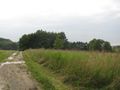
the hash lies somewhere to the right

proof1

proof2
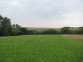
the south
the east
the north
the west
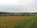
some scenery of Unterfranken
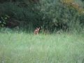
a reh


Achievements
GeorgDerReisende earned the Thumbs Up Geohash Achievement
|