Difference between revisions of "2013-08-27 49 9"
imported>GeorgDerReisende (expedition near Höchberg) |
imported>FippeBot m (Location) |
||
| (3 intermediate revisions by 2 users not shown) | |||
| Line 1: | Line 1: | ||
| + | {{meetup graticule | ||
| + | | lat=49 | ||
| + | | lon=9 | ||
| + | | date=2013-08-27 | ||
| + | | graticule_name=Würzburg | ||
| + | | graticule_link=Würzburg, Germany | ||
| + | }}__NOTOC__ | ||
| + | == Location == | ||
| − | + | Today's location is in a meadow between Höchberg, Waldbüttelbrunn and Eisingen, near Würzburg. | |
| − | + | Country: Germany; state: Bayern (Bavaria, EU:DE:BY); administrative region: Unterfranken; district: Würzburg rural district | |
| − | + | Weather: clouded | |
| − | |||
| − | |||
| − | |||
| − | |||
| − | |||
| − | |||
| − | |||
| − | |||
| − | + | == [[User:GeorgDerReisende|GeorgDerReisende]] == | |
| − | + | ||
| − | == | + | === Plans === |
| − | + | ||
| + | To go there, by hitchhiking, taking some photos, then going home, again by hitchhiking. | ||
| − | == | + | === Expedition === |
| − | |||
| − | |||
| − | + | I had calculated a travel time of about 5 1/2 hours for the way to Höchberg and the same time for the way home. With this calculation I started at the last possible time, at 11:30. I have went to the truckstop ''Lohfeldener Rüssel'' and asked there drivers, if they are going south. After 15 minutes I got a car going to the service station ''Hasselberg'', with about no waiting time I got there a car to the service station ''Großenmoor'', but there I had to wait for one hour and got then a truck to the service station ''Riedener Wald''. From there I got another car within 30 minutes to Würzburg, where I arrived at 16:45. By taking the bus and then not walking straight ahead I arrived at the hash at 18:00. There I have taken the necessary proof and pictures. Then I have walked back to Höchberg, but again not the direct way and I have taken some useless photos again. A roe deer was looking around, what I was doing there. | |
| − | |||
| − | + | I started hitchhiking at 19:40, which had been one hour behind my plan, I got a car to the service station ''Riedener Wald'', after a waiting time of one hour a car to the service station ''Hasselberg'' and after an another waiting time of 30 minutes a car to the exit ''Wilhelmshöhe'', from which I got another car for four kilometers. The last way I had to walk, so I arrived at home at about 2:45. | |
| − | |||
| − | == Tracklog == | + | === Tracklog === |
<!-- if your GPS device keeps a log, you may post a link here --> | <!-- if your GPS device keeps a log, you may post a link here --> | ||
| − | == Photos == | + | === Photos === |
| − | |||
| − | |||
| − | |||
<gallery perrow="5"> | <gallery perrow="5"> | ||
| + | Image:2013-08-27 49 9 GeorgDerReisende 8770.jpg | the hash lies somewhere to the right | ||
| + | Image:2013-08-27 49 9 GeorgDerReisende 8777.jpg | proof1 | ||
| + | Image:2013-08-27 49 9 GeorgDerReisende 8778.jpg | proof2 | ||
| + | Image:2013-08-27 49 9 GeorgDerReisende 8779.jpg | the south | ||
| + | Image:2013-08-27 49 9 GeorgDerReisende 8780.jpg | the east | ||
| + | Image:2013-08-27 49 9 GeorgDerReisende 8781.jpg | the north | ||
| + | Image:2013-08-27 49 9 GeorgDerReisende 8782.jpg | the west | ||
| + | Image:2013-08-27 49 9 GeorgDerReisende 8818.jpg | some scenery of Unterfranken | ||
| + | Image:2013-08-27 49 9 GeorgDerReisende 8832.jpg | a reh | ||
</gallery> | </gallery> | ||
| − | == Achievements == | + | === Achievements === |
{{#vardefine:ribbonwidth|800px}} | {{#vardefine:ribbonwidth|800px}} | ||
| − | + | ||
| + | {{Thumbs Up | latitude = 49 | longitude = 9 | date = 2013-08-27 | name = GeorgDerReisende }} | ||
| + | |||
| + | {{Minesweeper geohash | graticule = Mannheim, Germany | ranknumber = 2 | e = true | se = true | name = GeorgDerReisende }} | ||
| + | |||
| + | {{Minesweeper geohash | graticule = Stuttgart, Germany | ranknumber = 2 | n = true | nw = true | name = GeorgDerReisende }} | ||
| + | |||
| + | {{Minesweeper geohash | graticule = Würzburg, Germany | ranknumber = 2 | s = true | w = true | name = GeorgDerReisende }} | ||
| + | |||
| − | + | ==[[User:Danatar|Danatar]]== | |
| − | |||
| − | [[ | ||
| − | + | The weather was clouded, but it didn't look like it would rain. I had to work during the following night, which in my current job means "work 08:00 to 14:00, go home for a while, return to work from 20:30 to 08:30, rest of the second day off". I started from work at 14:25 and cycled through Würzburg to Höchberg and from there over the fields. It went well and it felt good to pass the green spots along the route. After a while I was near the hashpoint and found a meadow with many colorful flowers. Reaching the spot (at 15:08) itself was easy. Afterwards I returned to Höchberg on the same path, but from there I took a different route home. | |
| − | |||
| − | |||
| − | |||
| − | + | Only today (2013-08-31) did I see that Georg also went to the hashpoint. What a pity, I'd have liked to meet him! | |
| − | |||
| − | |||
| − | |||
| − | |||
| − | |||
| − | |||
| − | |||
| − | |||
| − | |||
| − | -- | + | <gallery> |
| − | + | File:2013-08-27_49_9_weg1.jpg| | |
| − | -- | + | File:2013-08-27_49_9_wegweiser.jpg| |
| − | + | File:2013-08-27_49_9_near1.jpg|not far now | |
| − | + | File:2013-08-27_49_9_near2.jpg|almost there | |
| − | + | File:2013-08-27_49_9_spot.jpg|the hashpoint | |
| − | + | File:2013-08-27_49_9_gps.jpg|GPS | |
| − | + | File:2013-08-27_49_9_hp.jpg|Coordinates reached! | |
| + | File:2013-08-27_49_9_pano.jpg|panorama | ||
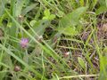
| + | File:2013-08-27_49_9_flora1.jpg| | ||
| + | File:2013-08-27_49_9_flora2.jpg| | ||
| + | File:2013-08-27_49_9_heuschrecke.jpg| | ||
| + | File:2013-08-27_49_9_nordicwalking.jpg|the routes for nordic walking near Waldbüttelbrunn. Hashpoint is on the lower edge of the map | ||
| + | </gallery> | ||
| − | + | ===tracklog=== | |
| − | [ | + | [http://www.everytrail.com/view_trip.php?trip_id=2294531&code=bc4383e46c99e2c37dc79629690baeb9 triton tracklog] |
| − | |||
| − | |||
| − | |||
| − | + | [[Category:Expeditions]] | |
| + | [[Category:Expeditions with photos]] | ||
| + | [[Category:Coordinates reached]] | ||
| + | [[Category:Danatar]] | ||
| + | {{location|DE|BY|WÜ}} | ||
Latest revision as of 03:44, 14 August 2019
| Tue 27 Aug 2013 in Würzburg: 49.7703511, 9.8435224 geohashing.info google osm bing/os kml crox |
Location
Today's location is in a meadow between Höchberg, Waldbüttelbrunn and Eisingen, near Würzburg.
Country: Germany; state: Bayern (Bavaria, EU:DE:BY); administrative region: Unterfranken; district: Würzburg rural district
Weather: clouded
GeorgDerReisende
Plans
To go there, by hitchhiking, taking some photos, then going home, again by hitchhiking.
Expedition
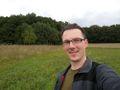
I had calculated a travel time of about 5 1/2 hours for the way to Höchberg and the same time for the way home. With this calculation I started at the last possible time, at 11:30. I have went to the truckstop Lohfeldener Rüssel and asked there drivers, if they are going south. After 15 minutes I got a car going to the service station Hasselberg, with about no waiting time I got there a car to the service station Großenmoor, but there I had to wait for one hour and got then a truck to the service station Riedener Wald. From there I got another car within 30 minutes to Würzburg, where I arrived at 16:45. By taking the bus and then not walking straight ahead I arrived at the hash at 18:00. There I have taken the necessary proof and pictures. Then I have walked back to Höchberg, but again not the direct way and I have taken some useless photos again. A roe deer was looking around, what I was doing there.
I started hitchhiking at 19:40, which had been one hour behind my plan, I got a car to the service station Riedener Wald, after a waiting time of one hour a car to the service station Hasselberg and after an another waiting time of 30 minutes a car to the exit Wilhelmshöhe, from which I got another car for four kilometers. The last way I had to walk, so I arrived at home at about 2:45.
Tracklog
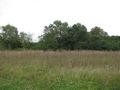
Photos
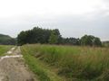
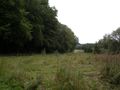
the hash lies somewhere to the right

proof1

proof2
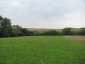
the south
the east
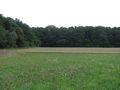
the north
the west
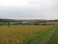
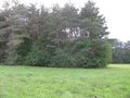
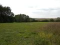
some scenery of Unterfranken
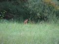
a reh


Achievements
GeorgDerReisende earned the Thumbs Up Geohash Achievement
|
GeorgDerReisende achieved level 2 of the Minesweeper Geohash achievement
|
GeorgDerReisende achieved level 2 of the Minesweeper Geohash achievement
|
GeorgDerReisende achieved level 2 of the Minesweeper Geohash achievement
|
Danatar
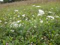
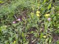
The weather was clouded, but it didn't look like it would rain. I had to work during the following night, which in my current job means "work 08:00 to 14:00, go home for a while, return to work from 20:30 to 08:30, rest of the second day off". I started from work at 14:25 and cycled through Würzburg to Höchberg and from there over the fields. It went well and it felt good to pass the green spots along the route. After a while I was near the hashpoint and found a meadow with many colorful flowers. Reaching the spot (at 15:08) itself was easy. Afterwards I returned to Höchberg on the same path, but from there I took a different route home.
Only today (2013-08-31) did I see that Georg also went to the hashpoint. What a pity, I'd have liked to meet him!

not far now
almost there
the hashpoint
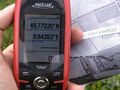
GPS
Coordinates reached!
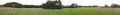
panorama
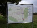
the routes for nordic walking near Waldbüttelbrunn. Hashpoint is on the lower edge of the map


