2013-08-28 52 1
| Wed 28 Aug 2013 in 52,1: 52.3385872, 1.6231009 geohashing.info google osm bing/os kml crox |
Location
In a field above Suffolk Wildlife Trust Hen Reedbeds Nature Reserve, near Wangford
Participants
Expedition
MagicIan had the week off work after the bank holiday before starting a new job, and was taking advantage of the summer sunshine by going for a nice long cycle (~60 miles round trip). It was a pleasant route mainly on quiet back roads. He stopped for a sandwich in the village of Wangford before continuing past the waste disposal site to Mardle Road adjacent to the field containing the hashpoint. He parked his bike at Suffolk Wildlife Trust Hen Reedbeds Nature Reserve and walked from there. After working out there was no access from the nature reserve he backtracked up Mardle Road and hopped into the field through a gap in the hedge by the woods. From there it was a short walk through the woods themselves, coming out ~35m from the hashpoint. He could've walked into the field to get closer but there were crops growing that he didn't want to damage. For this reason he is claiming the expedition as a success.
- Failed to reach hashpoint. -- Sourcerer (talk) @52.3365,1.6241 22:18, 28 August 2013 (GMT+01:00)
Tracklog
Photos
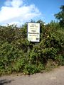
Photo taken at Suffolk Wildlife Trust Hen Reedbeds Nature Reserve near the hashpoint for Wednesday 28-08-2013, 52.338587°, 1.623100° (Norwich, United Kingdom)
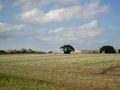
Photo taken of the waste disposal site on the way to the hashpoint for Wednesday 28-08-2013, 52.338587°, 1.623100° (Norwich, United Kingdom)
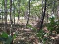
Photo taken while walking through the woods on the way to the hashpoint for Wednesday 28-08-2013, 52.338587°, 1.623100° (Norwich, United Kingdom)
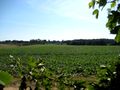
Photo of the hashpoint for Wednesday 28-08-2013, 52.338587°, 1.623100° (Norwich, United Kingdom)

Photo of phone (as it was refusing to save a screenshot) showing proximity of the hashpoint for Wednesday 28-08-2013, 52.338587°, 1.623100° (Norwich, United Kingdom)


Achievements
MagicIan earned the Bicycle geohash achievement
|