Difference between revisions of "2013-08-30 44 -117"
imported>Eldin ([live] First hash of oregon trip, success!) |
imported>FippeBot m (Location) |
||
| (One intermediate revision by one other user not shown) | |||
| Line 1: | Line 1: | ||
| − | |||
| − | |||
| − | |||
| − | |||
| − | |||
| − | |||
| − | |||
| − | |||
| − | |||
| − | |||
{{meetup graticule | {{meetup graticule | ||
| lat=44 | | lat=44 | ||
| Line 15: | Line 5: | ||
}} | }} | ||
| − | |||
__NOTOC__ | __NOTOC__ | ||
== Location == | == Location == | ||
| − | + | In the desert near Durkee, OR | |
== Participants == | == Participants == | ||
| − | + | * [[User:Eldin|Eldin]] | |
| − | |||
== Plans == | == Plans == | ||
| − | + | I was traveling from Boise, ID to Portland, OR today. So before I left I scouted hashes along the route. A number of them looked somewhat promising. This was the first (of 2) that I decided to definitely try for. | |
== Expedition == | == Expedition == | ||
| − | + | While in route to Portland, we exited the interstate at the Durkee exit. We passed by some old houses in various states of repair, and a rather old-fashioned looking church. The railings, concrete, and the bell in the tower were obviously quite old, but the building had been very recently painted and had a new roof, so it could almost fool one into believing it was newly made in an old-time style. We didn't see a single person in the very small town though. At the far edge of town, we took a gravel road which went back under the interstate to the side where the hash was located. We then left the gravel road for a dirt "road" (more like a jeep trail). About a quarter of a mile from the hash, the quality of the trail deteriorated past the threshold where my wife gets grumpy about me taking my car on it So I pulled off to the side and set out walking. I invited my wife to come along, but she elected to stay in the car instead, it being a rather hot day (~90°F). I walked the remainder of the way to the hash, posted my success to the wiki, took some photos, and headed back to the car. All told, this hash added 30-40 minutes and 2-3 miles of driving to the total length of our trip. | |
| − | |||
*First hash of oregon trip, success! -- [[User:Eldin|Eldin]] ([[User talk:Eldin|talk]]) [http://www.openstreetmap.org/?lat=44.60015067&lon=-117.46599960&zoom=16&layers=B000FTF @44.6002,-117.4660] 16:10, 30 August 2013 (MDT) | *First hash of oregon trip, success! -- [[User:Eldin|Eldin]] ([[User talk:Eldin|talk]]) [http://www.openstreetmap.org/?lat=44.60015067&lon=-117.46599960&zoom=16&layers=B000FTF @44.6002,-117.4660] 16:10, 30 August 2013 (MDT) | ||
| − | |||
| − | |||
== Photos == | == Photos == | ||
| − | |||
| − | |||
| − | |||
<gallery perrow="5"> | <gallery perrow="5"> | ||
| + | File:2013-08-30 44 -117 proof.jpg | Proof that I was in the right spot. | ||
| + | File:2013-08-30 44 -117 grin.jpg | Me, at the hashpoint. | ||
| + | File:2013-08-30 44 -117 view1.jpg | My wife stayed in the car just the other side of that hill. | ||
| + | File:2013-08-30 44 -117 view2.jpg | And the view in the oposite direction. | ||
| + | File:2013-08-30 44 -117 church.jpg | An interesting old (but recently painted) church about half a mile from the hash. | ||
</gallery> | </gallery> | ||
== Achievements == | == Achievements == | ||
{{#vardefine:ribbonwidth|800px}} | {{#vardefine:ribbonwidth|800px}} | ||
| − | + | {{Minesweeper geohash | |
| + | | graticule = Boise, Idaho | ||
| + | | ranknumber = 5 | ||
| + | | n = true | ||
| + | | ne = true | ||
| + | | e = true | ||
| + | | se = true | ||
| + | | nw = true | ||
| + | | name = [[User:Eldin|Eldin]] | ||
| + | }} | ||
| + | {{Land geohash|latitude=44|longitude=-117|date=2013-08-30|name=[[User:Eldin|Eldin]]}} | ||
| − | |||
| − | |||
| − | |||
| − | |||
| − | |||
| − | |||
| − | |||
| − | |||
| − | |||
| − | |||
| − | |||
[[Category:Expeditions]] | [[Category:Expeditions]] | ||
| − | |||
[[Category:Expeditions with photos]] | [[Category:Expeditions with photos]] | ||
| − | |||
| − | |||
| − | |||
| − | |||
| − | |||
[[Category:Coordinates reached]] | [[Category:Coordinates reached]] | ||
| − | + | {{location|US|OR|BA}} | |
| − | |||
| − | |||
| − | |||
| − | |||
| − | |||
| − | |||
| − | |||
| − | |||
| − | |||
| − | |||
| − | |||
| − | |||
| − | |||
| − | |||
| − | |||
| − | |||
| − | |||
Latest revision as of 06:27, 6 August 2019
| Fri 30 Aug 2013 in 44,-117: 44.6001421, -117.4660292 geohashing.info google osm bing/os kml crox |
Location
In the desert near Durkee, OR
Participants
Plans
I was traveling from Boise, ID to Portland, OR today. So before I left I scouted hashes along the route. A number of them looked somewhat promising. This was the first (of 2) that I decided to definitely try for.
Expedition
While in route to Portland, we exited the interstate at the Durkee exit. We passed by some old houses in various states of repair, and a rather old-fashioned looking church. The railings, concrete, and the bell in the tower were obviously quite old, but the building had been very recently painted and had a new roof, so it could almost fool one into believing it was newly made in an old-time style. We didn't see a single person in the very small town though. At the far edge of town, we took a gravel road which went back under the interstate to the side where the hash was located. We then left the gravel road for a dirt "road" (more like a jeep trail). About a quarter of a mile from the hash, the quality of the trail deteriorated past the threshold where my wife gets grumpy about me taking my car on it So I pulled off to the side and set out walking. I invited my wife to come along, but she elected to stay in the car instead, it being a rather hot day (~90°F). I walked the remainder of the way to the hash, posted my success to the wiki, took some photos, and headed back to the car. All told, this hash added 30-40 minutes and 2-3 miles of driving to the total length of our trip.
- First hash of oregon trip, success! -- Eldin (talk) @44.6002,-117.4660 16:10, 30 August 2013 (MDT)
Photos
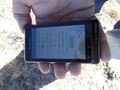
Proof that I was in the right spot.

Me, at the hashpoint.
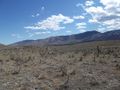
My wife stayed in the car just the other side of that hill.
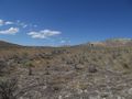
And the view in the oposite direction.
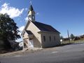
An interesting old (but recently painted) church about half a mile from the hash.


Achievements
Eldin achieved level 5 of the Minesweeper Geohash achievement
|
Eldin earned the Land geohash achievement
|