Difference between revisions of "2013-09-02 45 -123"
From Geohashing
imported>Eldin ([retro] Not reached due to excessively steep terrain. Pics and writeup will follow.) |
imported>FippeBot m (Location) |
||
| (2 intermediate revisions by 2 users not shown) | |||
| Line 1: | Line 1: | ||
| − | |||
| − | |||
| − | |||
| − | |||
| − | |||
| − | |||
| − | |||
| − | |||
| − | |||
| − | |||
{{meetup graticule | {{meetup graticule | ||
| lat=45 | | lat=45 | ||
| Line 15: | Line 5: | ||
}} | }} | ||
| − | |||
__NOTOC__ | __NOTOC__ | ||
== Location == | == Location == | ||
| − | + | In the forest northeast of Garibaldi. | |
== Participants == | == Participants == | ||
| − | + | * [[User:Eldin|Eldin]] | |
| − | + | * Eldin's dad | |
| − | |||
| − | |||
== Expedition == | == Expedition == | ||
| − | + | I set out for the hashpoint after seeing that it appeared to be on public land not too distant from where we were staying in Oregon. I was accompanied by my dad. We were able to drive to within about 1.7 miles of the hashpoint. We then got out and walked for a bit along the road. At our closest approach, we were about 1.2 miles from the hash. But unable to find any road or trail which went closer to the hash, we decided that bushwhacking over a mile over steep terrain was more effort and time than we were willing to expend for this expedition. | |
| − | |||
*Not reached due to excessively steep terrain. Pics and writeup will follow. -- [[User:Eldin|Eldin]] ([[User talk:Eldin|talk]]) [http://www.openstreetmap.org/?lat=45.61046488&lon=-123.94426373&zoom=16&layers=B000FTF @45.6105,-123.9443] 10:31, 3 September 2013 (PDT) | *Not reached due to excessively steep terrain. Pics and writeup will follow. -- [[User:Eldin|Eldin]] ([[User talk:Eldin|talk]]) [http://www.openstreetmap.org/?lat=45.61046488&lon=-123.94426373&zoom=16&layers=B000FTF @45.6105,-123.9443] 10:31, 3 September 2013 (PDT) | ||
| − | |||
| − | |||
== Photos == | == Photos == | ||
| − | |||
| − | |||
| − | |||
<gallery perrow="5"> | <gallery perrow="5"> | ||
| + | File:2013-09-02 45 -123 tree1.JPG | [[User:Eldin|Eldin]] standing under a fallen tree at about the point where we gave up. | ||
| + | File:2013-09-02 45 -123 tree2.JPG | Eldin's dad standing under the same tree. | ||
| + | File:2013-09-02 45 -123 terrain.JPG | The hash was a bit over a mile through that. | ||
</gallery> | </gallery> | ||
== Achievements == | == Achievements == | ||
| − | |||
| − | |||
| + | * MNB | ||
| − | |||
| − | |||
| − | |||
| − | |||
| − | |||
| − | |||
| − | |||
| − | |||
| − | |||
| − | |||
[[Category:Expeditions]] | [[Category:Expeditions]] | ||
| − | |||
[[Category:Expeditions with photos]] | [[Category:Expeditions with photos]] | ||
| − | |||
| − | |||
| − | |||
| − | |||
| − | |||
| − | |||
| − | |||
| − | |||
| − | |||
[[Category:Coordinates not reached]] | [[Category:Coordinates not reached]] | ||
| − | |||
| − | |||
[[Category:Not reached - Mother Nature]] | [[Category:Not reached - Mother Nature]] | ||
| − | + | {{location|US|OR|TI}} | |
| − | |||
| − | |||
| − | |||
| − | |||
| − | |||
| − | |||
| − | |||
| − | |||
| − | |||
| − | |||
Latest revision as of 03:49, 14 August 2019
| Mon 2 Sep 2013 in 45,-123: 45.6028551, -123.8134778 geohashing.info google osm bing/os kml crox |
Location
In the forest northeast of Garibaldi.
Participants
- Eldin
- Eldin's dad
Expedition
I set out for the hashpoint after seeing that it appeared to be on public land not too distant from where we were staying in Oregon. I was accompanied by my dad. We were able to drive to within about 1.7 miles of the hashpoint. We then got out and walked for a bit along the road. At our closest approach, we were about 1.2 miles from the hash. But unable to find any road or trail which went closer to the hash, we decided that bushwhacking over a mile over steep terrain was more effort and time than we were willing to expend for this expedition.
- Not reached due to excessively steep terrain. Pics and writeup will follow. -- Eldin (talk) @45.6105,-123.9443 10:31, 3 September 2013 (PDT)
Photos
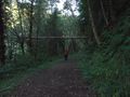
Eldin standing under a fallen tree at about the point where we gave up.
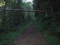
Eldin's dad standing under the same tree.
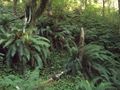
The hash was a bit over a mile through that.


Achievements
- MNB