Difference between revisions of "2013-09-02 48 8"
From Geohashing
imported>Hulmgulm (→Expedition) |
imported>Jiml m (Adjust result codes) |
||
| Line 15: | Line 15: | ||
}} | }} | ||
| − | + | ||
__NOTOC__ | __NOTOC__ | ||
== Location == | == Location == | ||
| − | + | ||
The location is in the middle of a field near Kuppingen. | The location is in the middle of a field near Kuppingen. | ||
== Participants == | == Participants == | ||
| − | + | ||
| − | + | * [[User:Hulmgulm|Hulmgulm]] | |
| − | [[User:Hulmgulm|Hulmgulm]] | ||
== Plans == | == Plans == | ||
| Line 30: | Line 29: | ||
== Expedition == | == Expedition == | ||
| − | + | ||
I drove my car from Kuppingen and parked it at the "no entry" sign. Then I walked across the field to the coordinates. | I drove my car from Kuppingen and parked it at the "no entry" sign. Then I walked across the field to the coordinates. | ||
Afterwards I spent more than one hour looking for four geocaches. | Afterwards I spent more than one hour looking for four geocaches. | ||
| Line 38: | Line 37: | ||
== Photos == | == Photos == | ||
| − | + | ||
| − | |||
| − | |||
<gallery perrow="5"> | <gallery perrow="5"> | ||
Image:IMG 20130902 115251.jpg | Log proof | Image:IMG 20130902 115251.jpg | Log proof | ||
| Line 50: | Line 47: | ||
<!-- Add any achievement ribbons you earned below, or remove this section --> | <!-- Add any achievement ribbons you earned below, or remove this section --> | ||
| + | * Land geohash | ||
| − | |||
| − | |||
| − | |||
| − | + | [[Category:Expeditions]] | |
| − | |||
| − | [[Category: | ||
| − | |||
| − | |||
| − | |||
| − | |||
[[Category:Expeditions with photos]] | [[Category:Expeditions with photos]] | ||
| − | |||
| − | |||
| − | |||
| − | |||
| − | |||
[[Category:Coordinates reached]] | [[Category:Coordinates reached]] | ||
| − | |||
| − | |||
| − | |||
| − | |||
| − | |||
| − | |||
| − | |||
| − | |||
| − | |||
| − | |||
| − | |||
| − | |||
| − | |||
| − | |||
| − | |||
| − | |||
| − | |||
| − | |||
Revision as of 21:49, 2 September 2013
| Mon 2 Sep 2013 in 48,8: 48.6028551, 8.8134778 geohashing.info google osm bing/os kml crox |
Location
The location is in the middle of a field near Kuppingen.
Participants
Plans
Expedition
I drove my car from Kuppingen and parked it at the "no entry" sign. Then I walked across the field to the coordinates. Afterwards I spent more than one hour looking for four geocaches.
Tracklog
Photos
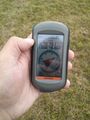
Log proof
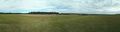
Panorama at the location

Achievements
- Land geohash