Difference between revisions of "2013-09-02 53 -1"
From Geohashing
imported>Mampfred (Created page with "{{subst:Expedition |lat = 53 |lon = -1 |date = 2013-09-02 }}") |
imported>FippeBot m (Location) |
||
| (2 intermediate revisions by one other user not shown) | |||
| Line 1: | Line 1: | ||
| − | |||
| − | |||
| − | |||
| − | |||
| − | |||
| − | |||
| − | |||
| − | |||
| − | |||
| − | |||
{{meetup graticule | {{meetup graticule | ||
| lat=53 | | lat=53 | ||
| Line 15: | Line 5: | ||
}} | }} | ||
| − | |||
__NOTOC__ | __NOTOC__ | ||
== Location == | == Location == | ||
| − | + | On the street in front of a cottage in Honley, West Yorkshire. | |
== Participants == | == Participants == | ||
| − | + | * [[User:Mampfred|Mampfred]] | |
| − | |||
== Plans == | == Plans == | ||
| − | + | Might make a detour coming from the Manchester airport. ETA arount 7pm. | |
== Expedition == | == Expedition == | ||
| − | < | + | Totally worth it. I altered my usual way through the midlands and went a bit further north across the <insert name here> summit. A lot of fun especially since the other route was very busy tonight due to an accident. |
| + | |||
| + | The hash took me to a very bad road leading to some cottages at the end of a dead end. I parked all the way at the end and walked back 70 meters. On the way back I probably even drove through the hash. | ||
== Tracklog == | == Tracklog == | ||
| − | + | See [http://www.everytrail.com/tell_story.php?trip_id=2299539 here]. | |
== Photos == | == Photos == | ||
| − | |||
| − | |||
| − | |||
<gallery perrow="5"> | <gallery perrow="5"> | ||
| + | Image:2013-09-02_53_-1_coordinates_reached.jpg | Coordinates reached | ||
| + | Image:2013-09-02_53_-1_hash_car.jpg | Hash car at the end of the road | ||
| + | Image:2013-09-02_53_-1_sign_to_some_woods.jpg | Entrance to some wood at the end of the road, no time for that | ||
| + | Image:2013-09-02_53_-1_the_hash.jpg | The hash | ||
| + | Image:2013-09-02_53_-1_the_hasher.jpg | The hasher in front of the hash | ||
</gallery> | </gallery> | ||
== Achievements == | == Achievements == | ||
{{#vardefine:ribbonwidth|800px}} | {{#vardefine:ribbonwidth|800px}} | ||
| − | + | * Consecutive * 2 | |
| − | |||
| − | |||
| − | |||
| − | |||
| − | |||
| − | |||
| − | |||
| − | |||
| − | |||
| − | |||
| − | |||
[[Category:Expeditions]] | [[Category:Expeditions]] | ||
| − | |||
[[Category:Expeditions with photos]] | [[Category:Expeditions with photos]] | ||
| − | |||
| − | |||
| − | |||
| − | |||
| − | |||
[[Category:Coordinates reached]] | [[Category:Coordinates reached]] | ||
| − | + | {{location|GB|ENG|KIR}} | |
| − | |||
| − | |||
| − | |||
| − | |||
| − | |||
| − | |||
| − | |||
| − | |||
| − | |||
| − | |||
| − | |||
| − | |||
| − | |||
| − | |||
| − | |||
| − | |||
| − | |||
Latest revision as of 06:31, 6 August 2019
| Mon 2 Sep 2013 in 53,-1: 53.6028551, -1.8134778 geohashing.info google osm bing/os kml crox |
Location
On the street in front of a cottage in Honley, West Yorkshire.
Participants
Plans
Might make a detour coming from the Manchester airport. ETA arount 7pm.
Expedition
Totally worth it. I altered my usual way through the midlands and went a bit further north across the <insert name here> summit. A lot of fun especially since the other route was very busy tonight due to an accident.
The hash took me to a very bad road leading to some cottages at the end of a dead end. I parked all the way at the end and walked back 70 meters. On the way back I probably even drove through the hash.
Tracklog
See here.
Photos
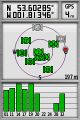
Coordinates reached
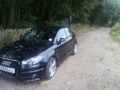
Hash car at the end of the road
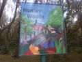
Entrance to some wood at the end of the road, no time for that
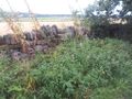
The hash
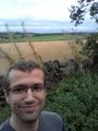
The hasher in front of the hash


Achievements
- Consecutive * 2