Difference between revisions of "2013-09-08 50 13"
From Geohashing
imported>Die Wildensteiner (→Photos) |
imported>FippeBot m (Location) |
||
| Line 56: | Line 56: | ||
[[Category:Expeditions with photos]] | [[Category:Expeditions with photos]] | ||
[[Category:Coordinates reached]] | [[Category:Coordinates reached]] | ||
| + | {{location|DE|SN|FG}} | ||
Latest revision as of 03:55, 14 August 2019
| Sun 8 Sep 2013 in 50,13: 50.8004840, 13.0880283 geohashing.info google osm bing/os kml crox |
Location
In the forest near the Castle Augustusburg.
Participants
Expedition
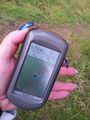
I started my walk at N 50 47.887 E 013 05.519. Then I went downhill for about 400 meters.
It was hard to get to the exact position, because the hillside near the path was really rampant. But after 30 minutes I did it.
Photos
Lange Suche mit Erfolg
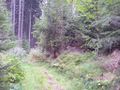
Beim Anmarsch

mit Exif-Datum für log proof


Achievements
Die Wildensteiner earned the Land geohash achievement
|