Difference between revisions of "2013-09-13 40 -74"
imported>Jevanyn ([live picture] Nice hillside view to the northwest [http://www.openstreetmap.org/?lat=40.47334300&lon=-74.87821890&zoom=16&layers=B000FTF @40.4733,-74.8782]) |
imported>FippeBot m (Location) |
||
| (2 intermediate revisions by one other user not shown) | |||
| Line 1: | Line 1: | ||
| − | |||
| − | |||
| − | |||
| − | |||
| − | |||
| − | |||
| − | |||
| − | |||
| − | |||
{{meetup graticule | {{meetup graticule | ||
| lat=40 | | lat=40 | ||
| Line 18: | Line 9: | ||
__NOTOC__ | __NOTOC__ | ||
== Location == | == Location == | ||
| − | + | Flemington | |
== Participants == | == Participants == | ||
| − | + | *[[User:Jevanyn|Team Jevanyn]] | |
| − | |||
== Plans == | == Plans == | ||
| − | + | Home early from work at AT&T, because I was resigning to take a new job at Picatinny Arsenal. (Which will probably cause your neck to whiplash, if you've been following my employment record of late.) The geohash was in Flemington, a reachable spot about 10 miles or so from home, so I drove us all down. | |
== Expedition == | == Expedition == | ||
| − | + | *I had a short day at work (more on that later) and stopped by Flemington for the geohash. It should be ten feet of the side of the road from where we parked. -- [[User:Jevanyn|Jevanyn]] ([[User talk:Jevanyn|talk]]) [http://www.openstreetmap.org/?lat=40.47322214&lon=-74.87747266&zoom=16&layers=B000FTF @40.4732,-74.8775] 13:48, 13 September 2013 (EDT) | |
| − | |||
*Closest approach is here, inside the margin of error. Long time no geohash, nice to have a chance to do this again :-) -- [[User:Jevanyn|Jevanyn]] ([[User talk:Jevanyn|talk]]) [http://www.openstreetmap.org/?lat=40.47317812&lon=-74.87726932&zoom=16&layers=B000FTF @40.4732,-74.8773] 13:55, 13 September 2013 (EDT) | *Closest approach is here, inside the margin of error. Long time no geohash, nice to have a chance to do this again :-) -- [[User:Jevanyn|Jevanyn]] ([[User talk:Jevanyn|talk]]) [http://www.openstreetmap.org/?lat=40.47317812&lon=-74.87726932&zoom=16&layers=B000FTF @40.4732,-74.8773] 13:55, 13 September 2013 (EDT) | ||
| − | |||
| − | |||
== Photos == | == Photos == | ||
| − | + | I still haven't figured out how to tell my phone that photographs need to be rotated ''in the file'', so that when they're shared they're right-side up. it thinks as long as it rotates them ''on the screen'' that's enough #firstworldproblems. | |
| − | |||
| − | |||
<gallery perrow="5"> | <gallery perrow="5"> | ||
| Line 50: | Line 35: | ||
</gallery> | </gallery> | ||
| − | |||
| − | |||
| − | |||
| − | |||
| − | |||
| − | |||
| − | |||
| − | |||
| − | |||
| − | |||
| − | |||
| − | |||
| − | |||
| − | |||
| − | |||
[[Category:Expeditions]] | [[Category:Expeditions]] | ||
| − | |||
[[Category:Expeditions with photos]] | [[Category:Expeditions with photos]] | ||
| − | |||
| − | |||
| − | |||
| − | |||
| − | |||
[[Category:Coordinates reached]] | [[Category:Coordinates reached]] | ||
| − | + | {{location|US|NJ|HN}} | |
| − | |||
| − | |||
| − | |||
| − | |||
| − | |||
| − | |||
| − | |||
| − | |||
| − | |||
| − | |||
| − | |||
| − | |||
| − | |||
| − | |||
| − | |||
| − | |||
| − | |||
Latest revision as of 03:58, 14 August 2019
| Fri 13 Sep 2013 in 40,-74: 40.4731319, -74.8772739 geohashing.info google osm bing/os kml crox |
Location
Flemington
Participants
Plans
Home early from work at AT&T, because I was resigning to take a new job at Picatinny Arsenal. (Which will probably cause your neck to whiplash, if you've been following my employment record of late.) The geohash was in Flemington, a reachable spot about 10 miles or so from home, so I drove us all down.
Expedition
- I had a short day at work (more on that later) and stopped by Flemington for the geohash. It should be ten feet of the side of the road from where we parked. -- Jevanyn (talk) @40.4732,-74.8775 13:48, 13 September 2013 (EDT)
- Closest approach is here, inside the margin of error. Long time no geohash, nice to have a chance to do this again :-) -- Jevanyn (talk) @40.4732,-74.8773 13:55, 13 September 2013 (EDT)
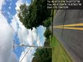
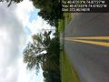
Photos
I still haven't figured out how to tell my phone that photographs need to be rotated in the file, so that when they're shared they're right-side up. it thinks as long as it rotates them on the screen that's enough #firstworldproblems.

Closest intersection, plus a silly face @40.4732,-74.8784
The view east (I'll fix the orientation when I get to a real computer) @40.4733,-74.8782
The view west (ibid) @40.4733,-74.8782
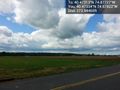
Nice hillside view to the northwest @40.4733,-74.8782


