Difference between revisions of "2013-09-15 45 -123"
imported>Michael5000 m (→Expedition) |
imported>Frogman (→Photos) |
||
| Line 44: | Line 44: | ||
--> | --> | ||
<gallery perrow="5"> | <gallery perrow="5"> | ||
| + | Image:2013-09-15 45 -123 thickbrush.jpg | An example of the terrain we were required to traverse. | ||
| + | Image:2013-09-15 45 -123 searching.jpg | [[User:Michael5000 | Michael5000]] searching for the exact point. | ||
| + | Image:2013-09-15 45 -123 proof.jpg | A little blurry, but here's the proof! | ||
| + | Image:2013-09-15 45 -123 thehashpoint.jpg | The hashpoint, roughly. | ||
| + | Image:2013-09-15 45 -123 marker.jpg | We left a marker in case any other intrepid adventurers came by. | ||
| + | Image:2013-09-15 45 -123 highwayrightofway.jpg | We found a highway right-of-way sign near the hashpoint. | ||
</gallery> | </gallery> | ||
Revision as of 23:40, 15 September 2013
| Sun 15 Sep 2013 in 45,-123: 45.6707949, -123.1776052 geohashing.info google osm bing/os kml crox |
Location
In the woods off Highway 26, near an ODOT station.
Participants
Plans
Here goes nothing. Michael5000 and Frogman will attempt the hashpoint from Hwy 26 a little after 11 a.m., then head for the Banks/Vernonia Trail.
Expedition
A challenging hashpoint! After driving through a rare Oregon lightning storm west out of Portland, we parked close to the ODOT facility gate, then walked east again heavy traffic on the shoulder of US 26 to get past a swampy area. As it turned out, the problem wasn't swamp, it was a surprisingly steep slope of 1 to 1 or more, upwards through thick forest and windfall. It was a walk of only about 600 feet from the highway, but until close to the end every foot was purchased with quite a bit of exertion.
Once we were at the top, it looked like there might be a more gradual way back down if we took the long way behind and to the east of the ODOT station. That worked like a charm -- highly recommended if anybody makes a late-day stab at this one -- and soon we were celebrating Frogman's conquest of the McMinnville graticule and Washington County, and heading off for a run on the Banks-Vernonia Trail.
Tracklog
Photos
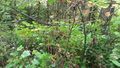
An example of the terrain we were required to traverse.
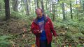
Michael5000 searching for the exact point.
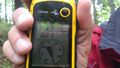
A little blurry, but here's the proof!
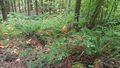
The hashpoint, roughly.
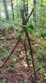
We left a marker in case any other intrepid adventurers came by.
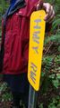
We found a highway right-of-way sign near the hashpoint.


Achievements