Difference between revisions of "2013-09-17 43 -116"
imported>Eldin (initial planning page.) |
imported>FippeBot m (Location) |
||
| (3 intermediate revisions by one other user not shown) | |||
| Line 1: | Line 1: | ||
| − | |||
| − | |||
| − | |||
| − | |||
| − | |||
| − | |||
| − | |||
| − | |||
| − | |||
| − | |||
{{meetup graticule | {{meetup graticule | ||
| lat=43 | | lat=43 | ||
| Line 15: | Line 5: | ||
}} | }} | ||
| − | |||
__NOTOC__ | __NOTOC__ | ||
== Location == | == Location == | ||
| − | in the desert, | + | in the desert, south of Hwy 21, east of Micron. |
== Participants == | == Participants == | ||
| Line 28: | Line 17: | ||
== Expedition == | == Expedition == | ||
| − | + | I got a late start, since I didn't get out of the office until about 6:15 (I'd anticipated getting off closer to 5:00). But set out for the hashpoint anyway. I found a spot to park almost a mile from the coordinates, and set out walking through a new subdivision. A few houses looked occupied, but mostly under construction or empty lots. Past the subdivision, I continued out into the desert. I saw some antelope, which were very near the coordinates, but they ran off before I got close. When I reached the hash, it was in an odd area of dead vegetation. Now, most of the grass as far as the eye could see was the yellow color that grass gets this time of year. But in this area it was grey, like it was really dead. And all of the other plants in this area were either dead or sick looking. I don't know what caused it, but it was definitely a bit creepy. | |
| − | |||
| + | *A bit late, but made it! -- [[User:Eldin|Eldin]] ([[User talk:Eldin|talk]]) [http://www.openstreetmap.org/?lat=43.51955743&lon=-116.09958733&zoom=16&layers=B000FTF @43.5196,-116.0996] 19:24, 17 September 2013 (MDT) | ||
== Photos == | == Photos == | ||
| − | |||
| − | |||
| − | |||
<gallery perrow="5"> | <gallery perrow="5"> | ||
| + | File:2013-09-17 43 -116 proof.jpg | Evidence that the hash was reached, | ||
| + | File:2013-09-17 43 -116 grin.jpg | and evidence of a grinning hasher. | ||
| + | File:2013-09-17 43 -116 point.jpg | Dead vegitation at the hash. | ||
| + | File:2013-09-17 43 -116 transition.jpg | You can see here the transition between the sickly-dead vegitation at the hash and the not-sickly vegetation that was found throughout the surrounding area here. | ||
</gallery> | </gallery> | ||
== Achievements == | == Achievements == | ||
{{#vardefine:ribbonwidth|800px}} | {{#vardefine:ribbonwidth|800px}} | ||
| − | + | {{Land geohash|date=2013-09-17|latitude=43|longitude=-116|name=[[User:Eldin|Eldin]]}} | |
| − | |||
| − | |||
| − | |||
| − | |||
| − | |||
| − | |||
| − | |||
| − | |||
| − | |||
| − | |||
[[Category:Expeditions]] | [[Category:Expeditions]] | ||
| − | |||
[[Category:Expeditions with photos]] | [[Category:Expeditions with photos]] | ||
| − | |||
| − | |||
| − | |||
| − | |||
| − | |||
[[Category:Coordinates reached]] | [[Category:Coordinates reached]] | ||
| − | + | {{location|US|ID|AA}} | |
| − | |||
| − | |||
| − | |||
| − | |||
| − | |||
| − | |||
| − | |||
| − | |||
| − | |||
| − | |||
| − | |||
| − | |||
| − | |||
| − | |||
| − | |||
| − | |||
| − | |||
Latest revision as of 04:01, 14 August 2019
| Tue 17 Sep 2013 in 43,-116: 43.5195601, -116.0995852 geohashing.info google osm bing/os kml crox |
Location
in the desert, south of Hwy 21, east of Micron.
Participants
Plans
This looks like it may be accessible. Eldin plans to attempt to reach this point after work,6pm-ish.
Expedition
I got a late start, since I didn't get out of the office until about 6:15 (I'd anticipated getting off closer to 5:00). But set out for the hashpoint anyway. I found a spot to park almost a mile from the coordinates, and set out walking through a new subdivision. A few houses looked occupied, but mostly under construction or empty lots. Past the subdivision, I continued out into the desert. I saw some antelope, which were very near the coordinates, but they ran off before I got close. When I reached the hash, it was in an odd area of dead vegetation. Now, most of the grass as far as the eye could see was the yellow color that grass gets this time of year. But in this area it was grey, like it was really dead. And all of the other plants in this area were either dead or sick looking. I don't know what caused it, but it was definitely a bit creepy.
- A bit late, but made it! -- Eldin (talk) @43.5196,-116.0996 19:24, 17 September 2013 (MDT)
Photos

Evidence that the hash was reached,

and evidence of a grinning hasher.
Dead vegitation at the hash.
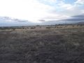
You can see here the transition between the sickly-dead vegitation at the hash and the not-sickly vegetation that was found throughout the surrounding area here.


Achievements
Eldin earned the Land geohash achievement
|