Difference between revisions of "2013-09-19 52 9"
imported>GeorgDerReisende (new expedition to Wedemark) |
imported>GeorgDerReisende (expedition report added) |
||
| Line 20: | Line 20: | ||
== Expedition == | == Expedition == | ||
| − | + | ||
| + | I have left home at 11:00, waited at my spot for about an hour, waited again at the service stations ''Göttingen'' and ''Harz'' and at last I got a lift to the junction of Mellendorf, where I arrived at 17:00. Which is one and a half hours more than I had planned for this journey. From there I have walked to the hash, through forests and along fields, walked along a street over the motorway. Then I made a turn to the right (the street does a turn to the left there) and found me near the hash, but I couldn't find the forest streets, which Google's maps show. So I stumbled through the pathless forest to the hash — and I have found it. But where had been the way out? Of course, I have a GPS-receiver so it is no problem at all. I have found the way out of the forest, made my way on another forest roads and ended at last at the truckstop of Gailhof. I arrived there at 19:40. I needed about an hour to get a car onto the motorway, with this car I got a lift to the service station ''Allertal'', which is north of Gailhof and from there a Jaguar to the service station ''Göttingen'' and from there a third car to a motorway parking place above Kassel. I arrived there at 23:20. But I couldn't get the bus from the nearby bus stop, because the bus had been one minute too early! So I went home from there, but for 2 1/2 kilometers I could get another bus, but then I had to walk again and arrived at home at 0:40. So I needed for my way home five hours, but I had a longer journey because of the detour to Allertal. | ||
== Tracklog == | == Tracklog == | ||
| Line 26: | Line 27: | ||
== Photos == | == Photos == | ||
| − | |||
| − | |||
| − | |||
<gallery perrow="5"> | <gallery perrow="5"> | ||
| + | Image:2013-09-19 52 9 GeorgDerReisende 0482.jpg | the start of the search | ||
| + | Image:2013-09-19 52 9 GeorgDerReisende 0498.jpg | climbing a bridge | ||
| + | Image:2013-09-19 52 9 GeorgDerReisende 0503.jpg | crossing the motorway | ||
| + | Image:2013-09-19 52 9 GeorgDerReisende 0506.jpg | going to the right | ||
| + | Image:2013-09-19 52 9 GeorgDerReisende 0510.jpg | there shall be a way | ||
| + | Image:2013-09-19 52 9 GeorgDerReisende 0511.jpg | somewhere next to the hash | ||
| + | Image:2013-09-19 52 9 GeorgDerReisende 0514.jpg | that is the way! | ||
| + | Image:2013-09-19 52 9 GeorgDerReisende 0520.jpg | proof1 | ||
| + | Image:2013-09-19 52 9 GeorgDerReisende 0523.jpg | the north | ||
| + | Image:2013-09-19 52 9 GeorgDerReisende 0524.jpg | the west | ||
| + | Image:2013-09-19 52 9 GeorgDerReisende 0525.jpg | the south | ||
| + | Image:2013-09-19 52 9 GeorgDerReisende 0526.jpg | and the east, what is the difference? | ||
| + | Image:2013-09-19 52 9 GeorgDerReisende 0529.jpg | proof2 | ||
| + | Image:2013-09-19 52 9 GeorgDerReisende 0531.jpg | where is the way out? | ||
| + | Image:2013-09-19 52 9 GeorgDerReisende 0535.jpg | this is the way out | ||
| + | Image:2013-09-19 52 9 GeorgDerReisende 0538.jpg | the internet was here | ||
| + | Image:2013-09-19 52 9 GeorgDerReisende 0540.jpg | grin | ||
| + | Image:2013-09-19 52 9 GeorgDerReisende 0545.jpg | the small river Wietze nearby | ||
| + | Image:2013-09-19 52 9 GeorgDerReisende 0585.jpg | interesting architecture in Gailhof | ||
| + | Image:2013-09-19 52 9 GeorgDerReisende 0598.jpg | to the left: the truckstop of Gailhof; in the middle: the street to Gailhof | ||
</gallery> | </gallery> | ||
| Line 36: | Line 54: | ||
<!-- Add any achievement ribbons you earned below, or remove this section --> | <!-- Add any achievement ribbons you earned below, or remove this section --> | ||
| + | {{Thumbs Up | latitude = 52 | longitude = 9 | date = 2013-09-19 | name = GeorgDerReisende }} | ||
| − | + | [[Category:Expeditions]] | |
| − | |||
| − | [[Category: | ||
| − | + | [[Category:Expeditions with photos]] | |
| − | |||
| − | [[Category: | ||
| − | |||
| − | |||
| − | |||
| − | |||
| − | |||
| − | |||
| − | |||
| − | |||
| − | |||
| − | |||
[[Category:Coordinates reached]] | [[Category:Coordinates reached]] | ||
| − | |||
| − | |||
| − | |||
| − | |||
| − | |||
| − | |||
| − | |||
| − | |||
| − | |||
| − | |||
| − | |||
| − | |||
| − | |||
| − | |||
| − | |||
| − | |||
| − | |||
| − | |||
Revision as of 23:54, 19 September 2013
| Thu 19 Sep 2013 in 52,9: 52.5359765, 9.8002534 geohashing.info google osm bing/os kml crox |
Location
The hash lies in a small forest south of the interchange between the motorways A7 and A352 in the communal area of Wedemark, Germany.
Participants
Plans
I will go there by hitchhiking, walking to the hash, then travel back to Kassel, maybe a stop in Hannover.
Expedition
I have left home at 11:00, waited at my spot for about an hour, waited again at the service stations Göttingen and Harz and at last I got a lift to the junction of Mellendorf, where I arrived at 17:00. Which is one and a half hours more than I had planned for this journey. From there I have walked to the hash, through forests and along fields, walked along a street over the motorway. Then I made a turn to the right (the street does a turn to the left there) and found me near the hash, but I couldn't find the forest streets, which Google's maps show. So I stumbled through the pathless forest to the hash — and I have found it. But where had been the way out? Of course, I have a GPS-receiver so it is no problem at all. I have found the way out of the forest, made my way on another forest roads and ended at last at the truckstop of Gailhof. I arrived there at 19:40. I needed about an hour to get a car onto the motorway, with this car I got a lift to the service station Allertal, which is north of Gailhof and from there a Jaguar to the service station Göttingen and from there a third car to a motorway parking place above Kassel. I arrived there at 23:20. But I couldn't get the bus from the nearby bus stop, because the bus had been one minute too early! So I went home from there, but for 2 1/2 kilometers I could get another bus, but then I had to walk again and arrived at home at 0:40. So I needed for my way home five hours, but I had a longer journey because of the detour to Allertal.
Tracklog
Photos
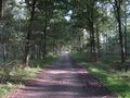
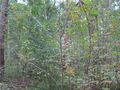
the start of the search
climbing a bridge
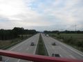
crossing the motorway
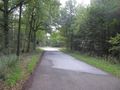
going to the right
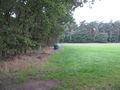
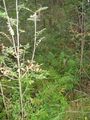
there shall be a way
somewhere next to the hash
that is the way!
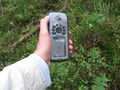
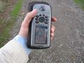
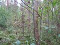
proof1
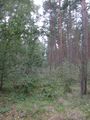
the north
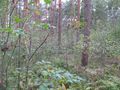
the west
the south
and the east, what is the difference?
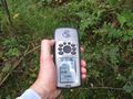
proof2
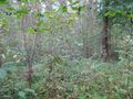
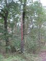
where is the way out?

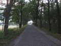
this is the way out
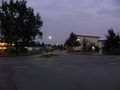
the internet was here
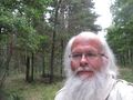
grin
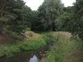
the small river Wietze nearby
interesting architecture in Gailhof
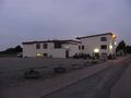
to the left: the truckstop of Gailhof; in the middle: the street to Gailhof


Achievements
GeorgDerReisende earned the Thumbs Up Geohash Achievement
|