Difference between revisions of "2013-09-23 39 -120"
imported>Zebburkeconte |
imported>Zebburkeconte |
||
| Line 45: | Line 45: | ||
| − | |||
| − | |||
| − | |||
| − | |||
| − | |||
| − | |||
| − | |||
| − | |||
| − | |||
| − | |||
[[Category:Expeditions]] | [[Category:Expeditions]] | ||
| − | + | [[Category:Expeditions with photos]] | |
| − | [[Category:Expeditions with photos]] | ||
| − | |||
| − | |||
| − | |||
| − | |||
| − | |||
[[Category:Coordinates reached]] | [[Category:Coordinates reached]] | ||
| − | |||
| − | |||
| − | |||
| − | |||
| − | |||
| − | |||
| − | |||
| − | |||
| − | |||
| − | |||
| − | |||
| − | |||
| − | |||
| − | |||
| − | |||
| − | |||
| − | |||
| − | |||
Revision as of 02:48, 24 September 2013
| Mon 23 Sep 2013 in 39,-120: 39.3960634, -120.0279539 geohashing.info google osm bing/os kml crox |
Location
Originally surveyed to be just up a slight hill off of Highway 80. Upon arrival, it became clear that it was up a MOUNTAIN.
Participants
Zebburkeconte (talk) and Zebburkeconte (talk)'s dad
Plans
Almost none. Drive there and scope it out.
Expedition
When we got there it quickly became apparent that the elevation gain was much steeper than it had been surveyed to be. However, we still attempted it and managed to climb up the entire way with great difficulty. Once we got there, however, the GPS on the iPhone we were using started to glitch out, jumping all around. We eventually used satellite images in absence of a reliable GPS in order to pinpoint the spot, and we made it. During the GPS glitching, it did get it correct a few times, and we quickly screen captured as proof.
Photos

Stupid Grin!

We did it!
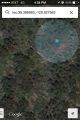
Within margin of error with glitchy GPS
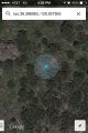
Also within margin of error (blue dot was bouncing around, very glitchy)


