Difference between revisions of "2013-09-23 47 7"
imported>LeslieHapablap |
imported>FippeBot m (Location) |
||
| (18 intermediate revisions by one other user not shown) | |||
| Line 9: | Line 9: | ||
And DON'T FORGET to add your expedition and the best photo you took to the gallery on the Main Page! We'd love to read your report, but that means we first have to discover it! :) | And DON'T FORGET to add your expedition and the best photo you took to the gallery on the Main Page! We'd love to read your report, but that means we first have to discover it! :) | ||
--> | --> | ||
| + | [[Image:20130923 124230.jpg|left|900px]] | ||
{{meetup graticule | {{meetup graticule | ||
| lat=47 | | lat=47 | ||
| Line 14: | Line 15: | ||
| date=2013-09-23 | | date=2013-09-23 | ||
}} | }} | ||
| − | + | {{ClearLeft}} | |
<!-- edit as necessary --> | <!-- edit as necessary --> | ||
__NOTOC__ | __NOTOC__ | ||
| Line 26: | Line 27: | ||
* [[User:EleanorAbernathy|EleanorAbernathy]] | * [[User:EleanorAbernathy|EleanorAbernathy]] | ||
| − | * [[User:LeslieHapablap|LeslieHapablap]], his sister and her little daughter | + | * [[User:LeslieHapablap|LeslieHapablap]], his sister and her little daughter ([[2013-09-14 47 11|previous]]|[[2013-09-29 47 10|next]]) |
* [[User:LeslieHapablap/Waltraud|Waltraud]] the hashkiwi | * [[User:LeslieHapablap/Waltraud|Waltraud]] the hashkiwi | ||
| Line 35: | Line 36: | ||
== Expedition == | == Expedition == | ||
<!-- how it all turned out. your narrative goes here. --> | <!-- how it all turned out. your narrative goes here. --> | ||
| − | Currently we are visiting | + | Currently we are visiting my family near Freiburg, and of course we are checking the coordinates every day so we don't miss any nearby hashpoints. The hashpoint for Monday was within running distance (at least one way), hence the plan to go there by car and run back. |
| + | |||
| + | At this time of the year there are many "Straußen" in the region of Freiburg and the Kaiserstuhl: small temporary inns run by vintners where you can have new grape most and tarte flambée. This is what Eleanor and my sister were up to when I scooped in with the geohashing idea. The coordinates for the day were directly next to the nuclear power plant of Fessenheim, close to the boarder on the French side of the river Rhine. Getting there was not too much of a problem, we could drive quite close to the coordinates on farm tracks through fields of corn, passing some "access denied, private property" signs. The last few hundred meters [[User:EleanorAbernathy|EleanorAbernathy]] and me walked while my sister and our niece waited at the car. The hashpoint turned out to be on a fallow field with knee high plants all around (see [[Media:20130923 124230.jpg|panorama picture]]). After taking the usual pictures, we returned to the car. The three others continued to their "Strauße" and for me the more exhausting part of the expedition began. | ||
| + | |||
| + | I have done this distance before, but today I underestimated two things: 1. the warm temperatures with the sun being stronger than expected and 2. me not being quite in shape. With too warm clothing and without anything to drink I got as far as about 18.5 km running and walked the remaining 3.5 km because my legs were killing me. It was fun nevertheless. | ||
== Tracklog == | == Tracklog == | ||
| Line 45: | Line 50: | ||
--> | --> | ||
<gallery perrow="5"> | <gallery perrow="5"> | ||
| + | |||
| + | Image:2013-09-23_47_7_21-53-38-436.jpg | Obligatory stupid grin. | ||
| + | |||
| + | Image:2013-09-23_47_7_21-54-02-543.jpg | Some corn fields near the coordinates. | ||
| + | |||
| + | Image:2013-09-23_47_7_21-54-44-111.jpg | The nuclear power plant at Fessenheim. | ||
| + | |||
| + | Image:2013-09-23_47_7_21-55-04-582.jpg | The river Rhine. | ||
| + | |||
| + | Image:2013-09-23_47_7_21-56-30-596.jpg | Attempt to take my picture while running. | ||
| + | |||
| + | Image:2013-09-23_47_7_21-56-48-357.jpg | The Alain-Foechterle-Erich-Dilger-Bridge. | ||
| + | |||
| + | Image:2013-09-23_47_7_21-57-14-944.jpg | River Rhine again. | ||
| + | |||
| + | Image:2013-09-23_47_7_21-58-26-163.jpg | Obligatory proof. | ||
</gallery> | </gallery> | ||
== Achievements == | == Achievements == | ||
{{#vardefine:ribbonwidth|800px}} | {{#vardefine:ribbonwidth|800px}} | ||
| − | <!-- Add any achievement ribbons you earned below, or remove this section --> | + | <!-- Add any achievement ribbons you earned below, or remove this section --> |
| + | {{land geohash | ||
| + | |||
| + | | latitude = 47 | ||
| + | | longitude = 7 | ||
| + | | date = 2013-09-23 | ||
| + | | name = [[User:EleanorAbernathy|EleanorAbernathy]] and [[User:LeslieHapablap|LeslieHapablap]] | ||
| + | |||
| + | }} | ||
| + | {{Border geohash achievement | ||
| + | |||
| + | | latitude = 47 | ||
| + | | longitude = 7 | ||
| + | | date = 2013-09-23 | ||
| + | | country1 = Germany | ||
| + | | country2 = France | ||
| + | | name = [[User:EleanorAbernathy|EleanorAbernathy]], [[User:LeslieHapablap|LeslieHapablap]] | ||
| + | }} | ||
<!-- =============== USEFUL CATEGORIES FOLLOW ================ | <!-- =============== USEFUL CATEGORIES FOLLOW ================ | ||
| Line 88: | Line 126: | ||
(Don't forget to delete this final close comment marker) --> | (Don't forget to delete this final close comment marker) --> | ||
| + | {{location|FR|68}} | ||
Latest revision as of 04:06, 14 August 2019

| Mon 23 Sep 2013 in 47,7: 47.8981137, 7.5541114 geohashing.info google osm bing/os kml crox |
Location
At the nuclear power plant of Fessenheim, France.
Participants
- EleanorAbernathy
- LeslieHapablap, his sister and her little daughter (previous|next)
- Waltraud the hashkiwi
Plans
EleanorAbernathy, Leslie's sister and her little daughter planned a trip to the Kaiserstuhl, an extinct vulcano near Freiburg. LeslieHapablap's plan was to hijack this excursion, redirect it to the nearest hashpoint and run the 22 km back home.
Expedition
Currently we are visiting my family near Freiburg, and of course we are checking the coordinates every day so we don't miss any nearby hashpoints. The hashpoint for Monday was within running distance (at least one way), hence the plan to go there by car and run back.
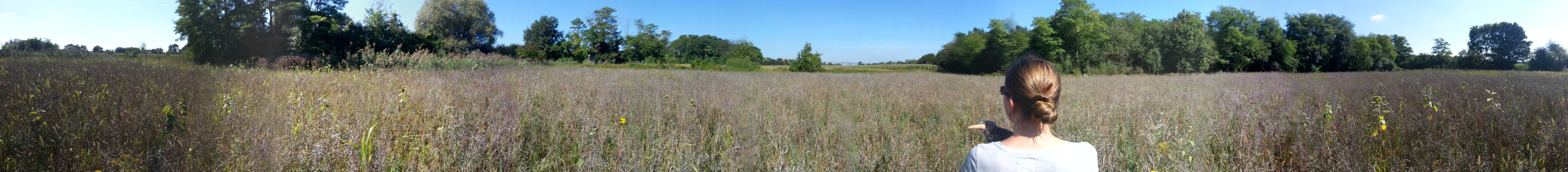
At this time of the year there are many "Straußen" in the region of Freiburg and the Kaiserstuhl: small temporary inns run by vintners where you can have new grape most and tarte flambée. This is what Eleanor and my sister were up to when I scooped in with the geohashing idea. The coordinates for the day were directly next to the nuclear power plant of Fessenheim, close to the boarder on the French side of the river Rhine. Getting there was not too much of a problem, we could drive quite close to the coordinates on farm tracks through fields of corn, passing some "access denied, private property" signs. The last few hundred meters EleanorAbernathy and me walked while my sister and our niece waited at the car. The hashpoint turned out to be on a fallow field with knee high plants all around (see panorama picture). After taking the usual pictures, we returned to the car. The three others continued to their "Strauße" and for me the more exhausting part of the expedition began.
I have done this distance before, but today I underestimated two things: 1. the warm temperatures with the sun being stronger than expected and 2. me not being quite in shape. With too warm clothing and without anything to drink I got as far as about 18.5 km running and walked the remaining 3.5 km because my legs were killing me. It was fun nevertheless.
Tracklog
Photos
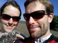
Obligatory stupid grin.
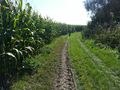
Some corn fields near the coordinates.
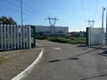
The nuclear power plant at Fessenheim.
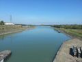
The river Rhine.
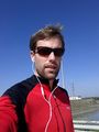
Attempt to take my picture while running.
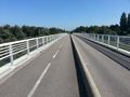
The Alain-Foechterle-Erich-Dilger-Bridge.
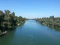
River Rhine again.
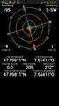
Obligatory proof.


Achievements
EleanorAbernathy and LeslieHapablap earned the Land geohash achievement
|
EleanorAbernathy, LeslieHapablap earned the Border geohash achievement
|