Difference between revisions of "2013-09-27 49 8"
imported>LeslieHapablap |
m (escape old link with <nowiki>) |
||
| (17 intermediate revisions by 5 users not shown) | |||
| Line 1: | Line 1: | ||
| − | |||
<!-- If you did not specify these parameters in the template, please substitute appropriate values for IMAGE, LAT, LON, and DATE (YYYY-MM-DD format) | <!-- If you did not specify these parameters in the template, please substitute appropriate values for IMAGE, LAT, LON, and DATE (YYYY-MM-DD format) | ||
| Line 13: | Line 12: | ||
| lon=8 | | lon=8 | ||
| date=2013-09-27 | | date=2013-09-27 | ||
| − | }} | + | }} __NOTOC__ |
| − | |||
| − | |||
| − | __NOTOC__ | ||
== Location == | == Location == | ||
| − | + | Three days after creating my account at XKCD I have the chance to visit my first geohash near Fehlheim.<br>The location is easy to reach (near [https://de.wikipedia.org/wiki/Fehlheim Fehlheim] in the graticule [[Mannheim, Germany|Mannheim (49, 8)]]), but sturdy shoes are advisable as it goes over a harrowed field. | |
| − | |||
| − | + | The car can be parked next to the soccer field. Here begins some event today, and it is expected that sports court and side roads will be very busy later in the day. | |
| − | + | Optical target: The big poplar by the brook. | |
| − | + | On the way to the little stream, it is found incidentally that the area goes down here about 1 m to 1.5 m: Here is the old Neckar bed. There is also a geocache (Earthcache [http://www.geocaching.com/geocache/GC4FEZY GC4FEZY]) on this subject. Guess whose EC it is. ;-) | |
== Participants == | == Participants == | ||
| − | |||
* [[User:Q-Owl|Q-Owl]] | * [[User:Q-Owl|Q-Owl]] | ||
| − | |||
| − | |||
| − | |||
== Expedition == | == Expedition == | ||
<!-- how it all turned out. your narrative goes here. --> | <!-- how it all turned out. your narrative goes here. --> | ||
| + | Today I was here alone at about 14:45 h in beautiful weather. Member at <nowiki>http://wiki.xkcd.com</nowiki> the third day and already a location near us that could be done within 20 minutes. :-) | ||
| − | + | Since I'm new here, my contribution may be improved by insiders. | |
| − | |||
| − | |||
| − | |||
| − | |||
| − | |||
== Photos == | == Photos == | ||
| − | + | Here some Photos of this trip after I found out how to upload them. (very difficult here) | |
| − | <!-- | + | <!-- |
| − | + | Liste hochgeladener Dateien: | |
| + | http://wiki.xkcd.com/wgh/index.php?title=Special%3AListFiles&limit=50&ilsearch=&user=Q-Owl | ||
| + | <gallery perrow="5" > | ||
--> | --> | ||
| − | <gallery | + | <gallery> |
| + | Image:2013-09-27 start.jpeg | The old Neckarbed, view to NW. The HP is near the tall Poplar. | ||
| + | Image:Screenshot 2013-09-27-14-47-43.png | Hashpoint reached (Screenshot Smartphone) | ||
| + | </gallery> | ||
| + | <gallery> | ||
| + | Image:20130927 144919.jpg | At the Hashpoint; view to north. | ||
| + | Image:2013-09-27 view east.jpeg | View to east (some houses of Fehlheim and behind that mountain "Melibokus"). | ||
| + | Image:20130927 144856.jpg | View to south (in the background left the sports ground). | ||
| + | Image:20130927 144913.jpg | View to west | ||
</gallery> | </gallery> | ||
| Line 55: | Line 52: | ||
{{#vardefine:ribbonwidth|800px}} | {{#vardefine:ribbonwidth|800px}} | ||
<!-- Add any achievement ribbons you earned below, or remove this section --> | <!-- Add any achievement ribbons you earned below, or remove this section --> | ||
| + | {{land geohash | ||
| + | |||
| + | | latitude = 49 | ||
| + | | longitude = 8 | ||
| + | | date = 2013-09-27 | ||
| + | | name = [[User:Q-Owl|Q-Owl]] | ||
| + | }} | ||
<!-- =============== USEFUL CATEGORIES FOLLOW ================ | <!-- =============== USEFUL CATEGORIES FOLLOW ================ | ||
| Line 61: | Line 65: | ||
<!-- Potential categories. Please include all the ones appropriate to your expedition --> | <!-- Potential categories. Please include all the ones appropriate to your expedition --> | ||
| − | |||
| − | |||
| − | |||
[[Category:Expeditions]] | [[Category:Expeditions]] | ||
| Line 76: | Line 77: | ||
--> | --> | ||
| − | <!-- if you reached your coords: | + | <!-- if you reached your coords: --> |
[[Category:Coordinates reached]] | [[Category:Coordinates reached]] | ||
| − | + | {{location|DE|HE|HP}} | |
| − | |||
| − | |||
| − | |||
| − | |||
| − | |||
| − | |||
| − | |||
| − | |||
| − | |||
| − | |||
| − | |||
| − | |||
| − | |||
| − | |||
| − | |||
| − | |||
| − | |||
Latest revision as of 16:02, 13 February 2020
| Fri 27 Sep 2013 in 49,8: 49.7064000, 8.5644503 geohashing.info google osm bing/os kml crox |
Location
Three days after creating my account at XKCD I have the chance to visit my first geohash near Fehlheim.
The location is easy to reach (near Fehlheim in the graticule Mannheim (49, 8)), but sturdy shoes are advisable as it goes over a harrowed field.
The car can be parked next to the soccer field. Here begins some event today, and it is expected that sports court and side roads will be very busy later in the day.
Optical target: The big poplar by the brook.
On the way to the little stream, it is found incidentally that the area goes down here about 1 m to 1.5 m: Here is the old Neckar bed. There is also a geocache (Earthcache GC4FEZY) on this subject. Guess whose EC it is. ;-)
Participants
Expedition
Today I was here alone at about 14:45 h in beautiful weather. Member at http://wiki.xkcd.com the third day and already a location near us that could be done within 20 minutes. :-)
Since I'm new here, my contribution may be improved by insiders.
Photos
Here some Photos of this trip after I found out how to upload them. (very difficult here)
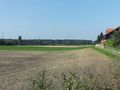
The old Neckarbed, view to NW. The HP is near the tall Poplar.
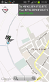
Hashpoint reached (Screenshot Smartphone)


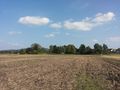
At the Hashpoint; view to north.
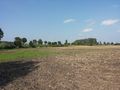
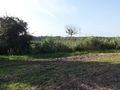
View to east (some houses of Fehlheim and behind that mountain "Melibokus").
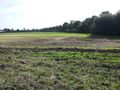
View to south (in the background left the sports ground).
View to west


Achievements
Q-Owl earned the Land geohash achievement
|