Difference between revisions of "2013-09-28 40 -74"
From Geohashing
imported>Jevanyn ([live] Well, we're parked in front of 2237 April Dr. The geohash is about 20 feet up into their front yard.) |
imported>FippeBot m (Location) |
||
| (6 intermediate revisions by one other user not shown) | |||
| Line 18: | Line 18: | ||
__NOTOC__ | __NOTOC__ | ||
== Location == | == Location == | ||
| − | + | April Dr., Bridgewater. | |
== Participants == | == Participants == | ||
| − | + | [[User:Jevanyn|Jevanyn]] ([[User talk:Jevanyn|talk]]): I think the four of us were there, but I don't recall completely, only have pictures of myself. | |
| − | |||
== Plans == | == Plans == | ||
| − | + | Only a few miles from home, so we made the expedition as part of a driving excursion to pass the time that day. | |
== Expedition == | == Expedition == | ||
| − | |||
*Well, we're parked in front of 2237 April Dr. The geohash is about 20 feet up into their front yard. -- [[User:Jevanyn|Jevanyn]] ([[User talk:Jevanyn|talk]]) [http://www.openstreetmap.org/?lat=40.59734632&lon=-74.53603873&zoom=16&layers=B000FTF @40.5973,-74.5360] 15:51, 28 September 2013 (EDT) | *Well, we're parked in front of 2237 April Dr. The geohash is about 20 feet up into their front yard. -- [[User:Jevanyn|Jevanyn]] ([[User talk:Jevanyn|talk]]) [http://www.openstreetmap.org/?lat=40.59734632&lon=-74.53603873&zoom=16&layers=B000FTF @40.5973,-74.5360] 15:51, 28 September 2013 (EDT) | ||
| − | |||
| − | |||
== Photos == | == Photos == | ||
| − | |||
| − | |||
| − | |||
<gallery perrow="5"> | <gallery perrow="5"> | ||
| − | |||
| − | == | + | Image:2013-09-28_40_-74_15-54-30-565.jpg | "This is as close as the GPS accuracy gets, yay!" [http://www.openstreetmap.org/?lat=40.59734423&lon=-74.53584719&zoom=16&layers=B000FTF @40.5973,-74.5358] |
| − | |||
| − | |||
| + | Image:2013-09-28_40_-74_15-55-19-152.jpg | Is this my good side? [http://www.openstreetmap.org/?lat=40.59731737&lon=-74.53598873&zoom=16&layers=B000FTF @40.5973,-74.5360] | ||
| − | + | Image:2013-09-28_40_-74_15-56-33-956.jpg | The Geohash at the End of the Sidewalk, by Shel Silversteen [http://www.openstreetmap.org/?lat=40.59732746&lon=-74.53599624&zoom=16&layers=B000FTF @40.5973,-74.5360] | |
| − | |||
| − | |||
| − | + | Image:2013-09-28_40_-74_15-58-11-503.jpg | Not exactly the Batmobile [http://www.openstreetmap.org/?lat=40.59734056&lon=-74.53599144&zoom=16&layers=B000FTF @40.5973,-74.5360] | |
| − | + | </gallery> | |
| − | [ | ||
| − | |||
| − | + | == Achievements == | |
| + | {{#vardefine:ribbonwidth|800px}} | ||
[[Category:Expeditions]] | [[Category:Expeditions]] | ||
| − | |||
[[Category:Expeditions with photos]] | [[Category:Expeditions with photos]] | ||
| − | |||
| − | |||
| − | |||
| − | |||
| − | |||
[[Category:Coordinates reached]] | [[Category:Coordinates reached]] | ||
| − | + | {{location|US|NJ|SO}} | |
| − | |||
| − | |||
| − | |||
| − | |||
| − | |||
| − | |||
| − | |||
| − | |||
| − | |||
| − | |||
| − | |||
| − | |||
| − | |||
| − | |||
| − | |||
| − | |||
| − | |||
Latest revision as of 04:09, 14 August 2019
| Sat 28 Sep 2013 in 40,-74: 40.5975143, -74.5359618 geohashing.info google osm bing/os kml crox |
Location
April Dr., Bridgewater.
Participants
Jevanyn (talk): I think the four of us were there, but I don't recall completely, only have pictures of myself.
Plans
Only a few miles from home, so we made the expedition as part of a driving excursion to pass the time that day.
Expedition
- Well, we're parked in front of 2237 April Dr. The geohash is about 20 feet up into their front yard. -- Jevanyn (talk) @40.5973,-74.5360 15:51, 28 September 2013 (EDT)
Photos
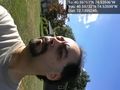
"This is as close as the GPS accuracy gets, yay!" @40.5973,-74.5358
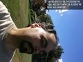
Is this my good side? @40.5973,-74.5360
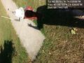
The Geohash at the End of the Sidewalk, by Shel Silversteen @40.5973,-74.5360
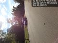
Not exactly the Batmobile @40.5973,-74.5360


