Difference between revisions of "2013-10-09 51 5"
imported>Eupeodes (→Photos) |
imported>FippeBot m (Location) |
||
| (3 intermediate revisions by one other user not shown) | |||
| Line 51: | Line 51: | ||
== Achievements == | == Achievements == | ||
| + | Besides stuff like land and bike there is a new one in it. | ||
{{#vardefine:ribbonwidth|800px}} | {{#vardefine:ribbonwidth|800px}} | ||
| − | + | {{Hash collision | |
| + | | latitude = 51 | ||
| + | | longitude = 5 | ||
| + | | date = 2013-10-09 | ||
| + | | name = [[User:Eupeodes|Eupeodes]] | ||
| + | | id = GC4FR3F | ||
| + | | distance = 270 meters in line of sight | ||
| + | | image = 2013-10-09_51_5_log.jpg | ||
| + | }} | ||
| − | |||
| − | |||
| − | |||
| − | |||
| − | |||
| − | |||
| − | |||
| − | |||
| − | |||
| − | |||
| − | |||
[[Category:Expeditions]] | [[Category:Expeditions]] | ||
| − | |||
[[Category:Expeditions with photos]] | [[Category:Expeditions with photos]] | ||
| − | |||
| − | |||
| − | |||
| − | |||
| − | |||
[[Category:Coordinates reached]] | [[Category:Coordinates reached]] | ||
| − | + | [[Category:Eupeodes]] | |
| − | + | {{location|NL|GE}} | |
| − | |||
| − | [[Category: | ||
| − | |||
| − | |||
| − | |||
| − | |||
| − | |||
| − | |||
| − | |||
| − | |||
| − | |||
| − | |||
| − | |||
| − | |||
| − | |||
| − | |||
Latest revision as of 04:15, 14 August 2019
| Wed 9 Oct 2013 in 51,5: 51.8699610, 5.3834400 geohashing.info google osm bing/os kml crox |
Location
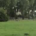
In a field just west of Tiel
Participants
Plans
Cycle there, visit the point, look for a nearby geocache (GC4FR3F) which might be in line of sight.
Expedition
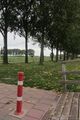
Left home after lunch with my recumbent bike. Found the point very easily, the only question was how to enter the field. The fence wasn't closed well, so climbing over it was not a good option, but it could be opened. I walked into the field and soon reached the point. After some pictures I walked back and cycled to the cache. Soon I noticed that this might be line of sight, but first I had to find it. In the end I found it, but forgot to take pictures, so I had to find it again (which was easy of course). And it was in line of sight from the hash! After this I cycled back home.
Photos
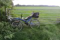
My bike
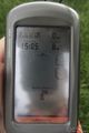
Proof
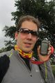
Grin
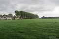
The view
At the edge of the small bridge is the cache
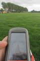
Compass trying to indicate the direction of the cache
View towards the hashpoint from the cachepoint
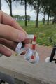
The log of the geocache


Achievements
Besides stuff like land and bike there is a new one in it.
Eupeodes earned the Hash collision achievement
|