Difference between revisions of "2013-10-11 47 18"
imported>LeslieHapablap (Created page with "{{subst:Expedition |lat = 47 |lon = 18 |date = 2013-10-11 }}") |
m (per Renaming Proposal) |
||
| (31 intermediate revisions by 3 users not shown) | |||
| Line 9: | Line 9: | ||
And DON'T FORGET to add your expedition and the best photo you took to the gallery on the Main Page! We'd love to read your report, but that means we first have to discover it! :) | And DON'T FORGET to add your expedition and the best photo you took to the gallery on the Main Page! We'd love to read your report, but that means we first have to discover it! :) | ||
--> | --> | ||
| + | [[Image:20131011 094014.jpg|left|900px]] | ||
{{meetup graticule | {{meetup graticule | ||
| lat=47 | | lat=47 | ||
| Line 14: | Line 15: | ||
| date=2013-10-11 | | date=2013-10-11 | ||
}} | }} | ||
| − | + | {{ClearLeft}} | |
<!-- edit as necessary --> | <!-- edit as necessary --> | ||
__NOTOC__ | __NOTOC__ | ||
== Location == | == Location == | ||
<!-- where you've surveyed the hash to be --> | <!-- where you've surveyed the hash to be --> | ||
| + | On a field near Tárnok, just outside of the city borders of Budapest. | ||
== Participants == | == Participants == | ||
<!-- who attended: If you link to your wiki user name in this section, your expedition will be picked up by the various statistics generated for geohashing. You may use three tildes ~ as a shortcut to automatically insert the user signature of the account you are editing with. | <!-- who attended: If you link to your wiki user name in this section, your expedition will be picked up by the various statistics generated for geohashing. You may use three tildes ~ as a shortcut to automatically insert the user signature of the account you are editing with. | ||
--> | --> | ||
| + | * [[User:LeslieHapablap|LeslieHapablap]] ([[2013-09-29 47 10|previous]]|[[2013-10-24 47 11|next]]) | ||
| + | * [[User:LeslieHapablap/Waltraud|Waltraud]] the hashkiwi | ||
== Plans == | == Plans == | ||
<!-- what were the original plans --> | <!-- what were the original plans --> | ||
| + | Currently I'm visiting a group we are collaborating with at the Wigner Research Centre for Physics in Budapest. All week long I was watching the hashpoints, and finally on the last day of may stay a good one pops up. Seems accessible on a field, very well connected to Budapest by train, virgin graticule, I'm free for the morning, so there is really no good reason not to try. The plan is to go from Budapest-Déli to Tárnok by train, then walk about 1 km to the coordinates. As I already got the e-tickets for the train (930 HUF for the return trip, that is 3.15 € or 4.26 USD) it is pretty sure I will make the attempt and go for it. I plan to arrive between 9.45 and 10.00 am. | ||
== Expedition == | == Expedition == | ||
<!-- how it all turned out. your narrative goes here. --> | <!-- how it all turned out. your narrative goes here. --> | ||
| + | [[File:2013-10-11 47 18 12-31-14-364.jpg|150px|thumb|left|Matthias Chruch.]] | ||
| + | My accommodation during my visit to Budapest is a very nice place: the Guesthouse of the Hungarian Academy of Science, located in the Buda Castle up on a hill. This is where many tourists come for sightseeing of the castle and the Matthias Church. But also it is conveniently close to the train station Budapest-Déli, which comes in handy if you want to go on a spontaneous geohash adventure in the suburbs of Budapest. | ||
| + | |||
| + | Budapest is divided by the 19th longitude, and I was hoping for reachable coordinates in the graticule [[47,18]] all week long as it has never been visited before. Finally on Thursday afternoon at hash-o-clock, zbot was feeling gracious and presented me coordinates in this graticule approximately 20 km (12 miles) away (yes, I know people believe the Dow Jones determines the coordinates, but I'm pretty sure it is zbot manipulating the stock market together with his trading-computer friends from Wall Street). Upon further inspection and investigation of my options to go there, the hashpoint turned out to be almost perfect: accessible just a few meters into a field next to a public road and close to the train station of Tárnok with direct and frequent connections to Budapest-Déli. Also I knew I had some spare time on Friday morning, so this was just too good not to go. | ||
| + | |||
| + | [[File:2013-10-11 47 18 12-38-27-983.jpg|300px|thumb|right|Waltraud at the hashpoint.]] | ||
| + | I could already buy my train tickets on-line, where I received a number to claim it later at the station. This on-line purchase process worked like a charm, not like ÖBB (the Austrian railway company) where the system crashes or is down almost always when I try to book a ticket. | ||
| − | + | Friday morning after breakfast I took along [[User:LeslieHapablap/Waltraud|Waltraud]] in my pocket and we walked to the station Budapest-Déli. After printing my ticket there I got onto the train to Tárnok, the train ride took about 30 min. Arriving there I had to walk a few hundred meters along quite busy roads without a sidewalk, but soon I saw my destination as I remembered it from Google Streetview. I had hoped the field would have been harvested by now, but there was still crops on it as tall as a man. Luckily the coordinates were only a few meters into the field and the crops was not too dense, so it was no problem to reach the hashpoint and take all the obligatory pictures there. [[User:LeslieHapablap/Waltraud|Waltraud]] and I were very pleased with our success. We returned to the train station were we had to wait for over half an hour unfortunately, but then the train took us home safely. {{-}} | |
| − | |||
== Photos == | == Photos == | ||
| Line 38: | Line 49: | ||
--> | --> | ||
<gallery perrow="5"> | <gallery perrow="5"> | ||
| + | |||
| + | Image:2013-10-11_47_18_12-28-19-755.jpg | Waltraud checking the weather and being excited about geohashing in Hungary. | ||
| + | |||
| + | Image:2013-10-11_47_18_12-29-16-144.jpg | The guesthouse, located in the Buda castle. | ||
| + | |||
| + | Image:2013-10-11_47_18_12-31-14-364.jpg | Passing Matthias Church. | ||
| + | |||
| + | Image:2013-10-11_47_18_12-33-51-900.jpg | On my way down to Budapest-Déli. | ||
| + | |||
| + | Image:2013-10-11_47_18_12-35-07-848.jpg | The train to Tárnok. | ||
| + | |||
| + | Image:2013-10-11_47_18_12-35-34-575.jpg | My tickets. | ||
| + | |||
| + | Image:2013-10-11_47_18_12-36-30-286.jpg | The field containing the hash point. | ||
| + | |||
| + | Image:2013-10-11_47_18_12-37-17-443.jpg | Obligatory proof. | ||
| + | |||
| + | Image:2013-10-11_47_18_12-38-27-983.jpg | Waltraud crops-surfing at the spot. | ||
| + | |||
| + | Image:2013-10-11_47_18_12-43-37-226.jpg | Obligatory stupid grin (clearly looking the four hours of sleep I had last night) | ||
| + | |||
| + | Image:2013-10-11_47_18_12-44-30-804.jpg | Back at the train station of Tárnok. | ||
| + | |||
| + | Image:2013-10-11_47_18_12-45-23-506.jpg | Climbing up to the castle, almost home again. | ||
</gallery> | </gallery> | ||
| Line 43: | Line 78: | ||
{{#vardefine:ribbonwidth|800px}} | {{#vardefine:ribbonwidth|800px}} | ||
<!-- Add any achievement ribbons you earned below, or remove this section --> | <!-- Add any achievement ribbons you earned below, or remove this section --> | ||
| + | {{land geohash | ||
| + | |||
| + | | latitude = 47 | ||
| + | | longitude = 18 | ||
| + | | date = 2013-10-11 | ||
| + | | name = [[User:LeslieHapablap|LeslieHapablap]] | ||
| + | }} | ||
| + | {{Graticule unlocked | ||
| + | | latitude = 47 | ||
| + | | longitude = 18 | ||
| + | | date = 2013-10-11 | ||
| + | | name = [[User:LeslieHapablap|LeslieHapablap]] | ||
| + | <!--| image = image name (optional) --> | ||
| + | |||
| + | }} | ||
| + | {{Public transport geohash | ||
| + | |||
| + | | latitude = 47 | ||
| + | | longitude = 18 | ||
| + | | date = 2013-10-11 | ||
| + | | busline = MÁV (Hungarian railway) | ||
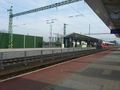
| + | | name = [[User:LeslieHapablap|LeslieHapablap]] | ||
| + | | image = 2013-10-11 47 18 12-35-34-575.jpg | ||
| + | |||
| + | }} | ||
<!-- =============== USEFUL CATEGORIES FOLLOW ================ | <!-- =============== USEFUL CATEGORIES FOLLOW ================ | ||
Delete the next line ONLY if you have chosen the appropriate categories below. If you are unsure, don't worry. People will read your report and help you with the classification. --> | Delete the next line ONLY if you have chosen the appropriate categories below. If you are unsure, don't worry. People will read your report and help you with the classification. --> | ||
| − | |||
<!-- Potential categories. Please include all the ones appropriate to your expedition --> | <!-- Potential categories. Please include all the ones appropriate to your expedition --> | ||
| Line 53: | Line 112: | ||
[[Category:Expedition planning]] | [[Category:Expedition planning]] | ||
--> | --> | ||
| − | + | [[Category:Expeditions]] | |
| + | [[Category:Expeditions with photos]] | ||
<!-- An actual expedition: | <!-- An actual expedition: | ||
[[Category:Expeditions]] | [[Category:Expeditions]] | ||
| Line 61: | Line 121: | ||
[[Category:Expedition without GPS]] | [[Category:Expedition without GPS]] | ||
--> | --> | ||
| − | + | [[Category:Coordinates reached]] | |
<!-- if you reached your coords: | <!-- if you reached your coords: | ||
[[Category:Coordinates reached]] | [[Category:Coordinates reached]] | ||
| Line 82: | Line 142: | ||
(Don't forget to delete this final close comment marker) --> | (Don't forget to delete this final close comment marker) --> | ||
| + | {{location|HU|ER}} | ||
Latest revision as of 05:19, 20 March 2024

| Fri 11 Oct 2013 in 47,18: 47.3631470, 18.8813477 geohashing.info google osm bing/os kml crox |
Location
On a field near Tárnok, just outside of the city borders of Budapest.
Participants
- LeslieHapablap (previous|next)
- Waltraud the hashkiwi
Plans
Currently I'm visiting a group we are collaborating with at the Wigner Research Centre for Physics in Budapest. All week long I was watching the hashpoints, and finally on the last day of may stay a good one pops up. Seems accessible on a field, very well connected to Budapest by train, virgin graticule, I'm free for the morning, so there is really no good reason not to try. The plan is to go from Budapest-Déli to Tárnok by train, then walk about 1 km to the coordinates. As I already got the e-tickets for the train (930 HUF for the return trip, that is 3.15 € or 4.26 USD) it is pretty sure I will make the attempt and go for it. I plan to arrive between 9.45 and 10.00 am.
Expedition

My accommodation during my visit to Budapest is a very nice place: the Guesthouse of the Hungarian Academy of Science, located in the Buda Castle up on a hill. This is where many tourists come for sightseeing of the castle and the Matthias Church. But also it is conveniently close to the train station Budapest-Déli, which comes in handy if you want to go on a spontaneous geohash adventure in the suburbs of Budapest.
Budapest is divided by the 19th longitude, and I was hoping for reachable coordinates in the graticule 47,18 all week long as it has never been visited before. Finally on Thursday afternoon at hash-o-clock, zbot was feeling gracious and presented me coordinates in this graticule approximately 20 km (12 miles) away (yes, I know people believe the Dow Jones determines the coordinates, but I'm pretty sure it is zbot manipulating the stock market together with his trading-computer friends from Wall Street). Upon further inspection and investigation of my options to go there, the hashpoint turned out to be almost perfect: accessible just a few meters into a field next to a public road and close to the train station of Tárnok with direct and frequent connections to Budapest-Déli. Also I knew I had some spare time on Friday morning, so this was just too good not to go.

I could already buy my train tickets on-line, where I received a number to claim it later at the station. This on-line purchase process worked like a charm, not like ÖBB (the Austrian railway company) where the system crashes or is down almost always when I try to book a ticket.
Friday morning after breakfast I took along Waltraud in my pocket and we walked to the station Budapest-Déli. After printing my ticket there I got onto the train to Tárnok, the train ride took about 30 min. Arriving there I had to walk a few hundred meters along quite busy roads without a sidewalk, but soon I saw my destination as I remembered it from Google Streetview. I had hoped the field would have been harvested by now, but there was still crops on it as tall as a man. Luckily the coordinates were only a few meters into the field and the crops was not too dense, so it was no problem to reach the hashpoint and take all the obligatory pictures there. Waltraud and I were very pleased with our success. We returned to the train station were we had to wait for over half an hour unfortunately, but then the train took us home safely.
Photos
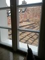
Waltraud checking the weather and being excited about geohashing in Hungary.
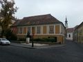
The guesthouse, located in the Buda castle.
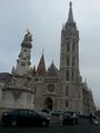
Passing Matthias Church.
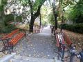
On my way down to Budapest-Déli.
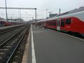
The train to Tárnok.
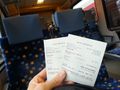
My tickets.
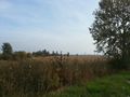
The field containing the hash point.
Obligatory proof.
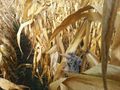
Waltraud crops-surfing at the spot.

Obligatory stupid grin (clearly looking the four hours of sleep I had last night)
Back at the train station of Tárnok.
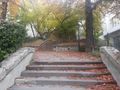
Climbing up to the castle, almost home again.


Achievements
LeslieHapablap earned the Land geohash achievement
|
LeslieHapablap earned the Graticule Unlocked Achievement
|
LeslieHapablap earned the Public transport geohash achievement
|