Difference between revisions of "2013-10-19 42 -85"
imported>Mcbaneg |
imported>FippeBot m (Location) |
||
| (3 intermediate revisions by one other user not shown) | |||
| Line 29: | Line 29: | ||
We were headed out to help a friend set up her house for a party, but she didn't seem to be in a panic, and the hashpoint was only about ten minutes south of town and very easily accessible about a mile off the highway. It also offered a two-way option: we could either figure out how to use the GPS in Susanne's fancy new phone, or we could go for the no-batteries because the location was so well-defined it would be easy to find without any electronic help at all. We went for the latter. | We were headed out to help a friend set up her house for a party, but she didn't seem to be in a panic, and the hashpoint was only about ten minutes south of town and very easily accessible about a mile off the highway. It also offered a two-way option: we could either figure out how to use the GPS in Susanne's fancy new phone, or we could go for the no-batteries because the location was so well-defined it would be easy to find without any electronic help at all. We went for the latter. | ||
| − | The hashpoint was at the west edge of a sidewalk, about ten feet north of a particular road intersection. We were there about 5 pm, but saw no evidence of other geohashers. Off to the party... | + | The hashpoint was at the west edge of a sidewalk, about ten feet north of a particular road intersection. We were there about 5 pm, but saw no evidence of other (nonstationary) geohashers. Off to the party... |
| − | |||
| − | |||
== Photos == | == Photos == | ||
| Line 38: | Line 36: | ||
--> | --> | ||
<gallery perrow="4"> | <gallery perrow="4"> | ||
| − | Image:2013-10-19 2 -85 George-hydrant.jpg|George at the hashpoint, looking north. The fire hydrant | + | Image:2013-10-19 2 -85 George-hydrant.jpg|George at the hashpoint, with the camera (and Susanne) looking north. The fire hydrant and tree show up in the satmap. |
Image:2013-10-19 42 -85 scarecrow.jpg|The only other geohasher we encountered. We think she hadn't checked the coordinates carefully since she was about 50 feet out of position. | Image:2013-10-19 42 -85 scarecrow.jpg|The only other geohasher we encountered. We think she hadn't checked the coordinates carefully since she was about 50 feet out of position. | ||
</gallery> | </gallery> | ||
| Line 68: | Line 66: | ||
[[Category:Expeditions with photos]] | [[Category:Expeditions with photos]] | ||
[[Category:Coordinates reached]] | [[Category:Coordinates reached]] | ||
| + | {{location|US|MI|KN}} | ||
Latest revision as of 04:21, 14 August 2019

| Sat 19 Oct 2013 in 42,-85: 42.8302104, -85.6963933 geohashing.info google osm bing/os kml crox |
Location
sidewalk in a suburban neighborhood south of Grand Rapids, MI, USA
Participants
Expedition
We were headed out to help a friend set up her house for a party, but she didn't seem to be in a panic, and the hashpoint was only about ten minutes south of town and very easily accessible about a mile off the highway. It also offered a two-way option: we could either figure out how to use the GPS in Susanne's fancy new phone, or we could go for the no-batteries because the location was so well-defined it would be easy to find without any electronic help at all. We went for the latter.
The hashpoint was at the west edge of a sidewalk, about ten feet north of a particular road intersection. We were there about 5 pm, but saw no evidence of other (nonstationary) geohashers. Off to the party...
Photos

George at the hashpoint, with the camera (and Susanne) looking north. The fire hydrant and tree show up in the satmap.
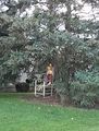
The only other geohasher we encountered. We think she hadn't checked the coordinates carefully since she was about 50 feet out of position.


Achievements
George and Susanne earned the Land geohash achievement
|
George and Susanne earned the No Batteries Geohash Achievement
|