Difference between revisions of "2013-10-19 49 8"
imported>GeorgDerReisende (new expedition to Nieder-Ramstadt) |
imported>FippeBot m (Location) |
||
| (7 intermediate revisions by 2 users not shown) | |||
| Line 9: | Line 9: | ||
== Location == | == Location == | ||
| − | The hash lies at the southern edge of a former quarry in the village Nieder-Ramstadt, county Darmstadt-Dieburg. | + | The hash lies directly at the fence at the southern edge of a former quarry in the village Nieder-Ramstadt, county Darmstadt-Dieburg. |
== Participants == | == Participants == | ||
| − | [[User:GeorgDerReisende|GeorgDerReisende]] | + | *[[User:GeorgDerReisende|GeorgDerReisende]] |
| + | *[[User:Danatar|Danatar]] | ||
== Plans == | == Plans == | ||
| − | [[User:GeorgDerReisende|GeorgDerReisende]] wants to try hitchhiking to this place from Kassel, but this time starting at Wilhelmshöhe. | + | [[User:GeorgDerReisende|GeorgDerReisende]] wants to try hitchhiking to this place from Kassel, but this time starting at Wilhelmshöhe. He will be there at 16:00 for the xkcd-meetup. |
| + | |||
| + | [[User:Danatar|Danatar]] will make a detour on the way to his parents and also plans to be there at meetup time. | ||
== Expedition == | == Expedition == | ||
| − | |||
| − | == | + | ===[[User:GeorgDerReisende|GeorgDerReisende]]=== |
| − | + | ||
| + | Sorry, I failed again. I started at home at 10am, and went to the Wilhelmshöhe junction of the A44 and waited there for two hours, but nobody stopped. Then I wanted to try it at the Auestadion. On the way to there, I have seen a lot of cranes. At Auestadion I waited for another hour, but again nobody stopped. Then I gave up and went home. | ||
| − | |||
| − | |||
| − | |||
| − | |||
<gallery perrow="5"> | <gallery perrow="5"> | ||
| + | Image:2013-10-19 49 8 GeorgDerReisende 1859.jpg | junction Wilhelmhöhe at the A44 | ||
| + | Image:2013-10-19 49 8 GeorgDerReisende 1864.jpg | two hours later: grrrr | ||
| + | Image:2013-10-19 49 8 GeorgDerReisende 1871.jpg | cranes | ||
| + | Image:2013-10-19 49 8 GeorgDerReisende 1873.jpg | cranes | ||
</gallery> | </gallery> | ||
| − | + | The result is: since the closing of the service station Kassel southbound there is no possibility at all to hitchhike to the south from Kassel. Maybe via Marburg. Everybody and I has to go from the Dresdener Straße north to the service station Göttingen and has to change there the direction, this detour will need two hours of travel time. | |
| − | + | ||
| − | + | ||
| + | ===[[User:Danatar|Danatar]]=== | ||
| − | + | I had planned to visit my parents and the hashpoint was more or less on the way. Lunch with a friend took a little longer than planned, so I started at 14:30 instead of 14:00. There was much traffic on the Autobahn, but luckily no traffic jams, just enough traffic that I couldn't go quite as fast as I wanted. After passing Aschaffenburg, I left the Autobahn and followed various federal roads. Those dragged on longer than I expected and 4 p.m. came nearer and nearer. After Groß-Zimmern I went along smaller streets and through towns, finally arriving at Nieder-Ramstadt at 16:10. Finding a convenient place to park the car and walking along a small track took another few minutes and I knew I was too late for meetup time. | |
| − | |||
| − | |||
| − | + | I reached the area near the hashpoint and discovered a fence, with a "No trespassing, mortal danger!" sign. I already knew that the lake from the satellite image was in an abandoned quarry, but I didn't expect it to be fenced, and certainly not that the hashpoint would be inside the fence. I had expected there to be the lake with a track around it and without anything blocking my way. I walked along the fence in both directions, but the fence remained there. Behind the fence I could see the almost vertical slope going down into the quarry, so I really couldn't blame anyone for building that fence. Just before giving up, I took a look at my GPS receiver. Until then, I had navigated by a satellite image printout and without really thinking about it I had taken that one line on the map for the fence, when in reality it indicated the track running along the fence. But on the GPS unit I saw that I was already further north than the hashpoint by 0.00001 degrees, while only a few metres east of it. And apparently the satellite map's accuracy was not top notch here. Instead of being 10 m inside the quarry, the hashpoint turned out to be at the corner where the fence turned from running northwest-southeast to west-east. With a little patience and walking left and right I finally caught a moment when the GPS unit showed the exact coordinates while still being on my side of the fence. So I had reached the spot after all, hooray! | |
| − | |||
| − | |||
| − | |||
| − | + | While taking pictures I heard loud squeaking from the other side of the fence, indicating wild boars. After holding still for a while and listening for the rustling of leaves, I saw a shadow walking past in the underbrush, but couldn't recognize anything. I carefully followed the squeaking along the fence, when suddenly I saw one wild boar squeeze itself through a hole in the fence and running across the track, disappearing in the bushes on my side of the fence. Unfortunately I wasn't fast enough to take a picture. I waited for a while, but nothing happened, so I walked back to my car and drove on. | |
| − | |||
| − | |||
| − | |||
| − | |||
| − | |||
| − | |||
| − | |||
| − | |||
| − | |||
| − | -- | + | <gallery> |
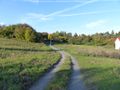
| − | + | File:2013-10-19_49_8_weg.jpg | |
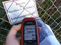
| − | -- | + | File:2013-10-19_49_8_gps.jpg|GPS |
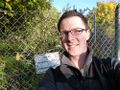
| − | + | File:2013-10-19_49_8_hp.jpg|coordinates reached, without trespassing | |
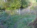
| − | + | File:2013-10-19_49_8_spot.jpg|hashpoint | |
| − | + | File:2013-10-19_49_8_pano.jpg|panorama | |
| − | + | File:2013-10-19_49_8_zaun.jpg|fence going around the quarry | |
| − | + | File:2013-10-19_49_8_steinbruch.jpg|an old building and the lake in the quarry | |
| + | File:2013-10-19_49_8_katze.jpg|a cat was waiting at my car | ||
| + | </gallery> | ||
| − | + | === Tracklog === | |
| − | + | I forgot to save the track, so it was overwritten :-( | |
| − | |||
| − | |||
| − | |||
| − | + | [[Category:Expeditions]] | |
| + | [[Category:Expeditions with photos]] | ||
| + | [[Category:Coordinates reached]] | ||
| + | [[Category:Danatar]] | ||
| + | {{location|DE|HE|DA}} | ||
Latest revision as of 04:22, 14 August 2019
| Sat 19 Oct 2013 in 49,8: 49.8302104, 8.6963933 geohashing.info google osm bing/os kml crox |
Location
The hash lies directly at the fence at the southern edge of a former quarry in the village Nieder-Ramstadt, county Darmstadt-Dieburg.
Participants
Plans
GeorgDerReisende wants to try hitchhiking to this place from Kassel, but this time starting at Wilhelmshöhe. He will be there at 16:00 for the xkcd-meetup.
Danatar will make a detour on the way to his parents and also plans to be there at meetup time.
Expedition
GeorgDerReisende
Sorry, I failed again. I started at home at 10am, and went to the Wilhelmshöhe junction of the A44 and waited there for two hours, but nobody stopped. Then I wanted to try it at the Auestadion. On the way to there, I have seen a lot of cranes. At Auestadion I waited for another hour, but again nobody stopped. Then I gave up and went home.
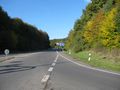
junction Wilhelmhöhe at the A44
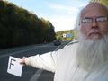
two hours later: grrrr
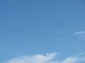
cranes
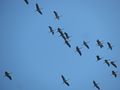
cranes


The result is: since the closing of the service station Kassel southbound there is no possibility at all to hitchhike to the south from Kassel. Maybe via Marburg. Everybody and I has to go from the Dresdener Straße north to the service station Göttingen and has to change there the direction, this detour will need two hours of travel time.
Danatar
I had planned to visit my parents and the hashpoint was more or less on the way. Lunch with a friend took a little longer than planned, so I started at 14:30 instead of 14:00. There was much traffic on the Autobahn, but luckily no traffic jams, just enough traffic that I couldn't go quite as fast as I wanted. After passing Aschaffenburg, I left the Autobahn and followed various federal roads. Those dragged on longer than I expected and 4 p.m. came nearer and nearer. After Groß-Zimmern I went along smaller streets and through towns, finally arriving at Nieder-Ramstadt at 16:10. Finding a convenient place to park the car and walking along a small track took another few minutes and I knew I was too late for meetup time.
I reached the area near the hashpoint and discovered a fence, with a "No trespassing, mortal danger!" sign. I already knew that the lake from the satellite image was in an abandoned quarry, but I didn't expect it to be fenced, and certainly not that the hashpoint would be inside the fence. I had expected there to be the lake with a track around it and without anything blocking my way. I walked along the fence in both directions, but the fence remained there. Behind the fence I could see the almost vertical slope going down into the quarry, so I really couldn't blame anyone for building that fence. Just before giving up, I took a look at my GPS receiver. Until then, I had navigated by a satellite image printout and without really thinking about it I had taken that one line on the map for the fence, when in reality it indicated the track running along the fence. But on the GPS unit I saw that I was already further north than the hashpoint by 0.00001 degrees, while only a few metres east of it. And apparently the satellite map's accuracy was not top notch here. Instead of being 10 m inside the quarry, the hashpoint turned out to be at the corner where the fence turned from running northwest-southeast to west-east. With a little patience and walking left and right I finally caught a moment when the GPS unit showed the exact coordinates while still being on my side of the fence. So I had reached the spot after all, hooray!
While taking pictures I heard loud squeaking from the other side of the fence, indicating wild boars. After holding still for a while and listening for the rustling of leaves, I saw a shadow walking past in the underbrush, but couldn't recognize anything. I carefully followed the squeaking along the fence, when suddenly I saw one wild boar squeeze itself through a hole in the fence and running across the track, disappearing in the bushes on my side of the fence. Unfortunately I wasn't fast enough to take a picture. I waited for a while, but nothing happened, so I walked back to my car and drove on.
GPS
coordinates reached, without trespassing
hashpoint
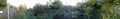
panorama
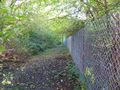
fence going around the quarry
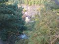
an old building and the lake in the quarry
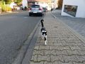
a cat was waiting at my car


Tracklog
I forgot to save the track, so it was overwritten :-(