Difference between revisions of "2013-10-20 44 -123"
imported>Frogman (→Participants) |
imported>FippeBot m (Location) |
||
| (9 intermediate revisions by 3 users not shown) | |||
| Line 15: | Line 15: | ||
}} | }} | ||
| − | |||
__NOTOC__ | __NOTOC__ | ||
== Location == | == Location == | ||
| − | Off of the John H. | + | Off of the John H. Beuter Road in Peavy Arboretum. |
== Participants == | == Participants == | ||
| − | + | ||
| − | + | * [[User:Frogman|Frogman]] | |
| − | [[User:Frogman|Frogman]] | + | * [[User:Higgs|Higgs]] did not reach the hashpoint |
== Plans == | == Plans == | ||
| − | + | ||
| + | I saw that this hash was pretty close to Corvallis, so I planned on doing it! | ||
== Expedition == | == Expedition == | ||
| − | + | ||
| + | I was surprised at the relatively easy ride up 99W, despite a couple of hills. Peavy Arboretum is an OSU-run demonstration forest on a hill surrounded by farms and streets that are named after being able to see Mt. Hood. It's a nice place! It was pretty busy, so I felt weird about tromping through the forest in an attempt to reach the hashpoint. I felt even more weird about the fact that the hashpoint was right off of a path, and my wanderings through thickets and heavy vegetation were unnecessary. | ||
| + | |||
| + | == [[User:Higgs|Higgs]]' Sad Story of Failure == | ||
| + | So [[User:Frogman|Frogman]] had introduced me to geohashing just days before and I thought it sounded really cool. So when he asked if I wanted to hit a bike hash on Sunday I was all for it. After stopping for a break about 2 miles in I realized I was way out of shape and I didn't know how far we were going. After [[User:Frogman|Frogman]] mentioned how far away it was I realized I wasn't in the condition to keep up with him for 13+ more miles. And so goes the story of how I failed my first geohash. | ||
== Tracklog == | == Tracklog == | ||
| Line 39: | Line 43: | ||
--> | --> | ||
<gallery perrow="5"> | <gallery perrow="5"> | ||
| + | Image: 2013-10-20 44 -123 ontheway.jpg | On the way! | ||
| + | Image: 2013-10-20 44 -123 tractor.jpg | A tractor. | ||
| + | Image: 2013-10-20 44 -123 signs1.jpg | I'm at the arboretum! | ||
| + | Image: 2013-10-20 44 -123 signs2.jpg | The arboretum in in McDonald forest. | ||
| + | Image: 2013-10-20 44 -123 signs3.jpg | There's a lot of stuff here. | ||
| + | Image: 2013-10-20 44 -123 arboretum.jpg | It was a super nice day! | ||
| + | Image: 2013-10-20 44 -123 redwoodsign.jpg | A sign for a redwood. | ||
| + | Image: 2013-10-20 44 -123 redwood.jpg | A redwood for a sign. | ||
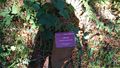
| + | Image: 2013-10-20 44 -123 information.jpg | Information! I should have looked at the trail map before starting. | ||
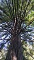
| + | Image: 2013-10-20 44 -123 treeeee.jpg | The trees are pretty here! | ||
| + | Image: 2013-10-20 44 -123 beuterroad.jpg | The road that would have taken me to the hashpoint if I had kept going. | ||
| + | Image: 2013-10-20 44 -123 path.jpg | Here it is again, after I had trekked through a lot of blackberry bushes. | ||
| + | Image: 2013-10-20 44 -123 hashpoint.jpg | This is the place! | ||
| + | Image: 2013-10-20 44 -123 view.jpg | From the hashpoint you could see a lot of thicket. | ||
| + | Image: 2013-10-20 44 -123 grin.jpg | Grin of the goofy variety. | ||
</gallery> | </gallery> | ||
| Line 45: | Line 64: | ||
<!-- Add any achievement ribbons you earned below, or remove this section --> | <!-- Add any achievement ribbons you earned below, or remove this section --> | ||
| + | {{bicycle geohash | ||
| + | | latitude = 44 | ||
| + | | longitude = -123 | ||
| + | | date = 2013-10-20 | ||
| + | | name = [[User:Frogman|Frogman]] ([[User talk:Frogman|talk]]) | ||
| + | | distance = 15.2 | ||
| + | | bothways = true | ||
| + | | image = 2013-10-20 44 -123 ontheway.jpg | ||
| + | }} | ||
| − | + | [[Category:Expeditions]] | |
| − | |||
| − | |||
| − | |||
| − | |||
| − | |||
| − | |||
| − | |||
| − | |||
| − | |||
| − | [[Category:Expeditions]] | ||
| − | |||
| − | |||
| − | |||
| − | |||
| − | |||
| − | |||
| − | |||
[[Category:Coordinates reached]] | [[Category:Coordinates reached]] | ||
| − | + | {{location|US|OR|BE}} | |
| − | |||
| − | |||
| − | |||
| − | |||
| − | |||
| − | |||
| − | |||
| − | |||
| − | |||
| − | |||
| − | |||
| − | |||
| − | |||
| − | |||
| − | |||
| − | |||
| − | |||
Latest revision as of 04:22, 14 August 2019
| Sun 20 Oct 2013 in 44,-123: 44.6560083, -123.2360833 geohashing.info google osm bing/os kml crox |
Location
Off of the John H. Beuter Road in Peavy Arboretum.
Participants
Plans
I saw that this hash was pretty close to Corvallis, so I planned on doing it!
Expedition
I was surprised at the relatively easy ride up 99W, despite a couple of hills. Peavy Arboretum is an OSU-run demonstration forest on a hill surrounded by farms and streets that are named after being able to see Mt. Hood. It's a nice place! It was pretty busy, so I felt weird about tromping through the forest in an attempt to reach the hashpoint. I felt even more weird about the fact that the hashpoint was right off of a path, and my wanderings through thickets and heavy vegetation were unnecessary.
Higgs' Sad Story of Failure
So Frogman had introduced me to geohashing just days before and I thought it sounded really cool. So when he asked if I wanted to hit a bike hash on Sunday I was all for it. After stopping for a break about 2 miles in I realized I was way out of shape and I didn't know how far we were going. After Frogman mentioned how far away it was I realized I wasn't in the condition to keep up with him for 13+ more miles. And so goes the story of how I failed my first geohash.
Tracklog
Photos
On the way!
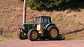
A tractor.
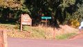
I'm at the arboretum!
The arboretum in in McDonald forest.
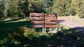
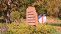
There's a lot of stuff here.
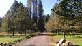
It was a super nice day!
A sign for a redwood.
A redwood for a sign.
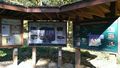
Information! I should have looked at the trail map before starting.
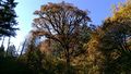
The trees are pretty here!
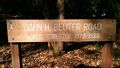
The road that would have taken me to the hashpoint if I had kept going.
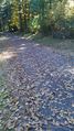
Here it is again, after I had trekked through a lot of blackberry bushes.
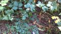
This is the place!
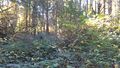
From the hashpoint you could see a lot of thicket.
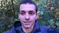
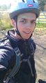
Grin of the goofy variety.


Achievements
Frogman (talk) earned the Bicycle geohash achievement
|