Difference between revisions of "2013-10-21 47 16"
imported>Patrizius ([live] Hurra! Wir sind da!) |
imported>FippeBot m (Location) |
||
| (8 intermediate revisions by 3 users not shown) | |||
| Line 18: | Line 18: | ||
__NOTOC__ | __NOTOC__ | ||
== Location == | == Location == | ||
| − | + | Hash location: Right beside a small road, between lake Neusiedlersee and another small lake. Very easy to pick up. | |
== Participants == | == Participants == | ||
| − | + | * [[User:Patrizius|Patrizius]] | |
| − | + | * [[User:B2c|B2c]] | |
== Plans == | == Plans == | ||
| − | + | This was one of our first expeditions, so really there was no plan. We just wanted to go there, try to find the spot and experiment with all the equipment (various gps receivers, cameras, phones, etc.). Also we wanted to check out, what the Geohash App for Android was capable of doing in order to get a feeling for what exactly we would be doing in the field and what would have to be done back home at the computer. | |
== Expedition == | == Expedition == | ||
<!-- how it all turned out. your narrative goes here. --> | <!-- how it all turned out. your narrative goes here. --> | ||
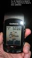
| + | This was a dry-run, so no expectations there. Yet we managed to find the hash quickly. Just had some problems on the follow-through. Didn't know how to make a nice screenshot on my Garmin Edge device, so I took a bad photo with my cellphone, which felt very clumsy. And on top of it all, we forgot to take a foto of ourselves (stupid grin). | ||
| + | But, we learned what works and what doesn't, what you need and what you don't need when you approach the hashpoint. | ||
| + | |||
| + | *Hurra! Wir sind da! -- [[User:Patrizius|Patrizius]] ([[User talk:Patrizius|talk]]) [http://www.openstreetmap.org/?lat=47.79431546&lon=16.78239546&zoom=16&layers=B000FTF @47.7943,16.7824] 14:44, 21 October 2013 (EDT) | ||
| + | *Schon wieder da -- [[User:B2c|B2c]] ([[User talk:B2c|talk]]) [http://www.openstreetmap.org/?lat=47.79433479&lon=16.78242880&zoom=16&layers=B000FTF @47.7943,16.7824] 20:55, 21 October 2013 (CEST) | ||
| − | |||
== Tracklog == | == Tracklog == | ||
<!-- if your GPS device keeps a log, you may post a link here --> | <!-- if your GPS device keeps a log, you may post a link here --> | ||
| Line 40: | Line 44: | ||
--> | --> | ||
<gallery perrow="5"> | <gallery perrow="5"> | ||
| + | |||
| + | Image:2013-10-21_47_16_20-46-49-962.jpg | Dry run. [http://www.openstreetmap.org/?lat=47.79431725&lon=16.78242480&zoom=16&layers=B000FTF @47.7943,16.7824] | ||
</gallery> | </gallery> | ||
| Line 46: | Line 52: | ||
<!-- Add any achievement ribbons you earned below, or remove this section --> | <!-- Add any achievement ribbons you earned below, or remove this section --> | ||
| − | |||
| − | |||
| − | |||
| − | |||
| − | |||
| − | |||
| − | |||
| − | |||
| − | |||
| − | |||
| − | |||
[[Category:Expeditions]] | [[Category:Expeditions]] | ||
| − | |||
[[Category:Expeditions with photos]] | [[Category:Expeditions with photos]] | ||
| − | |||
| − | |||
| − | |||
| − | |||
| − | |||
[[Category:Coordinates reached]] | [[Category:Coordinates reached]] | ||
| − | + | {{location|AT|B|ND}} | |
| − | |||
| − | |||
| − | |||
| − | |||
| − | |||
| − | |||
| − | |||
| − | |||
| − | |||
| − | |||
| − | |||
| − | |||
| − | |||
| − | |||
| − | |||
| − | |||
| − | |||
Latest revision as of 04:24, 14 August 2019
| Mon 21 Oct 2013 in 47,16: 47.7943517, 16.7824157 geohashing.info google osm bing/os kml crox |
Location
Hash location: Right beside a small road, between lake Neusiedlersee and another small lake. Very easy to pick up.
Participants
Plans
This was one of our first expeditions, so really there was no plan. We just wanted to go there, try to find the spot and experiment with all the equipment (various gps receivers, cameras, phones, etc.). Also we wanted to check out, what the Geohash App for Android was capable of doing in order to get a feeling for what exactly we would be doing in the field and what would have to be done back home at the computer.
Expedition
This was a dry-run, so no expectations there. Yet we managed to find the hash quickly. Just had some problems on the follow-through. Didn't know how to make a nice screenshot on my Garmin Edge device, so I took a bad photo with my cellphone, which felt very clumsy. And on top of it all, we forgot to take a foto of ourselves (stupid grin). But, we learned what works and what doesn't, what you need and what you don't need when you approach the hashpoint.
- Hurra! Wir sind da! -- Patrizius (talk) @47.7943,16.7824 14:44, 21 October 2013 (EDT)
- Schon wieder da -- B2c (talk) @47.7943,16.7824 20:55, 21 October 2013 (CEST)
Tracklog
Photos
Dry run. @47.7943,16.7824
