Difference between revisions of "2013-10-27 42 -91"
imported>Michael5000 m (→Participants) |
imported>FippeBot m (Location) |
||
| (15 intermediate revisions by 2 users not shown) | |||
| Line 1: | Line 1: | ||
| − | + | [[File:2013-10-27 42 -91 (9).JPG|thumb|left]] | |
| − | |||
| − | |||
| − | |||
| − | |||
| − | |||
| − | |||
{{meetup graticule | {{meetup graticule | ||
| lat=42 | | lat=42 | ||
| Line 23: | Line 17: | ||
== Participants == | == Participants == | ||
| − | [[User:Michael5000|Michael5000]] | + | [[User:Michael5000|Michael5000]] -- Expedition #150 |
== Plans == | == Plans == | ||
| − | + | ||
| + | After [[2013-10-26 43 -92]], I thought I'd stop by Guttenberg to confirm my suspicion that this one would be either in the river or on an inaccessible protected levee. What I discovered is that, along with a lovely riverside park, the town has twin trails at the top and bottom of the levee both. I got down on the lower trail, and voila! was able to stand at the hashpoint about eight hours before it became the hashpoint. Then, just to keep things surreal, a faux old-style Mississippi Riverboat came around the bend and through the nearby locks. | ||
| + | |||
| + | Since the hashpoint is for reals, I poked around town and found a motel. Then I went for a run on the levee trails, crossing the hashpoint again about six hours before it became the hashpoint. At this writing, it is still about three hours until it becomes the hashpoint. | ||
== Expedition == | == Expedition == | ||
| − | |||
| − | + | At a quarter to midnight, I drove back to the hashpoint. I forgot my flashlight, but I was able to get to the point at about 7 minutes to midnight by the silvery glow of my GPS. I sat down and took some pictures and enjoyed the smells and sounds of the great river at night. | |
| − | + | ||
| + | At two minutes to midnight, a voice from the upper trail said "Hello? Is somebody down there?" Heh. "Hello!" I said. There was a pause. "Are you fishing?" asked the clearly puzzled voice. And this made me think about how I taught a class a few days ago about how human communication inevitably contains not only information, but also an implicit attitude towards that information. And also about how much I didn't want to try to explain geohashing to an invisible stranger in a shouted midnight conversation during which I was pinned on the shore of a great river, 1500 miles from home. | ||
| + | |||
| + | So, I focused on conveying harmlessness, cheerful confidence, sanity, and goodwill while I called up "Nah! I'm just goofing off!" It seemed to work. | ||
| + | |||
| + | Then midnight arrived and the hashpoint came into being. I enjoyed the moment for a while longer, then headed back to the motel. | ||
== Photos == | == Photos == | ||
| − | + | ||
| − | |||
| − | |||
<gallery perrow="5"> | <gallery perrow="5"> | ||
| + | File:2013-10-27 42 -91 (4).JPG|The trail along the bottom of the levee... | ||
| + | File:2013-10-27 42 -91 (1).JPG|...that goes right over the hashpoint-to-be. | ||
| + | File:2013-10-27 42 -91 (3).JPG|Goofy grin fail. | ||
| + | File:2013-10-27 42 -91 (5).JPG|It is the Mississippi, so of course there's a riverboat. | ||
| + | File:2013-10-27 42 -91 (6).JPG|It goes into the locks. | ||
| + | File:2013-10-27 42 -91 (7).JPG|The actual expedition: Goofy grin win. | ||
| + | File:2013-10-27 42 -91 (8).JPG|The hashscot double-checks our position. | ||
| + | File:2013-10-27 42 -91 (9).JPG|Two... more... minutes... | ||
</gallery> | </gallery> | ||
| Line 44: | Line 51: | ||
{{#vardefine:ribbonwidth|800px}} | {{#vardefine:ribbonwidth|800px}} | ||
<!-- Add any achievement ribbons you earned below, or remove this section --> | <!-- Add any achievement ribbons you earned below, or remove this section --> | ||
| + | {{Midnight geohash | ||
| + | |||
| + | | latitude = 42 | ||
| + | | longitude = -91 | ||
| + | | date = 2013-10-27 | ||
| + | | name = [[user:Michael5000|Michael5000]] | ||
| + | |||
| + | }} | ||
| + | |||
| + | {{consecutive geohash 2 | ||
| + | | count = 3 | ||
| + | | latitude = 42 | ||
| + | | longitude = -90 | ||
| + | | date = 2013-10-25 | ||
| + | | name = [[user:Michael5000|Michael5000]] | ||
| − | + | }} | |
| − | |||
| − | |||
| − | |||
| − | |||
| − | |||
| − | |||
| − | |||
[[Category:Expeditions]] | [[Category:Expeditions]] | ||
| − | |||
[[Category:Expeditions with photos]] | [[Category:Expeditions with photos]] | ||
| − | |||
| − | |||
| − | |||
| − | |||
| − | |||
[[Category:Coordinates reached]] | [[Category:Coordinates reached]] | ||
| − | + | {{location|US|IA|CT}} | |
| − | |||
| − | |||
| − | |||
| − | |||
| − | |||
| − | |||
| − | |||
| − | |||
| − | |||
| − | |||
| − | |||
| − | |||
| − | |||
| − | |||
| − | |||
| − | |||
| − | |||
Latest revision as of 06:40, 6 August 2019
.JPG)
| Sun 27 Oct 2013 in 42,-91: 42.7883884, -91.0978016 geohashing.info google osm bing/os kml crox |
Location
On the shore of the Mississippi in Guttenberg, Iowa.
Participants
Michael5000 -- Expedition #150
Plans
After 2013-10-26 43 -92, I thought I'd stop by Guttenberg to confirm my suspicion that this one would be either in the river or on an inaccessible protected levee. What I discovered is that, along with a lovely riverside park, the town has twin trails at the top and bottom of the levee both. I got down on the lower trail, and voila! was able to stand at the hashpoint about eight hours before it became the hashpoint. Then, just to keep things surreal, a faux old-style Mississippi Riverboat came around the bend and through the nearby locks.
Since the hashpoint is for reals, I poked around town and found a motel. Then I went for a run on the levee trails, crossing the hashpoint again about six hours before it became the hashpoint. At this writing, it is still about three hours until it becomes the hashpoint.
Expedition
At a quarter to midnight, I drove back to the hashpoint. I forgot my flashlight, but I was able to get to the point at about 7 minutes to midnight by the silvery glow of my GPS. I sat down and took some pictures and enjoyed the smells and sounds of the great river at night.
At two minutes to midnight, a voice from the upper trail said "Hello? Is somebody down there?" Heh. "Hello!" I said. There was a pause. "Are you fishing?" asked the clearly puzzled voice. And this made me think about how I taught a class a few days ago about how human communication inevitably contains not only information, but also an implicit attitude towards that information. And also about how much I didn't want to try to explain geohashing to an invisible stranger in a shouted midnight conversation during which I was pinned on the shore of a great river, 1500 miles from home.
So, I focused on conveying harmlessness, cheerful confidence, sanity, and goodwill while I called up "Nah! I'm just goofing off!" It seemed to work.
Then midnight arrived and the hashpoint came into being. I enjoyed the moment for a while longer, then headed back to the motel.
Photos
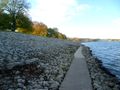
The trail along the bottom of the levee...
...that goes right over the hashpoint-to-be.

Goofy grin fail.

It is the Mississippi, so of course there's a riverboat.
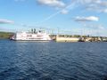
It goes into the locks.

The actual expedition: Goofy grin win.
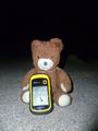
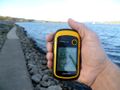
The hashscot double-checks our position.

Two... more... minutes...
.JPG)
.JPG)
.JPG)
.JPG)
.JPG)
.JPG)
.JPG)
Achievements
Michael5000 earned the Midnight Geohash achievement
|
Michael5000 earned the Consecutive geohash achievement
|