Difference between revisions of "2013-11-06 32 -82"
From Geohashing
imported>Tomkf61 (→Photos) |
imported>Tomkf61 (→Tracklog) |
||
| Line 33: | Line 33: | ||
== Expedition == | == Expedition == | ||
<!-- how it all turned out. your narrative goes here. --> | <!-- how it all turned out. your narrative goes here. --> | ||
| − | |||
| − | |||
| − | |||
== Photos == | == Photos == | ||
Revision as of 03:55, 7 November 2013
| Wed 6 Nov 2013 in 32,-82: 32.8527026, -82.9197188 geohashing.info google osm bing/os kml crox |
Location
On Old Ohoopee Church Road 2.9 kilometers East of Oconee, Washington Co, GA, USA.
Participants
Plans
Thought I would try a two-fer today. This has was part two of my afternoon. I have been wanting to take a long trip and this seemed like a good adventure. The hash was not too far Southeast of Milledgeville, GA, which I am familiar with.
Expedition
Photos
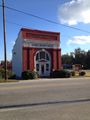
Shady Dale City Hall
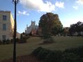
Georgia Old Capitol, Milledgeville

Picture of GPS


Achievements
Tomkf61 achieved level 3 of the Minesweeper Geohash achievement
|