Difference between revisions of "2013-11-08 41 -88"
imported>Mystrsyko |
m (per Renaming Proposal) |
||
| (7 intermediate revisions by 2 users not shown) | |||
| Line 18: | Line 18: | ||
== Expedition == | == Expedition == | ||
| − | + | Finding the hash point in a prairie near a public park, we decided that we must go for it, especially since it was only a 20 minute car ride from home. Unfortunately, I worked all day, scheduled to leave at 2am. My girlfriend, Dolphintreasure, still wanted to go for it (her first geohash!), so we made plans to head out after that. While this would mean that our expedition would technically be on the 9th, we reasoned that most hash points don't become valid until around 9am local time, and so we were still within 24 hours of the point being announced. Close enough. | |
| + | |||
| + | I didn't get out of work until 2:40, and by the time the two of us had packed up it was almost 4am. Caffeinated soda was bottled, and we headed out. We decided to park by a church nearby, it being the only public parking and sufficiently dark to conceal the car to passersby. Getting out, we were glad we doubled up on layers. The temperature was in the upper 30's, with a stiff breeze, and with it, the wind chill. Walking down Jericho Road, we pulled out the video camera and filmed for a bit, using the camera's on board light as a flashlight. | ||
| + | |||
| + | When we came to the intersection with Summerhill Drive, our plan had been to follow what looked like a path from aerial photos into the prairie and straight towards the hash. It turned out that what looked like a path was in fact just a straight section devoid of trees, but chock full of 8 foot tall prairie grasses. In the pitch dark, at 4am, with coyotes howling in the distance, it was decided that wandering blindly in was probably not a good idea. | ||
| + | |||
| + | The backup plan was to hike a bit into the subdivision down Summerhill to the public park just north of the hash and go cross country from there. It being 4:30am, we had no trouble avoiding detection and quickly reached the prairie at the edge of the park. I marked the hash in my gps with a waypoint and we bravely moved ahead at full cautiousness. Steadily making our way through the brush, which was now only 6 feet high, but shorter in places, we cautiously scanned what little distance we could see with our flashlights for animal life. The coyotes had us worried, especially since we were heading in their direction, although it seemed to our untrained ears that they were quite a distance away. | ||
| + | |||
| + | Gradually, we began to circle in closer to the hash point. The gps was not updating as often as we wanted, and so we had to frequently stop and wait for it to catch up. With somewhere around 50 feet to go, an unseen animal suddenly started moving in the brush to our west. Sufficiently frightened, and not wanting to chance hand to hand combat with a coyote at 5am, we bravely retreated back towards the park. So that was it, expedition over. | ||
== Photos == | == Photos == | ||
| − | |||
| − | |||
| − | |||
<gallery perrow="5"> | <gallery perrow="5"> | ||
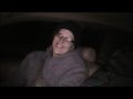
| + | Image:20131109_41-88.JPG |Mystrsyko driving | ||
| + | Image:20131109_41-88_2.JPG | Dolphintreasure happy to not be coyote food | ||
| + | Image:20131108gps.png | As close as we got :( | ||
</gallery> | </gallery> | ||
== Achievements == | == Achievements == | ||
| − | {{ | + | {{done with nature |
| − | |||
| + | | latitude = 41 | ||
| + | | longitude = -88 | ||
| + | | date = 2013-11-08 | ||
| + | | name = [[User:Mystrsyko | Mystrsyko]] & [[User:Dolphintreasure | Dolphintreasure]] | ||
| − | + | }} | |
| − | + | ||
| − | [[ | + | {{Prize poultry |
| + | |||
| + | | latitude = 41 | ||
| + | | longitude = -88 | ||
| + | | date = 2013-11-08 | ||
| + | | name = [[User:Mystrsyko | Mystrsyko]] & [[User:Dolphintreasure | Dolphintreasure]] | ||
| + | | reason = there were ninja coyotes | ||
| + | |||
| + | }} | ||
| − | |||
| − | |||
| − | |||
| − | |||
| − | |||
[[Category:Expeditions]] | [[Category:Expeditions]] | ||
| − | |||
[[Category:Expeditions with photos]] | [[Category:Expeditions with photos]] | ||
| − | |||
| − | |||
| − | |||
| − | |||
| − | |||
| − | |||
| − | |||
| − | |||
| − | |||
[[Category:Coordinates not reached]] | [[Category:Coordinates not reached]] | ||
| − | |||
| − | |||
[[Category:Not reached - Mother Nature]] | [[Category:Not reached - Mother Nature]] | ||
| − | + | {{location|US|IL|KE}} | |
| − | |||
| − | |||
| − | |||
| − | |||
| − | |||
| − | |||
| − | |||
| − | |||
| − | |||
| − | |||
Latest revision as of 14:32, 2 April 2024
| Fri 8 Nov 2013 in 41,-88: 41.7449278, -88.3824276 geohashing.info google osm bing/os kml crox |
Location
Near a park in Aurora
Participants
Plans
To head out after work, even if that's technically after midnight
Expedition
Finding the hash point in a prairie near a public park, we decided that we must go for it, especially since it was only a 20 minute car ride from home. Unfortunately, I worked all day, scheduled to leave at 2am. My girlfriend, Dolphintreasure, still wanted to go for it (her first geohash!), so we made plans to head out after that. While this would mean that our expedition would technically be on the 9th, we reasoned that most hash points don't become valid until around 9am local time, and so we were still within 24 hours of the point being announced. Close enough.
I didn't get out of work until 2:40, and by the time the two of us had packed up it was almost 4am. Caffeinated soda was bottled, and we headed out. We decided to park by a church nearby, it being the only public parking and sufficiently dark to conceal the car to passersby. Getting out, we were glad we doubled up on layers. The temperature was in the upper 30's, with a stiff breeze, and with it, the wind chill. Walking down Jericho Road, we pulled out the video camera and filmed for a bit, using the camera's on board light as a flashlight.
When we came to the intersection with Summerhill Drive, our plan had been to follow what looked like a path from aerial photos into the prairie and straight towards the hash. It turned out that what looked like a path was in fact just a straight section devoid of trees, but chock full of 8 foot tall prairie grasses. In the pitch dark, at 4am, with coyotes howling in the distance, it was decided that wandering blindly in was probably not a good idea.
The backup plan was to hike a bit into the subdivision down Summerhill to the public park just north of the hash and go cross country from there. It being 4:30am, we had no trouble avoiding detection and quickly reached the prairie at the edge of the park. I marked the hash in my gps with a waypoint and we bravely moved ahead at full cautiousness. Steadily making our way through the brush, which was now only 6 feet high, but shorter in places, we cautiously scanned what little distance we could see with our flashlights for animal life. The coyotes had us worried, especially since we were heading in their direction, although it seemed to our untrained ears that they were quite a distance away.
Gradually, we began to circle in closer to the hash point. The gps was not updating as often as we wanted, and so we had to frequently stop and wait for it to catch up. With somewhere around 50 feet to go, an unseen animal suddenly started moving in the brush to our west. Sufficiently frightened, and not wanting to chance hand to hand combat with a coyote at 5am, we bravely retreated back towards the park. So that was it, expedition over.
Photos

Mystrsyko driving
Dolphintreasure happy to not be coyote food
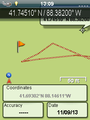
As close as we got :(


Achievements
Mystrsyko & Dolphintreasure earned the Done with Nature consolation prize
|
Mystrsyko & Dolphintreasure earned the Prize poultry Consolation Prize
|