Difference between revisions of "2013-11-09 43 -86"
imported>Mcbaneg (Created page with "<!-- If you did not specify these parameters in the template, please substitute appropriate values for IMAGE, LAT, LON, and DATE (YYYY-MM-DD format) [[{{{image|dummy.jpg}}}|...") |
m (per Renaming Proposal) |
||
| (11 intermediate revisions by 2 users not shown) | |||
| Line 28: | Line 28: | ||
We were headed northwest to visit friends on the lakeshore (that is, the Lake Michigan shore) overnight, | We were headed northwest to visit friends on the lakeshore (that is, the Lake Michigan shore) overnight, | ||
| − | and today's hashpoint was in the southeast corner of a graticule that is (1) | + | and today's hashpoint was in the southeast corner of a graticule that is (1) more than half water, (2) virgin, and (3) part of the set we need for a Minesweeper achievement. It looked easily accessible, but on private land a good ways behind an associated house, so it |
| − | seemed likely we would need to ask permission. | + | seemed likely we would need to ask permission. There was a white patch on the satmap that looked like a golf-course sand trap that I thought would be a small sandpit right next to the hashpoint. |
We found the house without difficulty, set just a little back from the road. There was a flag flying. We walked onto the | We found the house without difficulty, set just a little back from the road. There was a flag flying. We walked onto the | ||
| − | porch (past a No Solicitors) | + | porch (past a No Solicitors sign), and a small dog in the house started barking. A lady opened the door before we knocked |
| − | and looked quizzically at us: 51-year-old man and 14-year-old, and it's not Girl Scout Cookie season. I said we | + | and looked quizzically at us: 51-year-old man and 14-year-old girl, and it's not Girl Scout Cookie season. I said we wanted to ask her permission to walk through her backyard, and explained |
that we were playing a game where we tried to get to particular spots on the earth, and today's spot for our region was | that we were playing a game where we tried to get to particular spots on the earth, and today's spot for our region was | ||
at the back of her property near the sandpit. We showed her the Google map and pointed out her house and driveway, and she | at the back of her property near the sandpit. We showed her the Google map and pointed out her house and driveway, and she | ||
| − | then pointed near the hashpoint and said "and there's the pond". | + | then pointed near the hashpoint and said "and there's the pond". We chatted a little more and she somewhat reluctantly smiled and said "well, okay" and we thanked her and headed back there. There was in fact a tiny pond, and we |
| − | skirted around it and found the | + | skirted around it and found the hashpoint just west of what turned out to be a sandpile. Notice the compass picture showing that the south end of the sandpile is properly at 80 degrees from the hashpoint. In honor of [[User:Pastori|Pastori]] please note that it's a Finnish compass. |
| − | |||
| − | |||
| − | |||
| − | |||
| − | |||
| − | |||
| − | |||
| − | of | ||
| − | |||
| − | |||
== Photos == | == Photos == | ||
| Line 53: | Line 43: | ||
Image:2012-##-## ## ## Alpha.jpg | Witty Comment | Image:2012-##-## ## ## Alpha.jpg | Witty Comment | ||
--> | --> | ||
| − | <gallery perrow=" | + | <gallery perrow="6"> |
| − | Image:2013- | + | Image:2013-11-09 43 -86 1.jpg | Compass pointing toward end of sandpile(no batteries required.) |
| − | Image:2013- | + | Image:2013-11-09 43 -86 3.jpg | George showing compass pointing toward sandpile. |
| − | Image:2013-10- | + | Image:2013-11-09 43 -86 8.jpg | The pond. |
| + | Image:2013-11-09 43 -86 4.jpg | Rebekah at hashpoint. | ||
| + | Image:2013-11-09 43 -86 10.jpg | Stupid Grins. | ||
| + | Image:2013-11-09 43 -86 12.jpg | Lake Michigan later that day, looking south from the mouth of the Pentwater harbor. | ||
| + | |||
</gallery> | </gallery> | ||
| Line 63: | Line 57: | ||
<!-- Add any achievement ribbons you earned below, or remove this section --> | <!-- Add any achievement ribbons you earned below, or remove this section --> | ||
| + | {{Ambassador geohash | ||
| + | | latitude = 43 | ||
| + | | longitude = -86 | ||
| + | | date = 2013-11-09 | ||
| + | | granter = the Lady of the House | ||
| + | | name = George and Rebekah | ||
| + | }} | ||
{{land geohash | {{land geohash | ||
| − | | latitude = | + | | latitude = 43 |
| longitude = -86 | | longitude = -86 | ||
| − | | date = 2013- | + | | date = 2013-11-09 |
| − | | name = George | + | | name = George and Rebekah |
}} | }} | ||
{{no batteries geohash | {{no batteries geohash | ||
| − | | latitude = | + | | latitude = 43 |
| − | |||
| − | |||
| − | |||
| − | |||
| − | |||
| − | |||
| longitude = -86 | | longitude = -86 | ||
| − | | date = 2013- | + | | date = 2013-11-09 |
| − | + | | name = George and Rebekah | |
| − | | name = | ||
}} | }} | ||
| − | + | {{Graticule unlocked | |
| − | {{ | + | | latitude = 43 |
| − | | latitude = | ||
| longitude = -86 | | longitude = -86 | ||
| − | | date = 2013- | + | | date = 2013-11-09 |
| − | | name = George | + | | name = George and Rebekah |
}} | }} | ||
| Line 99: | Line 92: | ||
[[Category:Expeditions with photos]] | [[Category:Expeditions with photos]] | ||
[[Category:Coordinates reached]] | [[Category:Coordinates reached]] | ||
| + | {{location|US|MI|MG}} | ||
Latest revision as of 05:18, 20 March 2024

| Sat 9 Nov 2013 in 43,-86: 43.1787627, -86.0892742 geohashing.info google osm bing/os kml crox |
Location
rural property in Fruitport, MI, USA
Participants
Expedition
We were headed northwest to visit friends on the lakeshore (that is, the Lake Michigan shore) overnight, and today's hashpoint was in the southeast corner of a graticule that is (1) more than half water, (2) virgin, and (3) part of the set we need for a Minesweeper achievement. It looked easily accessible, but on private land a good ways behind an associated house, so it seemed likely we would need to ask permission. There was a white patch on the satmap that looked like a golf-course sand trap that I thought would be a small sandpit right next to the hashpoint.
We found the house without difficulty, set just a little back from the road. There was a flag flying. We walked onto the porch (past a No Solicitors sign), and a small dog in the house started barking. A lady opened the door before we knocked and looked quizzically at us: 51-year-old man and 14-year-old girl, and it's not Girl Scout Cookie season. I said we wanted to ask her permission to walk through her backyard, and explained that we were playing a game where we tried to get to particular spots on the earth, and today's spot for our region was at the back of her property near the sandpit. We showed her the Google map and pointed out her house and driveway, and she then pointed near the hashpoint and said "and there's the pond". We chatted a little more and she somewhat reluctantly smiled and said "well, okay" and we thanked her and headed back there. There was in fact a tiny pond, and we skirted around it and found the hashpoint just west of what turned out to be a sandpile. Notice the compass picture showing that the south end of the sandpile is properly at 80 degrees from the hashpoint. In honor of Pastori please note that it's a Finnish compass.
Photos
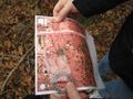
Compass pointing toward end of sandpile(no batteries required.)
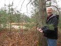
George showing compass pointing toward sandpile.
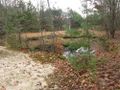
The pond.

Rebekah at hashpoint.

Stupid Grins.
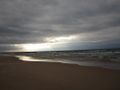
Lake Michigan later that day, looking south from the mouth of the Pentwater harbor.


Achievements
George and Rebekah earned the Ambassador achievement
|
George and Rebekah earned the Land geohash achievement
|
George and Rebekah earned the No Batteries Geohash Achievement
|
George and Rebekah earned the Graticule Unlocked Achievement
|