Difference between revisions of "2013-11-18 51 9"
imported>GeorgDerReisende (expedition report) |
imported>GeorgDerReisende (just found this) |
||
| Line 39: | Line 39: | ||
<!-- Add any achievement ribbons you earned below, or remove this section --> | <!-- Add any achievement ribbons you earned below, or remove this section --> | ||
| + | {{Cliffs of Despair | [[User:GeorgDerReisende|GeorgDerReisende]] | latitude = 51 | longitude = 9 | date = 2013-11-18}} | ||
[[Category:Expeditions]] | [[Category:Expeditions]] | ||
Revision as of 15:07, 19 November 2013
| Mon 18 Nov 2013 in 51,9: 51.4122599, 9.6755435 geohashing.info google osm bing/os kml crox |
Location
The hash lies in the forest at the eastern side of Hann. Münden.
Participants
Plans
I wanted to hitchhike to Hann. Münden, walking to the hash, walking through the city, and hitchhike home.
Expedition
It was a grey day again. I left home at about 13:30. I started to hitchhike at 14:00 and got a lift to Hann. Münden after 15 minutes. I arrived there at 14:35. Then I walked to the hash. At 15:13 I noticed that I am near the hash. But I was 30 meters away, and the hash was steep down the hill. I took some photos of the place and returned to home. I started to hitchhike at 15:43, got a lift after ten minutes and arrived in Kassel at 16:15.
Photos
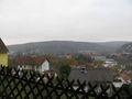
View to Hann. Münden
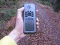
proof1
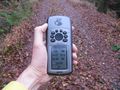
proof2
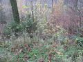
there is the hash, 30 meters away, and deep down the hill
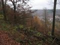
another view to the hash and the situation
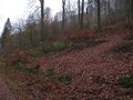
so does it look up the hill
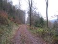
the way from and to Hann. Münden
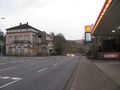
the place where I started to hitchhike home


Achievements
This user earned the Cliffs of Despair consolation prize
|