Difference between revisions of "2013-11-19 49 -122"
From Geohashing
imported>Rex Wolf (Uploaded expedition report) |
m (More specific location) |
||
| (4 intermediate revisions by 2 users not shown) | |||
| Line 45: | Line 45: | ||
--> | --> | ||
<gallery perrow="5"> | <gallery perrow="5"> | ||
| + | Image:Rex-Surrey-2013-11-19-1.JPG | The end of the road... | ||
| + | Image:Rex-Surrey-2013-11-19-2.JPG | ...but we can't go any further. | ||
| + | Image:Rex-Surrey-2013-11-19-3.JPG | Is this an abandoned treasure chest?. | ||
| + | Image:Rex-Surrey-2013-11-19-4.JPG | Perhaps a burial cairn? | ||
| + | Image:Rex-Surrey-2013-11-19-5.PNG | This is as far as we got. | ||
</gallery> | </gallery> | ||
| Line 55: | Line 60: | ||
| date = 2013-11-19 | | date = 2013-11-19 | ||
| name = [[User:Rex Wolf|Rex]] | | name = [[User:Rex Wolf|Rex]] | ||
| − | + | | image = Rex-Surrey-2013-11-19-2.JPG | |
| distance = 121m | | distance = 121m | ||
}} | }} | ||
| Line 99: | Line 104: | ||
(Don't forget to delete this final close comment marker) --> | (Don't forget to delete this final close comment marker) --> | ||
| + | {{location|CA|BC|MV}} | ||
Latest revision as of 00:03, 10 August 2020
| Tue 19 Nov 2013 in Surrey: 49.1035562, -122.8117001 geohashing.info google osm bing/os kml crox |
Location
In a field by 148th and 56th.
Participants
Plans
We decided to swing by after work, providing it wasn't raining.
Expedition
It wasn't raining, so we headed out for the hashpoint on our way home from work. We drove as far as we could, but when we parked and got out to walk into the field, we almost immediately ran into a "Private Property" sign. Foiled again!
Tracklog
Photos
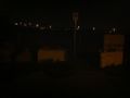
The end of the road...
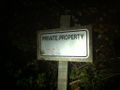
...but we can't go any further.

Is this an abandoned treasure chest?.
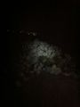
Perhaps a burial cairn?
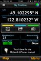
This is as far as we got.


Achievements
Rex earned the No trespassing consolation prize
|