Difference between revisions of "2013-11-27 42 -112"
From Geohashing
imported>Eldin (add pictures and fill in details.) |
imported>FippeBot m (Location) |
||
| Line 36: | Line 36: | ||
[[Category:Expeditions with photos]] | [[Category:Expeditions with photos]] | ||
[[Category:Coordinates reached]] | [[Category:Coordinates reached]] | ||
| + | {{location|US|ID|ON}} | ||
Revision as of 06:46, 6 August 2019
| Wed 27 Nov 2013 in 42,-112: 42.0659423, -112.9097505 geohashing.info google osm bing/os kml crox |
Location
Just west of I-84
Participants
Plans
Before heading out to visit my parents for the Thanksgiving holiday, I checked the day's hashes. This one was too close to my route to pass up.
Expedition
We pulled off at a rest area and parked about 3300ft from the hash. My wife opted to stay in the car while I headed out to the hashpoint. Navigating across uneven ground and around juniper trees in the dark was mildly challenging, but the hash was reached without incident. In total I walked about 1.5 miles, which took just over half an hour.
- At the hash! Another virgin graticule falls! -- Eldin (talk) @42.0660,-112.9097 19:23, 27 November 2013 (MST)
Photos
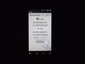
Proof.

Grin.
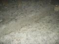
This trail ran within GPS error of the spot, but roughly perpendicular to the line between the hash and where I parked.


Achievements
Eldin earned the Land geohash achievement
|