Difference between revisions of "2013-11-29 43 -121"
imported>Benture (→Achievements) |
imported>FippeBot m (Location) |
||
| (5 intermediate revisions by 2 users not shown) | |||
| Line 15: | Line 15: | ||
}} | }} | ||
| − | + | \ | |
__NOTOC__ | __NOTOC__ | ||
== Location == | == Location == | ||
| Line 24: | Line 24: | ||
*[[User:Benture|Benture]] | *[[User:Benture|Benture]] | ||
*Frogman's Grandpa | *Frogman's Grandpa | ||
| + | *Daisy | ||
== Plans == | == Plans == | ||
| Line 29: | Line 30: | ||
== Expedition == | == Expedition == | ||
| − | + | We drove down to La Pine and parked our car just outside of town on Boundary Road. After a bit of trailblazing we came across a network of roads that ended up bringing us within about 30 meters of the hashpoint. From there it was an easy hike to the hashpoint! We snapped a couple photos and headed back to the car. | |
| + | |||
| + | Our canine expedition member, Daisy, had a wonderful time running up and down the roads, making sure to pick up every stick she could. She was very tired afterwards! | ||
== Tracklog == | == Tracklog == | ||
| Line 35: | Line 38: | ||
== Photos == | == Photos == | ||
| − | + | ||
| − | |||
| − | |||
<gallery perrow="5"> | <gallery perrow="5"> | ||
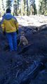
| + | Image:2013-11-29 43 -121 driving.jpg | On the way there! | ||
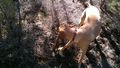
| + | Image:2013-11-29 43 -121 daisy.jpg | Daisy had a grand time. There were so many sticks to bite. | ||
| + | Image:2013-11-29 43 -121 hashpoint.jpg | [[User:Frogman|Frogman]] at the hashpoint! | ||
| + | Image:2013-11-29 43 -121 proof.jpg | Proof! | ||
| + | Image:2013-11-29 43 -121 grins.jpg | Goofy grins. | ||
| + | Image:2013-11-29 43 -121 daisyatthehashpoint.jpg | Daisy found more sticks at the hashpoint. | ||
| + | Image:2013-11-29 43 -121 pleasepayattentiontome.jpg | What did Daisy find on the walk home? | ||
| + | Image:2013-11-29 43 -121 bone.jpg | A jawbone! | ||
| + | Image:2013-11-29 43 -121 hoof.jpg | We found an elk hoof and scapula. | ||
</gallery> | </gallery> | ||
== Achievements == | == Achievements == | ||
{{#vardefine:ribbonwidth|800px}} | {{#vardefine:ribbonwidth|800px}} | ||
| − | + | ||
{{land geohash | {{land geohash | ||
| latitude = 43 | | latitude = 43 | ||
| Line 49: | Line 59: | ||
| date = 2013-11-29 | | date = 2013-11-29 | ||
| name = Benture | | name = Benture | ||
| − | |||
}} | }} | ||
| − | |||
| − | |||
| − | |||
| − | |||
| − | |||
| − | |||
| − | |||
| − | |||
| − | |||
| − | |||
[[Category:Expeditions]] | [[Category:Expeditions]] | ||
| − | |||
[[Category:Expeditions with photos]] | [[Category:Expeditions with photos]] | ||
| − | |||
| − | |||
| − | |||
| − | |||
| − | |||
[[Category:Coordinates reached]] | [[Category:Coordinates reached]] | ||
| − | + | {{location|US|OR|DE}} | |
| − | |||
| − | |||
| − | |||
| − | |||
| − | |||
| − | |||
| − | |||
| − | |||
| − | |||
| − | |||
| − | |||
| − | |||
| − | |||
| − | |||
| − | |||
| − | |||
| − | |||
Latest revision as of 04:46, 14 August 2019
| Fri 29 Nov 2013 in 43,-121: 43.7362086, -121.5545612 geohashing.info google osm bing/os kml crox |
\
Location
In the Deschutes National Forest just west of La Pine, Oregon.
Participants
Plans
We were in the area for Thanksgiving weekend and saw that this geohash was doable!
Expedition
We drove down to La Pine and parked our car just outside of town on Boundary Road. After a bit of trailblazing we came across a network of roads that ended up bringing us within about 30 meters of the hashpoint. From there it was an easy hike to the hashpoint! We snapped a couple photos and headed back to the car.
Our canine expedition member, Daisy, had a wonderful time running up and down the roads, making sure to pick up every stick she could. She was very tired afterwards!
Tracklog
Photos
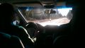
On the way there!
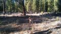
Daisy had a grand time. There were so many sticks to bite.
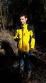
Frogman at the hashpoint!
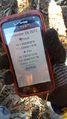
Proof!
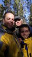
Goofy grins.
Daisy found more sticks at the hashpoint.
What did Daisy find on the walk home?
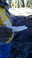
A jawbone!
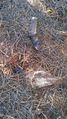
We found an elk hoof and scapula.


Achievements
Benture earned the Land geohash achievement
|