Difference between revisions of "2013-12-06 43 -116"
imported>Eldin ([live] At the hash! Cold and windy.) |
imported>Eldin (fill in details and add photos.) |
||
| Line 1: | Line 1: | ||
| − | |||
| − | |||
| − | |||
| − | |||
| − | |||
| − | |||
| − | |||
| − | |||
| − | |||
| − | |||
{{meetup graticule | {{meetup graticule | ||
| lat=43 | | lat=43 | ||
| Line 15: | Line 5: | ||
}} | }} | ||
| − | + | ||
__NOTOC__ | __NOTOC__ | ||
== Location == | == Location == | ||
| − | + | Just west of Swan Falls Rd, south of Kuna. | |
== Participants == | == Participants == | ||
| − | + | * [[User:Eldin|Eldin]] | |
| − | |||
| − | |||
| − | |||
| − | |||
== Expedition == | == Expedition == | ||
| − | + | This was a fairly easy hash to reach. Except for the tumbleweeds. the dirt road I took once I pulled off of Swan Falls Rd was worn down as much as 3 feet below the surrounding ground. In places, it had completely filled with tumbleweeds. At one point while trying to drive through them, I managed to pile up so many in front of me that they came up over the front of the car and covered my windshield. I had to get out of the car and remove them by hand. And of course, these were the thorny variety of tumbleweed, which made that task doubly fun. Dealing with the tumbleweeds cost me about 15 minutes extra on this hash, and a few new minor scratches in the car. I was able to pull off the track about 700ft from the hash. The ground was uneven and had patches of snow. It took about 10 minutes to reach the spot, where I took some photos and posted my success. Then I headed back towards the car. When I had nearly reached it, I stepped in a burrow of some sort that I'd failed to notice previously and fell, resulting in a very minorly twisted ankle, and a skinned spot on my hand. | |
| + | Even though the temperature wasn't as low as yesterday's hash, with the wind it felt quite a bit colder. Fortunately, I chose to bring a warmer coat, and remembered my hat and gloves for this expedition, so it wasn't too bad. | ||
*At the hash! Cold and windy. -- [[User:Eldin|Eldin]] ([[User talk:Eldin|talk]]) [http://www.openstreetmap.org/?lat=43.36572720&lon=-116.42042015&zoom=16&layers=B000FTF @43.3657,-116.4204] 20:24, 6 December 2013 (MST) | *At the hash! Cold and windy. -- [[User:Eldin|Eldin]] ([[User talk:Eldin|talk]]) [http://www.openstreetmap.org/?lat=43.36572720&lon=-116.42042015&zoom=16&layers=B000FTF @43.3657,-116.4204] 20:24, 6 December 2013 (MST) | ||
| − | |||
| − | |||
== Photos == | == Photos == | ||
| − | |||
| − | |||
| − | |||
<gallery perrow="5"> | <gallery perrow="5"> | ||
| + | File:2013-12-06 43 -116 proof.jpg | Proof that the hash was reached. | ||
| + | File:2013-12-06 43 -116 grin.jpg | Something like a grin. | ||
| + | File:2013-12-06 43 -116 point.jpg | The hashpoint. An unremarkable spot not easily distinguished from any of the surrounding area. | ||
| + | File:2013-12-06 43 -116 temp.jpg | Proof of freezing, about 700ft from the hash. | ||
</gallery> | </gallery> | ||
== Achievements == | == Achievements == | ||
{{#vardefine:ribbonwidth|800px}} | {{#vardefine:ribbonwidth|800px}} | ||
| − | + | {{Land geohash|latitude=43|longitude=-116|date=2013-12-06|name=[[User:Eldin|Eldin]]}}{{Frozen Geohash|latitude=43|longitude=-116|date=2013-12-06|temperature=21°F (-6°C)|name=[[User:Eldin|Eldin]]}} | |
| − | |||
| − | |||
| − | |||
| − | |||
| − | |||
| − | |||
| − | |||
| − | |||
| − | |||
| − | |||
[[Category:Expeditions]] | [[Category:Expeditions]] | ||
| − | |||
[[Category:Expeditions with photos]] | [[Category:Expeditions with photos]] | ||
| − | |||
| − | |||
| − | |||
| − | |||
| − | |||
[[Category:Coordinates reached]] | [[Category:Coordinates reached]] | ||
| − | |||
| − | |||
| − | |||
| − | |||
| − | |||
| − | |||
| − | |||
| − | |||
| − | |||
| − | |||
| − | |||
| − | |||
| − | |||
| − | |||
| − | |||
| − | |||
| − | |||
| − | |||
Revision as of 05:47, 7 December 2013
| Fri 6 Dec 2013 in 43,-116: 43.3657269, -116.4204189 geohashing.info google osm bing/os kml crox |
Location
Just west of Swan Falls Rd, south of Kuna.
Participants
Expedition
This was a fairly easy hash to reach. Except for the tumbleweeds. the dirt road I took once I pulled off of Swan Falls Rd was worn down as much as 3 feet below the surrounding ground. In places, it had completely filled with tumbleweeds. At one point while trying to drive through them, I managed to pile up so many in front of me that they came up over the front of the car and covered my windshield. I had to get out of the car and remove them by hand. And of course, these were the thorny variety of tumbleweed, which made that task doubly fun. Dealing with the tumbleweeds cost me about 15 minutes extra on this hash, and a few new minor scratches in the car. I was able to pull off the track about 700ft from the hash. The ground was uneven and had patches of snow. It took about 10 minutes to reach the spot, where I took some photos and posted my success. Then I headed back towards the car. When I had nearly reached it, I stepped in a burrow of some sort that I'd failed to notice previously and fell, resulting in a very minorly twisted ankle, and a skinned spot on my hand.
Even though the temperature wasn't as low as yesterday's hash, with the wind it felt quite a bit colder. Fortunately, I chose to bring a warmer coat, and remembered my hat and gloves for this expedition, so it wasn't too bad.
- At the hash! Cold and windy. -- Eldin (talk) @43.3657,-116.4204 20:24, 6 December 2013 (MST)
Photos

Proof that the hash was reached.

Something like a grin.
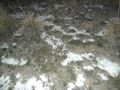
The hashpoint. An unremarkable spot not easily distinguished from any of the surrounding area.
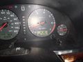
Proof of freezing, about 700ft from the hash.


Achievements
Eldin earned the Land geohash achievement
|
