Difference between revisions of "2013-12-07 40 -73"
imported>Elipongo ([live picture] My silly smiling face at the location. [http://www.openstreetmap.org/?lat=40.84933670&lon=-73.82806992&zoom=16&layers=B000FTF @40.8493,-73.8281]) |
imported>FippeBot m (Location) |
||
| (11 intermediate revisions by 2 users not shown) | |||
| Line 43: | Line 43: | ||
*Off the train and walking the last block -- [[User:Elipongo|Elipongo]] ([[User talk:Elipongo|talk]]) [http://www.openstreetmap.org/?lat=40.85202983&lon=-73.82728282&zoom=16&layers=B000FTF @40.8520,-73.8273] 23:41, 7 December 2013 (EST) | *Off the train and walking the last block -- [[User:Elipongo|Elipongo]] ([[User talk:Elipongo|talk]]) [http://www.openstreetmap.org/?lat=40.85202983&lon=-73.82728282&zoom=16&layers=B000FTF @40.8520,-73.8273] 23:41, 7 December 2013 (EST) | ||
| + | |||
| + | As my real time comments above allude, I took the New York City Subway to the location. | ||
| + | |||
| + | I hopped on the 1 Train at 86th St, then transferred to the 2 Train at 96th St. I detrained at Simpson St and walked the couple blocks to the 6 Train at Hunt's Point Ave (that should be a free transfer, the stations are SO close!) I rode until we reached the end of the line - Pelham Bay Park Terminal Station (Made famous by the novel and Movies ''The Taking of Pelham One Two Three''.) | ||
| + | |||
| + | From there it was a five minute walk to the location. It was on the sidewalk in front of the parking lot of a lovely Greek Orthodox church, and a strangely empty I-95 was right across the street! | ||
| + | |||
| + | It was cold, 30 degrees F with a 10mph North wind. I didn't linger. Besides, I had to get to the nearby Sunday location. | ||
| + | |||
| + | The saga continues at [[2013-12-08 40 -73]] | ||
| + | |||
| + | *Addendum: Even though I didn't go to see it, a nearby landmark was quite appropriate for thIs Pearl Harbor Day geohash: The Bronx Victory Column & Memorial Grove - https://en.wikipedia.org/wiki/The_Bronx_Victory_Column_%26_Memorial_Grove | ||
| + | |||
== Tracklog == | == Tracklog == | ||
<!-- if your GPS device keeps a log, you may post a link here --> | <!-- if your GPS device keeps a log, you may post a link here --> | ||
| Line 57: | Line 70: | ||
Image:2013-12-07_40_-73_23-50-35-449.jpg | My silly smiling face at the location. [http://www.openstreetmap.org/?lat=40.84933670&lon=-73.82806992&zoom=16&layers=B000FTF @40.8493,-73.8281] | Image:2013-12-07_40_-73_23-50-35-449.jpg | My silly smiling face at the location. [http://www.openstreetmap.org/?lat=40.84933670&lon=-73.82806992&zoom=16&layers=B000FTF @40.8493,-73.8281] | ||
| + | |||
| + | Image:2013-12-07_40_-73_23-51-20-162.jpg | Interstate 95 is right across the street [http://www.openstreetmap.org/?lat=40.84830000&lon=-73.82690000&zoom=16&layers=B000FTF @40.8483,-73.8269] | ||
| + | |||
| + | Image:2013-12-07_40_-73_23-51-56-583.jpg | The Lovely church right at location [http://www.openstreetmap.org/?lat=40.84940000&lon=-73.82810000&zoom=16&layers=B000FTF @40.8494,-73.8281] | ||
| + | |||
| + | Image:2013-12-07_40_-73_23-57-18-530.jpg | Ah there's the name of the church [http://www.openstreetmap.org/?lat=40.85000000&lon=-73.82780000&zoom=16&layers=B000FTF @40.8500,-73.8278] | ||
| + | |||
| + | Image:2013-12-07_40_-73_05-20-50-379.jpg | I can't believe I forgot to upload this before! | ||
| + | |||
| + | Image:2013-12-07_40_-73_05-21-14-668.jpg | I can't believe I forgot to upload this before! | ||
</gallery> | </gallery> | ||
| Line 62: | Line 85: | ||
{{#vardefine:ribbonwidth|800px}} | {{#vardefine:ribbonwidth|800px}} | ||
<!-- Add any achievement ribbons you earned below, or remove this section --> | <!-- Add any achievement ribbons you earned below, or remove this section --> | ||
| + | {{land geohash| latitude = 40| longitude = -73| date = 2013-12-07| name = elipongo}} | ||
| + | {{Public transport geohash| latitude = 40| longitude = -73| date = 2013-12-07| busline = The NYC Subway's 2 & 6 trains| name = elipongo}} | ||
| − | + | {{Frozen Geohash| latitude = 40| longitude = -73| date = 2013-12-07| temperature = 30°F| name = elipongo}} | |
| − | |||
| − | |||
| − | |||
| − | |||
| − | |||
| − | |||
| − | |||
| − | |||
[[Category:Expeditions]] | [[Category:Expeditions]] | ||
| − | |||
[[Category:Expeditions with photos]] | [[Category:Expeditions with photos]] | ||
| − | |||
| − | |||
| − | |||
| − | |||
[[Category:Coordinates reached]] | [[Category:Coordinates reached]] | ||
| − | + | {{location|US|NY|BN}} | |
| − | |||
| − | |||
| − | |||
| − | |||
| − | |||
| − | |||
| − | |||
| − | |||
| − | |||
| − | |||
| − | |||
| − | |||
| − | |||
| − | |||
| − | |||
| − | |||
| − | |||
Latest revision as of 04:50, 14 August 2019
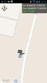
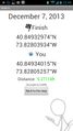
| Sat 7 Dec 2013 in 40,-73: 40.8493297, -73.8280393 geohashing.info google osm bing/os kml crox |
Location
Nearby 3573 Bruckner Blvd, Bronx NY.
It appears to be on the sidewalk by the parking lot.
Participants
Plans
When I saw that both the Saturday and Sunday geohash locations this weekend were in the Bronx, and were furthermore close both to each other and also to stations on the Six Train, I determined to get both of them in one shot.
The Saturday geohash looks easy enough to access; the sidewalk by a church parking lot off of Bruckner Blvd. I plan to be there around 11:15pm-ish.--Elipongo (talk) 18:48, 7 December 2013 (EST)
Expedition
- On the two train on the way there! Why is this train ALWAYS crowded? -- Elipongo (talk) @40.8198,-73.9010 23:00, 7 December 2013 (EST)
- Transferring to the 6 train now. -- Elipongo (talk) @40.8211,-73.8939 23:08, 7 December 2013 (EST)
- Off the train and walking the last block -- Elipongo (talk) @40.8520,-73.8273 23:41, 7 December 2013 (EST)
As my real time comments above allude, I took the New York City Subway to the location.
I hopped on the 1 Train at 86th St, then transferred to the 2 Train at 96th St. I detrained at Simpson St and walked the couple blocks to the 6 Train at Hunt's Point Ave (that should be a free transfer, the stations are SO close!) I rode until we reached the end of the line - Pelham Bay Park Terminal Station (Made famous by the novel and Movies The Taking of Pelham One Two Three.)
From there it was a five minute walk to the location. It was on the sidewalk in front of the parking lot of a lovely Greek Orthodox church, and a strangely empty I-95 was right across the street!
It was cold, 30 degrees F with a 10mph North wind. I didn't linger. Besides, I had to get to the nearby Sunday location.
The saga continues at 2013-12-08 40 -73
- Addendum: Even though I didn't go to see it, a nearby landmark was quite appropriate for thIs Pearl Harbor Day geohash: The Bronx Victory Column & Memorial Grove - https://en.wikipedia.org/wiki/The_Bronx_Victory_Column_%26_Memorial_Grove
Tracklog
Photos
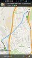
Both today's and Sunday's locations are in the Bronx, near each other, and both nearby the Six Train!
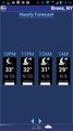
It looks to be clear, but chilly & windy during my visit.

My silly smiling face at the location. @40.8493,-73.8281
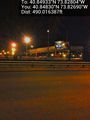
Interstate 95 is right across the street @40.8483,-73.8269
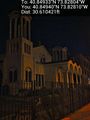
The Lovely church right at location @40.8494,-73.8281
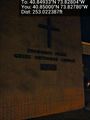
Ah there's the name of the church @40.8500,-73.8278
I can't believe I forgot to upload this before!
I can't believe I forgot to upload this before!


Achievements
elipongo earned the Land geohash achievement
|
elipongo earned the Public transport geohash achievement
|
