Difference between revisions of "2013-12-08 32 -116"
From Geohashing
imported>LucasBrown |
imported>LucasBrown (→Achievements) |
||
| Line 16: | Line 16: | ||
== Achievements == | == Achievements == | ||
{{#vardefine:ribbonwidth|800px}} | {{#vardefine:ribbonwidth|800px}} | ||
| − | + | {{Consecutive geohash | count = 2 | latitude = 32 | longitude = -116 | date = 2013-12-08 | name = LucasBrown}} | |
| + | (See also [[2013-12-09 32 -117]]) | ||
[[Category:Expeditions]] | [[Category:Expeditions]] | ||
[[Category:Expeditions with photos]] | [[Category:Expeditions with photos]] | ||
[[Category:Coordinates reached]] | [[Category:Coordinates reached]] | ||
Revision as of 01:14, 10 December 2013
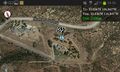
| Sun 8 Dec 2013 in 32,-116: 32.8360001, -116.8410924 geohashing.info google osm bing/os kml crox |
Location
Just below Montana Serena Road overlooking Harbison Canyon in San Diego County, CA
Participants
Photos
Map at hashpoint
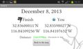
Geohash Droid details page at the hashpoint


Achievements
LucasBrown earned the Consecutive geohash achievement
|
(See also 2013-12-09 32 -117)