Difference between revisions of "2013-12-11 43 -116"
imported>Eldin (Created page with "{{subst:User:Eldin/template/Expedition |lat = 43 |lon = -116 |date = 2013-12-11 |location = A bit off Little Freezeout Rd, North of Middleton. |participants = * User:Eldin...") |
imported>Eldin (add photographs.) |
||
| Line 1: | Line 1: | ||
| − | |||
| − | |||
| − | |||
| − | |||
| − | |||
| − | |||
| − | |||
| − | |||
| − | |||
| − | |||
{{meetup graticule | {{meetup graticule | ||
| lat=43 | | lat=43 | ||
| Line 15: | Line 5: | ||
}} | }} | ||
| − | |||
__NOTOC__ | __NOTOC__ | ||
| Line 32: | Line 21: | ||
== Photos == | == Photos == | ||
| − | |||
| − | |||
| − | |||
<gallery perrow="5"> | <gallery perrow="5"> | ||
| + | File:2013-12-11 43 -116 proof.jpg | Proof of reaching the coordinates. | ||
| + | File:2013-12-11 43 -116 grin.jpg | Grinning geohasher. | ||
| + | File:2013-12-11 43 -116 spot.jpg | The hashpoint is roughly on the crude X seen here. | ||
| + | File:2013-12-11 43 -116 temp.jpg | Proof of freezing temperature near the hashpoint. | ||
| + | File:2013-12-11 43 -116 hole.jpg | The burrow I stepped in. It's easy to see now, but with weeds and snow on top, it was hard to notice. | ||
</gallery> | </gallery> | ||
== Achievements == | == Achievements == | ||
{{#vardefine:ribbonwidth|800px}} | {{#vardefine:ribbonwidth|800px}} | ||
| − | {{Land geohash|latitude=43|longitude=-116|date=2013-12-11|name=[[User:Eldin|Eldin]]}}{{Frozen Geohash|latitude=43|longitude=-116|date=2013-12-11|temperature=9°F (-12.8°C)|name=[[User:Eldin|Eldin]]}} | + | {{Land geohash|latitude=43|longitude=-116|date=2013-12-11|name=[[User:Eldin|Eldin]]}} |
| − | + | {{Frozen Geohash|latitude=43|longitude=-116|date=2013-12-11|temperature=9°F (-12.8°C)|name=[[User:Eldin|Eldin]]}} | |
| − | |||
| − | |||
| − | |||
| − | |||
| − | |||
| − | |||
| − | |||
| − | |||
| − | |||
[[Category:Expeditions]] | [[Category:Expeditions]] | ||
| − | |||
[[Category:Expeditions with photos]] | [[Category:Expeditions with photos]] | ||
| − | |||
| − | |||
| − | |||
| − | |||
| − | |||
[[Category:Coordinates reached]] | [[Category:Coordinates reached]] | ||
| − | |||
| − | |||
| − | |||
| − | |||
| − | |||
| − | |||
| − | |||
| − | |||
| − | |||
| − | |||
| − | |||
| − | |||
| − | |||
| − | |||
| − | |||
| − | |||
| − | |||
| − | |||
Revision as of 05:31, 12 December 2013
| Wed 11 Dec 2013 in 43,-116: 43.7965807, -116.6481326 geohashing.info google osm bing/os kml crox |
Location
A bit off Little Freezeout Rd, North of Middleton.
Participants
Expedition
Being only about 330 ft from the road, this hash was fairly easy to reach. I drove out to it after work, parked my car on the side of the road, and walked out to the hash. The only event of note was stepping in a burrow that had been concealed by the snow. I was fortunate that this did not result in a serious injury, but only bruised my shin. Watching for other hidden holes slowed down my progress somewhat. However, I reached the hash without further incident. There were other recent footprints in the snow within 30 ft of the hashpoint, but I didn't find any which went closer than that. At the hash, I stomped the snow down to roughly form the letters XKCD, took some pictures, and headed back to my car.
Photos
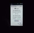
Proof of reaching the coordinates.
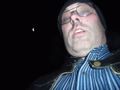
Grinning geohasher.
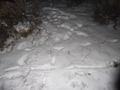
The hashpoint is roughly on the crude X seen here.
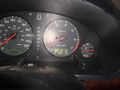
Proof of freezing temperature near the hashpoint.
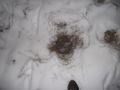
The burrow I stepped in. It's easy to see now, but with weeds and snow on top, it was hard to notice.


Achievements
Eldin earned the Land geohash achievement
|
