Difference between revisions of "2013-12-14 40 -74"
From Geohashing
imported>Jevanyn ([live picture] 6 Dibert Rd. [http://www.openstreetmap.org/?lat=40.96528313&lon=-74.64644859&zoom=16&layers=B000FTF @40.9653,-74.6464]) |
imported>FippeBot m (Location) |
||
| (3 intermediate revisions by one other user not shown) | |||
| Line 18: | Line 18: | ||
__NOTOC__ | __NOTOC__ | ||
== Location == | == Location == | ||
| − | + | Lake Hopatcong | |
== Participants == | == Participants == | ||
| − | + | [[User:Jevanyn|Jevanyn]] ([[User talk:Jevanyn|talk]]) | |
| − | |||
== Plans == | == Plans == | ||
| − | + | Swing by before heading home from work. Hopefully I could get a few lake pictures before it gets too dark. | |
== Expedition == | == Expedition == | ||
| − | |||
| − | |||
| − | |||
*North shore of Lake Hopatcong. That's actually not far from where I work, maybe I'll go today. -- [[User:Jevanyn|Jevanyn]] ([[User talk:Jevanyn|talk]]) 10:28, 13 December 2013 (EST) | *North shore of Lake Hopatcong. That's actually not far from where I work, maybe I'll go today. -- [[User:Jevanyn|Jevanyn]] ([[User talk:Jevanyn|talk]]) 10:28, 13 December 2013 (EST) | ||
*I made it, and before the light completely failed, too. It's behind the house, which is for sale but still occupied. I'm heading back down the hill to get a picture across frozen Lake Hopatcong, then heading home. -- [[User:Jevanyn|Jevanyn]] ([[User talk:Jevanyn|talk]]) [http://www.openstreetmap.org/?lat=40.96529053&lon=-74.64644411&zoom=16&layers=B000FTF @40.9653,-74.6464] 16:59, 13 December 2013 (EST) | *I made it, and before the light completely failed, too. It's behind the house, which is for sale but still occupied. I'm heading back down the hill to get a picture across frozen Lake Hopatcong, then heading home. -- [[User:Jevanyn|Jevanyn]] ([[User talk:Jevanyn|talk]]) [http://www.openstreetmap.org/?lat=40.96529053&lon=-74.64644411&zoom=16&layers=B000FTF @40.9653,-74.6464] 16:59, 13 December 2013 (EST) | ||
== Tracklog == | == Tracklog == | ||
| − | + | I wish. I used turn-by-turn so that I didn't get lost going around the lake, where I'm unfamiliar with the area. I took 15N to 183N, then came southwest on local roads around the lake. The trip back took me the rest of the way around the lake, across 80/46 and onto US 206 South. | |
== Photos == | == Photos == | ||
| Line 44: | Line 40: | ||
Image:2013-12-14_40_-74_17-01-01-993.jpg | 6 Dibert Rd. [http://www.openstreetmap.org/?lat=40.96528313&lon=-74.64644859&zoom=16&layers=B000FTF @40.9653,-74.6464] | Image:2013-12-14_40_-74_17-01-01-993.jpg | 6 Dibert Rd. [http://www.openstreetmap.org/?lat=40.96528313&lon=-74.64644859&zoom=16&layers=B000FTF @40.9653,-74.6464] | ||
| + | |||
| + | Image:2013-12-14_40_-74_17-02-04-054.jpg | Silly grin, check. [http://www.openstreetmap.org/?lat=40.96527755&lon=-74.64644899&zoom=16&layers=B000FTF @40.9653,-74.6464] | ||
| + | |||
| + | Image:2013-12-14_40_-74_17-02-38-977.jpg | Best shot of the lake from here [http://www.openstreetmap.org/?lat=40.96526920&lon=-74.64644231&zoom=16&layers=B000FTF @40.9653,-74.6464] | ||
</gallery> | </gallery> | ||
| Line 51: | Line 51: | ||
| − | |||
| − | |||
| − | |||
| − | |||
| − | |||
| − | |||
| − | |||
| − | |||
| − | |||
| − | |||
[[Category:Expeditions]] | [[Category:Expeditions]] | ||
| − | |||
[[Category:Expeditions with photos]] | [[Category:Expeditions with photos]] | ||
| − | |||
| − | |||
| − | |||
| − | |||
| − | |||
[[Category:Coordinates reached]] | [[Category:Coordinates reached]] | ||
| − | + | {{location|US|NJ|SU}} | |
| − | |||
| − | |||
| − | |||
| − | |||
| − | |||
| − | |||
| − | |||
| − | |||
| − | |||
| − | |||
| − | |||
| − | |||
| − | |||
| − | |||
| − | |||
| − | |||
| − | |||
Latest revision as of 06:48, 6 August 2019
| Sat 14 Dec 2013 in 40,-74: 40.9651180, -74.6461650 geohashing.info google osm bing/os kml crox |
Location
Lake Hopatcong
Participants
Plans
Swing by before heading home from work. Hopefully I could get a few lake pictures before it gets too dark.
Expedition
- North shore of Lake Hopatcong. That's actually not far from where I work, maybe I'll go today. -- Jevanyn (talk) 10:28, 13 December 2013 (EST)
- I made it, and before the light completely failed, too. It's behind the house, which is for sale but still occupied. I'm heading back down the hill to get a picture across frozen Lake Hopatcong, then heading home. -- Jevanyn (talk) @40.9653,-74.6464 16:59, 13 December 2013 (EST)
Tracklog
I wish. I used turn-by-turn so that I didn't get lost going around the lake, where I'm unfamiliar with the area. I took 15N to 183N, then came southwest on local roads around the lake. The trip back took me the rest of the way around the lake, across 80/46 and onto US 206 South.
Photos
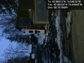
6 Dibert Rd. @40.9653,-74.6464
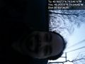
Silly grin, check. @40.9653,-74.6464
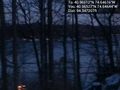
Best shot of the lake from here @40.9653,-74.6464


