Difference between revisions of "2014-01-04 50 8"
imported>GeorgDerReisende (new expedition to Frankfurt am Main-Riedberg) |
(retro-expedition report for Frankfurt am Main) |
||
| (3 intermediate revisions by 3 users not shown) | |||
| Line 5: | Line 5: | ||
}} | }} | ||
| − | + | ||
__NOTOC__ | __NOTOC__ | ||
== Location == | == Location == | ||
| Line 13: | Line 13: | ||
== Participants == | == Participants == | ||
| − | [[User:GeorgDerReisende|GeorgDerReisende]] | + | * [[User:GeorgDerReisende|GeorgDerReisende]] |
== Plans == | == Plans == | ||
| Line 20: | Line 20: | ||
== Expedition == | == Expedition == | ||
| − | |||
| − | + | At first I tried to hitchhike from the Dresdener Straße in Kassel, but for one and a half hours no cars stopped. Then I changed to the place behind the Auestadion and there a car stopped after five minutes. | |
| − | + | ||
| + | I arrived at the service station Taunusblick at 14:13. Then I walked from the service station to the hash. | ||
| + | I arrived there at 15:27, but 90 meters away. But from several places around the hash I couldn't reach it, the mud was too deep. | ||
== Photos == | == Photos == | ||
| − | |||
| − | |||
| − | |||
<gallery perrow="5"> | <gallery perrow="5"> | ||
| + | Image:2014-01-04 50 8 GeorgDerReisende 4826.jpg | behind this wall lies Riedberg | ||
| + | Image:2014-01-04 50 8 GeorgDerReisende 4874.jpg | 90 meters to the hash | ||
| + | Image:2014-01-04 50 8 GeorgDerReisende 4880.jpg | 28 meters to the hash | ||
| + | Image:2014-01-04 50 8 GeorgDerReisende 4884.jpg | the place from the other side | ||
| + | Image:2014-01-04 50 8 GeorgDerReisende 4882.jpg | my shoes after the try | ||
| + | Image:2014-01-04 50 8 GeorgDerReisende 4896.jpg | not near enough | ||
</gallery> | </gallery> | ||
| Line 36: | Line 40: | ||
<!-- Add any achievement ribbons you earned below, or remove this section --> | <!-- Add any achievement ribbons you earned below, or remove this section --> | ||
| + | * MNB? | ||
| + | |||
| + | == Retro-expedition == | ||
| + | |||
| + | On the 2022-12-20 I made a walk around some northern parts of Frankfurt and it was only a short detour for looking at the site of [[2014-01-04 50 8]] and I made it. I found the tree standing there but I hadn't the coordinates of that expedition. And I planned an other walk around that area and wanted to look for the exact hash. I took the same way and I came nearer and nearer and at the end I found me just at the information point with the explanation text. And I noted that the tree is no longer a natural monument. | ||
| + | |||
| + | == Photos == | ||
| − | < | + | <gallery> |
| − | + | File:2014-01-04 50 8 (2022-12-28) GeorgDerReisende 3506.jpg | arriving at the site | |
| − | + | File:2014-01-04 50 8 (2022-12-28) GeorgDerReisende 3507.jpg | nearer | |
| + | File:2014-01-04 50 8 (2022-12-28) GeorgDerReisende 3508.jpg | and nearer | ||
| + | File:2014-01-04 50 8 (2022-12-28) GeorgDerReisende 3509.jpg | nearer... | ||
| + | File:2014-01-04 50 8 (2022-12-28) GeorgDerReisende 3514.jpg | zero meters at the point | ||
| + | File:2014-01-04 50 8 (2022-12-28) GeorgDerReisende 3515.jpg | looking north | ||
| + | File:2014-01-04 50 8 (2022-12-28) GeorgDerReisende 3516.jpg | east | ||
| + | File:2014-01-04 50 8 (2022-12-28) GeorgDerReisende 3517.jpg | south | ||
| + | File:2014-01-04 50 8 (2022-12-28) GeorgDerReisende 3518.jpg | west | ||
| + | File:2014-01-04 50 8 (2022-12-28) GeorgDerReisende 3519.jpg | the geohasher | ||
| + | File:2014-01-04 50 8 (2022-12-28) GeorgDerReisende 3520.jpg | the tree near | ||
| + | File:2014-01-04 50 8 (2022-12-28) GeorgDerReisende 3521.jpg | the tree far | ||
| + | </gallery> | ||
| − | |||
| − | |||
| − | |||
| − | |||
| − | |||
[[Category:Expeditions]] | [[Category:Expeditions]] | ||
| − | |||
[[Category:Expeditions with photos]] | [[Category:Expeditions with photos]] | ||
| − | |||
| − | |||
| − | |||
| − | |||
| − | |||
| − | |||
| − | |||
| − | |||
[[Category:Coordinates not reached]] | [[Category:Coordinates not reached]] | ||
| − | |||
| − | |||
[[Category:Not reached - Mother Nature]] | [[Category:Not reached - Mother Nature]] | ||
| − | |||
| − | |||
| − | |||
| − | |||
| − | |||
| − | |||
| − | |||
| − | |||
| − | |||
| − | + | [[Category:Retro meetup]] | |
| + | [[Category:Retro coordinates reached]] | ||
| + | {{location|DE|HE|F}} | ||
Latest revision as of 14:40, 8 January 2023
| Sat 4 Jan 2014 in 50,8: 50.1753189, 8.6164718 geohashing.info google osm bing/os kml crox |
Location
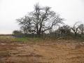
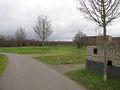
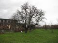
The hash lies at the southwestern edge of the new quarter Riedberg of Frankfurt am Main. Nearly all of the area seems to become rebuilt, but here are some small trees, where the planning says, they shall stay.
Participants
Plans
I will be there at 4 pm for a xkcd-meetup. I have to hitchhike to Frankfurt, which means I have to make a detour over the service station of Göttingen. Maybe I can do some exploration for openstreetmap.
Expedition
At first I tried to hitchhike from the Dresdener Straße in Kassel, but for one and a half hours no cars stopped. Then I changed to the place behind the Auestadion and there a car stopped after five minutes.
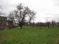
I arrived at the service station Taunusblick at 14:13. Then I walked from the service station to the hash. I arrived there at 15:27, but 90 meters away. But from several places around the hash I couldn't reach it, the mud was too deep.
Photos
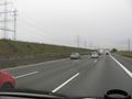
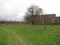
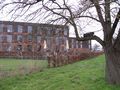
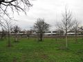
behind this wall lies Riedberg
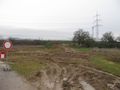
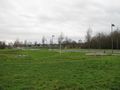
90 meters to the hash
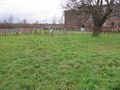
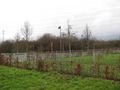
28 meters to the hash
the place from the other side
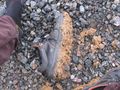
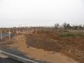
my shoes after the try
not near enough


Achievements
- MNB?
Retro-expedition
On the 2022-12-20 I made a walk around some northern parts of Frankfurt and it was only a short detour for looking at the site of 2014-01-04 50 8 and I made it. I found the tree standing there but I hadn't the coordinates of that expedition. And I planned an other walk around that area and wanted to look for the exact hash. I took the same way and I came nearer and nearer and at the end I found me just at the information point with the explanation text. And I noted that the tree is no longer a natural monument.
Photos
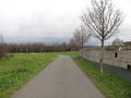
arriving at the site
nearer
and nearer
nearer...
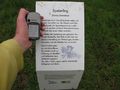
zero meters at the point
looking north
east
south
west
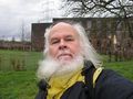
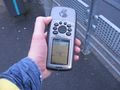
the geohasher
the tree near
the tree far
_GeorgDerReisende_3506.jpg)
_GeorgDerReisende_3507.jpg)
_GeorgDerReisende_3508.jpg)
_GeorgDerReisende_3509.jpg)
_GeorgDerReisende_3514.jpg)
_GeorgDerReisende_3515.jpg)
_GeorgDerReisende_3516.jpg)
_GeorgDerReisende_3517.jpg)
_GeorgDerReisende_3518.jpg)
_GeorgDerReisende_3519.jpg)
_GeorgDerReisende_3520.jpg)
_GeorgDerReisende_3521.jpg)