Difference between revisions of "2014-01-05 43 -116"
From Geohashing
imported>Eldin (An expedition message sent via Geohash Droid for Android.) |
imported>FippeBot m (Location) |
||
| (2 intermediate revisions by one other user not shown) | |||
| Line 1: | Line 1: | ||
| − | |||
| − | |||
| − | |||
| − | |||
| − | |||
| − | |||
| − | |||
| − | |||
| − | |||
| − | |||
{{meetup graticule | {{meetup graticule | ||
| lat=43 | | lat=43 | ||
| Line 15: | Line 5: | ||
}} | }} | ||
| − | |||
__NOTOC__ | __NOTOC__ | ||
== Location == | == Location == | ||
| − | + | South of Kuna, just off Nicholson Rd | |
== Participants == | == Participants == | ||
| − | + | * [[User:Eldin|Eldin]] | |
| − | |||
| − | |||
| − | |||
| − | |||
== Expedition == | == Expedition == | ||
| − | + | It was an easy drive very nearly to the hashpoint, and an easy walk from the road to the spot. So an easy success to mark 1 year since my very first geohashing expedition. | |
| − | == | + | *1 year hashiversary, hashed. -- [[User:Eldin|Eldin]] ([[User talk:Eldin|talk]]) [http://www.openstreetmap.org/?lat=43.40068655&lon=-116.48807187&zoom=16&layers=B000FTF @43.4007,-116.4881] 17:07, 5 January 2014 (MST) |
| − | |||
== Photos == | == Photos == | ||
| − | |||
| − | |||
| − | |||
<gallery perrow="5"> | <gallery perrow="5"> | ||
| + | File:2014-01-05 43 -116 proof.jpg | Proof that the coordinates were reached. | ||
| + | File:2014-01-05 43 -116 grin.jpg | Grinning geohasher. | ||
| + | File:2014-01-05 43 -116 view1.jpg | Looking north from the hashpoint, towards my car. | ||
| + | File:2014-01-05 43 -116 view2.jpg | And looking to the southeast. | ||
| + | File:2014-01-05 43 -116 point.jpg | The hashpoint, crudely marked. | ||
</gallery> | </gallery> | ||
== Achievements == | == Achievements == | ||
{{#vardefine:ribbonwidth|800px}} | {{#vardefine:ribbonwidth|800px}} | ||
| − | + | {{Land geohash | latitude = 43 | longitude = -116 | date = 2014-01-05 | name = [[User:Eldin|Eldin]]}} | |
| − | + | {{Hashiversary | new = 2014-01-05_43_-116 | original = 2013-01-05_43_-116 | ordinal = 1st | name = [[User:Eldin|Eldin]] | gender = his}} | |
| − | |||
| − | |||
| − | |||
| − | [[ | ||
| − | |||
| − | |||
| − | |||
| − | |||
| − | |||
| − | |||
[[Category:Expeditions]] | [[Category:Expeditions]] | ||
| − | |||
[[Category:Expeditions with photos]] | [[Category:Expeditions with photos]] | ||
| − | |||
| − | |||
| − | |||
| − | |||
| − | |||
[[Category:Coordinates reached]] | [[Category:Coordinates reached]] | ||
| − | + | {{location|US|ID|AA}} | |
| − | |||
| − | |||
| − | |||
| − | |||
| − | |||
| − | |||
| − | |||
| − | |||
| − | |||
| − | |||
| − | |||
| − | |||
| − | |||
| − | |||
| − | |||
| − | |||
| − | |||
Latest revision as of 05:07, 14 August 2019
| Sun 5 Jan 2014 in 43,-116: 43.4007173, -116.4881152 geohashing.info google osm bing/os kml crox |
Location
South of Kuna, just off Nicholson Rd
Participants
Expedition
It was an easy drive very nearly to the hashpoint, and an easy walk from the road to the spot. So an easy success to mark 1 year since my very first geohashing expedition.
- 1 year hashiversary, hashed. -- Eldin (talk) @43.4007,-116.4881 17:07, 5 January 2014 (MST)
Photos
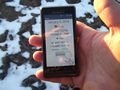
Proof that the coordinates were reached.
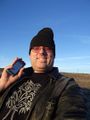
Grinning geohasher.
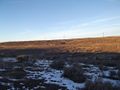
Looking north from the hashpoint, towards my car.
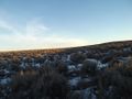
And looking to the southeast.
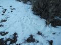
The hashpoint, crudely marked.


Achievements
Eldin earned the Land geohash achievement
|
Eldin earned the 1st Hashiversary achievement
|