Difference between revisions of "2014-01-06 51 9"
From Geohashing
imported>GeorgDerReisende (new expedition to Niestetal-Sondershausen) |
imported>FippeBot m (Location) |
||
| (2 intermediate revisions by one other user not shown) | |||
| Line 1: | Line 1: | ||
| − | |||
| − | |||
| − | |||
| − | |||
| − | |||
| − | |||
| − | |||
| − | |||
| − | |||
| − | |||
{{meetup graticule | {{meetup graticule | ||
| lat=51 | | lat=51 | ||
| Line 18: | Line 8: | ||
__NOTOC__ | __NOTOC__ | ||
== Location == | == Location == | ||
| − | + | ||
| + | The hash lies in a backyard of a house in the Haunküppelstraße in Niestetal-Sandershausen. | ||
== Participants == | == Participants == | ||
| − | + | ||
| − | + | [[User:GeorgDerReisende|GeorgDerReisende]] | |
== Plans == | == Plans == | ||
| − | + | ||
| + | I wanted to go there by bus and wanted to have a look to that place. | ||
== Expedition == | == Expedition == | ||
| − | + | ||
| + | I went to Sandershausen by bus and went to the Haunküppelstraße. I found the house and at first I thought, that the hash lay in the yard of the house in the back, more than five meters away. After finding this out, I tried a dance, and with this I reached the hash by five meters. | ||
== Tracklog == | == Tracklog == | ||
| Line 38: | Line 31: | ||
--> | --> | ||
<gallery perrow="5"> | <gallery perrow="5"> | ||
| + | Image:2014-01-06 51 9 GeorgDerReisende 4998.jpg | Hannoversche Straße, the main street of Sandershausen to the south | ||
| + | Image:2014-01-06 51 9 GeorgDerReisende 4999.jpg | Hannoversche Straße, the main street of Sandershausen to the notth | ||
| + | Image:2014-01-06 51 9 GeorgDerReisende 5000.jpg | the Haunküppelstraße | ||
| + | Image:2014-01-06 51 9 GeorgDerReisende 5006.jpg | nr. 18 | ||
| + | Image:2014-01-06 51 9 GeorgDerReisende 5007.jpg | nr. 18 to the left, nr. 16 to the right, nr. 18a in the back | ||
| + | Image:2014-01-06 51 9 GeorgDerReisende 5010.jpg | after the first try | ||
| + | Image:2014-01-06 51 9 GeorgDerReisende 5013.jpg | proof of 5 m | ||
| + | Image:2014-01-06 51 9 GeorgDerReisende 5017.jpg | proof2 | ||
</gallery> | </gallery> | ||
| Line 44: | Line 45: | ||
<!-- Add any achievement ribbons you earned below, or remove this section --> | <!-- Add any achievement ribbons you earned below, or remove this section --> | ||
| + | {{Public transport geohash | latitude = 51 | longitude = 9 | date = 2014-01-06 | busline = buses 32 & 31 | name = GeorgDerReisende }} | ||
| − | + | [[Category:Expeditions]] | |
| − | |||
| − | [[Category: | ||
| − | + | [[Category:Expeditions with photos]] | |
| − | |||
| − | [[Category: | ||
| − | |||
| − | |||
| − | |||
| − | |||
| − | |||
| − | |||
| − | |||
| − | |||
| − | |||
| − | |||
[[Category:Coordinates reached]] | [[Category:Coordinates reached]] | ||
| − | + | {{location|DE|HE|KS}} | |
| − | |||
| − | |||
| − | |||
| − | |||
| − | |||
| − | |||
| − | |||
| − | |||
| − | |||
| − | |||
| − | |||
| − | |||
| − | |||
| − | |||
| − | |||
| − | |||
| − | |||
Latest revision as of 05:09, 14 August 2019
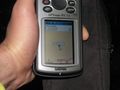
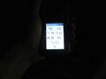
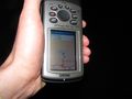
| Mon 6 Jan 2014 in 51,9: 51.3203990, 9.5435710 geohashing.info google osm bing/os kml crox |
Location
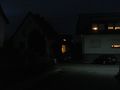
The hash lies in a backyard of a house in the Haunküppelstraße in Niestetal-Sandershausen.
Participants
Plans
I wanted to go there by bus and wanted to have a look to that place.
Expedition
I went to Sandershausen by bus and went to the Haunküppelstraße. I found the house and at first I thought, that the hash lay in the yard of the house in the back, more than five meters away. After finding this out, I tried a dance, and with this I reached the hash by five meters.
Tracklog
Photos
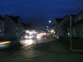
Hannoversche Straße, the main street of Sandershausen to the south
Hannoversche Straße, the main street of Sandershausen to the notth
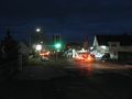
the Haunküppelstraße
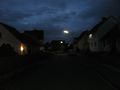
nr. 18
nr. 18 to the left, nr. 16 to the right, nr. 18a in the back
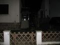
after the first try
proof of 5 m
proof2


Achievements
GeorgDerReisende earned the Public transport geohash achievement
|