Difference between revisions of "2014-01-08 47 8"
imported>Guga2112 ([retro picture] The wonderful view from Hönggerberg) |
imported>Guga2112 (→Expedition) |
||
| Line 33: | Line 33: | ||
<!-- how it all turned out. your narrative goes here. --> | <!-- how it all turned out. your narrative goes here. --> | ||
''coming soon'' | ''coming soon'' | ||
| + | |||
| + | [[User:Guga2112|Guga2112]]<br> | ||
| + | I came back home from work at around 5pm. I already intended to jog 6km today, and when I saw the Geohash was exactly 2.9km from my home I thought to myself, hey, why not. The only problem is that these 2.9km were EXTREMELY STEEP. However, I thought a little bit of jogging uphill would be a nice training, so I put on my gear and left. | ||
| + | After 18 minutes where I was pondering how overrated breathing is, I approached the hashpoint and slowed down. It was extremely dark and I couldn't see the paths that brought to the hash. Then I noticed it: the dreaded fence. Nobody was there to help me, it was too late and even if there were anybody I hardly think I would have been able to explain what I was trying to do in German. So I went to the nearest publicly accessible point (48m away, according to my GPS) and took a nice picture of Zurich by night seen by the Hönggerberg mountain. Taking night pictures with a mobile phone isn't anyway that easy. | ||
| + | Coming back home, instead, was a piece of cake. 3kms of downhill jog, my knees and ankles still hurt, but hey, at least I was able to break my personal pace record :D | ||
== Tracklog == | == Tracklog == | ||
Revision as of 07:55, 9 January 2014
| Wed 8 Jan 2014 in 47,8: 47.3997770, 8.5120076 geohashing.info google osm bing/os kml crox |
Location
An allotment garden in Zurich's Höngg district.
Participants
Plans
- S9 train to Hardbrücke, leaving Zurich 41/42 at 12.04am
- 72 bus to Bucheggplatz
- 69 bus to Weidbadstrasse
- Arrive at 12.21 and see if the allotments are freely accessible
I'll be just jogging there after the sunset, no special plans, no exact times. I'm sorry I just saw your plans, but anyway I couldn't be there since I'm currently at work --Guga2112 (talk) 07:15, 8 January 2014 (EST)
Expedition
coming soon
Guga2112
I came back home from work at around 5pm. I already intended to jog 6km today, and when I saw the Geohash was exactly 2.9km from my home I thought to myself, hey, why not. The only problem is that these 2.9km were EXTREMELY STEEP. However, I thought a little bit of jogging uphill would be a nice training, so I put on my gear and left.
After 18 minutes where I was pondering how overrated breathing is, I approached the hashpoint and slowed down. It was extremely dark and I couldn't see the paths that brought to the hash. Then I noticed it: the dreaded fence. Nobody was there to help me, it was too late and even if there were anybody I hardly think I would have been able to explain what I was trying to do in German. So I went to the nearest publicly accessible point (48m away, according to my GPS) and took a nice picture of Zurich by night seen by the Hönggerberg mountain. Taking night pictures with a mobile phone isn't anyway that easy.
Coming back home, instead, was a piece of cake. 3kms of downhill jog, my knees and ankles still hurt, but hey, at least I was able to break my personal pace record :D
Tracklog
Calamus: On EveryTrail
Photos
coming soon-ish
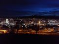
The wonderful view from Hönggerberg

Achievements
Calamus and Chris earned the Ambassador achievement
|
Guga2112 earned the No trespassing consolation prize
|