Difference between revisions of "2014-01-11 49 11"
From Geohashing
imported>Frob |
m |
||
| (4 intermediate revisions by 2 users not shown) | |||
| Line 19: | Line 19: | ||
== Location == | == Location == | ||
<!-- where you've surveyed the hash to be --> | <!-- where you've surveyed the hash to be --> | ||
| + | Open Field in Weidmannsgesees (near bus stop at crossing Rackersdorf); county Bayreuth, Fränkische Schweiz | ||
| + | |||
Acker bei Weidmannsgesees (Nähe Bushaltestelle/Kreuzung Rackersdorf); Landkreis Bayreuth, Fränkische Schweiz | Acker bei Weidmannsgesees (Nähe Bushaltestelle/Kreuzung Rackersdorf); Landkreis Bayreuth, Fränkische Schweiz | ||
== Participants == | == Participants == | ||
| Line 26: | Line 28: | ||
== Plans == | == Plans == | ||
<!-- what were the original plans --> | <!-- what were the original plans --> | ||
| − | + | ||
| + | visiting a geocache nearby and then just to have a look | ||
| + | |||
== Expedition == | == Expedition == | ||
<!-- how it all turned out. your narrative goes here. --> | <!-- how it all turned out. your narrative goes here. --> | ||
| − | + | reached the bus stop on time and walked to the coords w/o effort. Earned a few looks from passers-by (two cars, a local motorcycle driver) and left at 4:15pm. | |
| + | |||
== Tracklog == | == Tracklog == | ||
<!-- if your GPS device keeps a log, you may post a link here --> | <!-- if your GPS device keeps a log, you may post a link here --> | ||
| Line 38: | Line 43: | ||
--> | --> | ||
<gallery perrow="5"> | <gallery perrow="5"> | ||
| + | Image:frob140111.jpg | On location (proof in EXIF) | ||
</gallery> | </gallery> | ||
| Line 44: | Line 50: | ||
<!-- Add any achievement ribbons you earned below, or remove this section --> | <!-- Add any achievement ribbons you earned below, or remove this section --> | ||
| − | |||
| − | |||
| − | |||
| − | |||
| − | |||
| − | |||
| − | |||
| − | |||
| − | |||
| − | |||
| − | |||
[[Category:Expeditions]] | [[Category:Expeditions]] | ||
| − | |||
[[Category:Expeditions with photos]] | [[Category:Expeditions with photos]] | ||
| − | |||
| − | |||
| − | |||
| − | |||
| − | |||
[[Category:Coordinates reached]] | [[Category:Coordinates reached]] | ||
| − | + | {{location|DE|BY|BT}} | |
| − | |||
| − | |||
| − | |||
| − | |||
| − | |||
| − | |||
| − | |||
| − | |||
| − | |||
| − | |||
| − | |||
| − | |||
| − | |||
| − | |||
| − | |||
| − | |||
| − | |||
Latest revision as of 13:54, 22 September 2021
| Sat 11 Jan 2014 in 49,11: 49.7893381, 11.3854572 geohashing.info google osm bing/os kml crox |
Location
Open Field in Weidmannsgesees (near bus stop at crossing Rackersdorf); county Bayreuth, Fränkische Schweiz
Acker bei Weidmannsgesees (Nähe Bushaltestelle/Kreuzung Rackersdorf); Landkreis Bayreuth, Fränkische Schweiz
Participants
Plans
visiting a geocache nearby and then just to have a look
Expedition
reached the bus stop on time and walked to the coords w/o effort. Earned a few looks from passers-by (two cars, a local motorcycle driver) and left at 4:15pm.
Tracklog
Photos
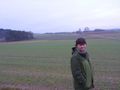
On location (proof in EXIF)
