Difference between revisions of "2014-01-12 38 -121"
imported>Chandru (Created page with "Test") |
imported>FippeBot m (Location) |
||
| (8 intermediate revisions by 2 users not shown) | |||
| Line 1: | Line 1: | ||
| − | + | ||
| + | <!-- If you did not specify these parameters in the template, please substitute appropriate values for IMAGE, LAT, LON, and DATE (YYYY-MM-DD format) | ||
| + | |||
| + | [[Image:{{{image|IMAGE}}}|thumb|left]] | ||
| + | |||
| + | Remove this section if you don't want an image at the top (left) of your report. You should remove the "Image:" or "File:" | ||
| + | tag from your image file name, and replace the all upper-case word IMAGE in the above line. | ||
| + | |||
| + | And DON'T FORGET to add your expedition and the best photo you took to the gallery on the Main Page! We'd love to read your report, but that means we first have to discover it! :) | ||
| + | --> | ||
| + | {{meetup graticule | ||
| + | | lat=38 | ||
| + | | lon=-121 | ||
| + | | date=2014-01-12 | ||
| + | }} | ||
| + | |||
| + | <!-- edit as necessary --> | ||
| + | __NOTOC__ | ||
| + | == Location == | ||
| + | <!-- where you've surveyed the hash to be --> | ||
| + | Between the PKA Fraternity House and Elmwood Street, Davis, CA, USA. | ||
| + | == Participants == | ||
| + | <!-- who attended: If you link to your wiki user name in this section, your expedition will be picked up by the various statistics generated for geohashing. You may use three tildes ~ as a shortcut to automatically insert the user signature of the account you are editing with. | ||
| + | --> | ||
| + | [[User:Chandru|Chandru]] | ||
| + | |||
| + | == Expedition == | ||
| + | <!-- how it all turned out. your narrative goes here. --> | ||
| + | It's been WAY too long since I've last attempted a hash. The last time I wrote up a report was almost a year ago. On a whim I checked the coordinate calculator Saturday night, and saw that the hashpoint was extremely close to everything. It was just one mile from my house, so I could easily get there. I had planned to bike, but it was too windy. Thankfully, since this place was so convienently located, I was able to take the bus there! The bus stop was close to the hashpoint (~0.1 miles). After I exited the bus, I walked down Russell Boulevard towards the hashpoint. | ||
| + | |||
| + | Now is the time where I should mention that I just got an iPhone (yeah, I know). As a result, I can no longer use Geohash Droid. I found a geohash app, but it isn't as accurate as the amazing Android application. It doesn't tell me how close I am, beyond tenths of a mile. As I recall, successful geohashes require me to be within 50 feet of the hashpoint. So, I had to guess. | ||
| + | |||
| + | I could tell on Google Maps that the hashpoint was behind the Pi Kappa Alpha frat house. Being someone who was spending a Sunday afternoon geohashing, I felt I didn't belong in such a place. At this point, I noticed a sign that read "Elm Street." Instead of being an actual road, it appeared to simply be a gravel driveway. Upon closer look, there was a small paved path that was only big enough for pedestrians and bikes. I entered the path, and exited on a different street, called Elmwood Drive. Why Davis city planners decided to connect Elm and Elmwood remains a mystery to me. Elmwood Drive is a quiet street, as opposed to the arterial Rusell Blvd. I went to a small cul-de-sac close to the hashpoint, and took my picture there. | ||
| + | == Photos == | ||
| + | <!-- Insert pictures between the gallery tags using the following format: | ||
| + | Image:2012-##-## ## ## Alpha.jpg | Witty Comment | ||
| + | --> | ||
| + | <gallery perrow="4"> | ||
| + | Image:2014_01_12_bus.jpg|On the bus! | ||
| + | Image:2014_01_12_selfie.jpg|At the hashpoint! | ||
| + | Image:2014_01_12_map.jpg|The closest I got to the hashpoint. | ||
| + | </gallery> | ||
| + | |||
| + | The photo editor was being weird, so I instagrammed the other photos! | ||
| + | http://instagram.com/p/jGZnDdR-oe/# (Frat house) | ||
| + | http://instagram.com/p/jGZKykR-oP/# (That cool path) | ||
| + | == Achievements == | ||
| + | {{#vardefine:ribbonwidth|800px}} | ||
| + | <!-- Add any achievement ribbons you earned below, or remove this section --> | ||
| + | {{Public transport geohash | ||
| + | | latitude = 38 | ||
| + | | longitude = -121 | ||
| + | | date = 2014-01-12 | ||
| + | | busline = Unitrans | ||
| + | | name = Chandru | ||
| + | | image = 2014_01_12_bus.jpg | ||
| + | }} | ||
| + | |||
| + | <!-- =============== USEFUL CATEGORIES FOLLOW ================ | ||
| + | Delete the next line ONLY if you have chosen the appropriate categories below. If you are unsure, don't worry. People will read your report and help you with the classification. --> | ||
| + | |||
| + | <!-- Potential categories. Please include all the ones appropriate to your expedition --> | ||
| + | <!-- If this is a planning page: | ||
| + | [[Category:Expedition planning]] | ||
| + | --> | ||
| + | |||
| + | <!-- An actual expedition: | ||
| + | [[Category:Expeditions]] | ||
| + | -- and one or more of -- | ||
| + | [[Category:Expeditions with photos]] | ||
| + | [[Category:Expeditions with videos]] | ||
| + | [[Category:Expedition without GPS]] | ||
| + | --> | ||
| + | |||
| + | <!-- if you reached your coords: | ||
| + | [[Category:Coordinates reached]] | ||
| + | |||
| + | |||
| + | --><!-- or if you failed :( | ||
| + | [[Category:Coordinates not reached]] | ||
| + | -- and a reason -- | ||
| + | When there is a natural obstacle between you and the target: | ||
| + | [[Category:Not reached - Mother Nature]] | ||
| + | |||
| + | When there is a man-made obstacle between you and the target: | ||
| + | [[Category:Not reached - No public access]] | ||
| + | |||
| + | When you failed get your GPS, car, bike or such to work: | ||
| + | [[Category:Not reached - Technology]] | ||
| + | |||
| + | When you went to an alternate location instead of the actual geohash: | ||
| + | [[Category:Not reached - Did not attempt]] | ||
| + | |||
| + | (Don't forget to delete this final close comment marker) --> | ||
| + | |||
| + | |||
| + | [[Category:Coordinates reached]] | ||
| + | [[Category:Expeditions]] | ||
| + | [[Category:Expeditions with photos]] | ||
| + | {{location|US|CA|YO}} | ||
Latest revision as of 05:12, 14 August 2019
| Sun 12 Jan 2014 in 38,-121: 38.5469398, -121.7559078 geohashing.info google osm bing/os kml crox |
Location
Between the PKA Fraternity House and Elmwood Street, Davis, CA, USA.
Participants
Expedition
It's been WAY too long since I've last attempted a hash. The last time I wrote up a report was almost a year ago. On a whim I checked the coordinate calculator Saturday night, and saw that the hashpoint was extremely close to everything. It was just one mile from my house, so I could easily get there. I had planned to bike, but it was too windy. Thankfully, since this place was so convienently located, I was able to take the bus there! The bus stop was close to the hashpoint (~0.1 miles). After I exited the bus, I walked down Russell Boulevard towards the hashpoint.
Now is the time where I should mention that I just got an iPhone (yeah, I know). As a result, I can no longer use Geohash Droid. I found a geohash app, but it isn't as accurate as the amazing Android application. It doesn't tell me how close I am, beyond tenths of a mile. As I recall, successful geohashes require me to be within 50 feet of the hashpoint. So, I had to guess.
I could tell on Google Maps that the hashpoint was behind the Pi Kappa Alpha frat house. Being someone who was spending a Sunday afternoon geohashing, I felt I didn't belong in such a place. At this point, I noticed a sign that read "Elm Street." Instead of being an actual road, it appeared to simply be a gravel driveway. Upon closer look, there was a small paved path that was only big enough for pedestrians and bikes. I entered the path, and exited on a different street, called Elmwood Drive. Why Davis city planners decided to connect Elm and Elmwood remains a mystery to me. Elmwood Drive is a quiet street, as opposed to the arterial Rusell Blvd. I went to a small cul-de-sac close to the hashpoint, and took my picture there.
Photos
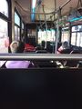
On the bus!

At the hashpoint!
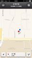
The closest I got to the hashpoint.


The photo editor was being weird, so I instagrammed the other photos! http://instagram.com/p/jGZnDdR-oe/# (Frat house) http://instagram.com/p/jGZKykR-oP/# (That cool path)
Achievements
Chandru earned the Public transport geohash achievement
|