Difference between revisions of "2014-01-12 44 -123"
imported>Frogman (→Plans) |
imported>FippeBot m (Location) |
||
| (5 intermediate revisions by one other user not shown) | |||
| Line 22: | Line 22: | ||
== Participants == | == Participants == | ||
* [[User:Frogman|Frogman]] | * [[User:Frogman|Frogman]] | ||
| + | * [[User:AlecS|AlecS]] | ||
| + | * Greg | ||
| + | * Alison | ||
| + | * Callie | ||
== Plans == | == Plans == | ||
| Line 27: | Line 31: | ||
== Expedition == | == Expedition == | ||
| − | + | We drove out US Numbered Highway 20 towards Newport, but turned off on some side roads to get into the National Forest. Getting to the hashpoint itself was pretty easy, but wet; we hiked up the side of a hill and by the time we were done we were pretty wet and muddy. The area around the hashpoint was moderately forested and there were a lot of ferns. | |
| + | |||
| + | Afterwards we went to Mo's, even though Newport was way out of our way. We sang songs and joked and it was a good time for all! | ||
== Tracklog == | == Tracklog == | ||
| Line 37: | Line 43: | ||
--> | --> | ||
<gallery perrow="5"> | <gallery perrow="5"> | ||
| + | Image:2014-01-12 44 -123 proof.jpg | Proof! | ||
| + | Image:2014-01-12 44 -123 celebrations.jpg | Everyone was super excited to be there. | ||
| + | Image:2014-01-12 44 -123 meta.jpg | Gotta take a lot of pictures! | ||
| + | Image:2014-01-12 44 -123 grins.jpg | Goofy motion-blurred grins. | ||
| + | Image:2014-01-12 44 -123 descent.jpg | Time to head back down the hill. | ||
| + | Image:2014-01-12 44 -123 machete.jpg | [[User:AlecS|AlecS]] brought his new machete in case we needed to cut some plant-life. We didn't, but he defaced a tree anyway. | ||
</gallery> | </gallery> | ||
== Achievements == | == Achievements == | ||
| − | |||
| − | |||
| − | |||
| − | |||
| − | |||
| − | |||
| − | |||
| − | |||
| − | |||
| − | |||
[[Category:Expeditions]] | [[Category:Expeditions]] | ||
| − | |||
[[Category:Expeditions with photos]] | [[Category:Expeditions with photos]] | ||
| − | |||
| − | |||
| − | |||
| − | |||
| − | |||
[[Category:Coordinates reached]] | [[Category:Coordinates reached]] | ||
| − | + | {{location|US|OR|LC}} | |
| − | |||
| − | |||
| − | |||
| − | |||
| − | |||
| − | |||
| − | |||
| − | |||
| − | |||
| − | |||
| − | |||
| − | |||
| − | |||
| − | |||
| − | |||
| − | |||
| − | |||
Latest revision as of 06:55, 6 August 2019
| Sun 12 Jan 2014 in 44,-123: 44.5469398, -123.7559078 geohashing.info google osm bing/os kml crox |
Location
On a hill in Siuslaw National Forest.
Participants
Plans
After some deliberations on the state of the weather, we decided to attempt this geohash.
Expedition
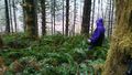
We drove out US Numbered Highway 20 towards Newport, but turned off on some side roads to get into the National Forest. Getting to the hashpoint itself was pretty easy, but wet; we hiked up the side of a hill and by the time we were done we were pretty wet and muddy. The area around the hashpoint was moderately forested and there were a lot of ferns.
Afterwards we went to Mo's, even though Newport was way out of our way. We sang songs and joked and it was a good time for all!
Tracklog
Photos
Proof!
Everyone was super excited to be there.
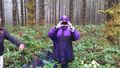
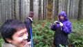
Gotta take a lot of pictures!
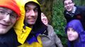
Goofy motion-blurred grins.
Time to head back down the hill.
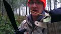
AlecS brought his new machete in case we needed to cut some plant-life. We didn't, but he defaced a tree anyway.


